Knowledge Base
Search Results
3D Laser Scanning Explained
3D laser scanning is a construction, engineering, and architectural tool often used to document the existing conditions (as-builts) of any structure.
3D laser scanners use LiDAR (light detection and ranging) to measure and record precise locations and distances, ultimately producing a point cloud file. These lightweight and mobile scanners produce highly accurate digital measurements and images quickly and easily for use in construction and engineering projects. That data is invaluable in design, prefabrication, asset management, and facility modifications.
Precision as-built laser scans have huge benefits for construction companies, and industrial LiDAR scanners are portable, can be automated, and are accurate within millimeters.
How Does 3D Laser Scanning Work?
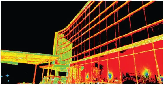
The primary way a laser scanner works is to send light pulses at high speed which reflect off objects and return to the scanner’s sensor (LiDAR). For each pulse, the distance between the scanner and object is measured by determining the elapsed time between the sent and received pulses. Each data point is converted to a pixel with a known x, y, and z coordinate.
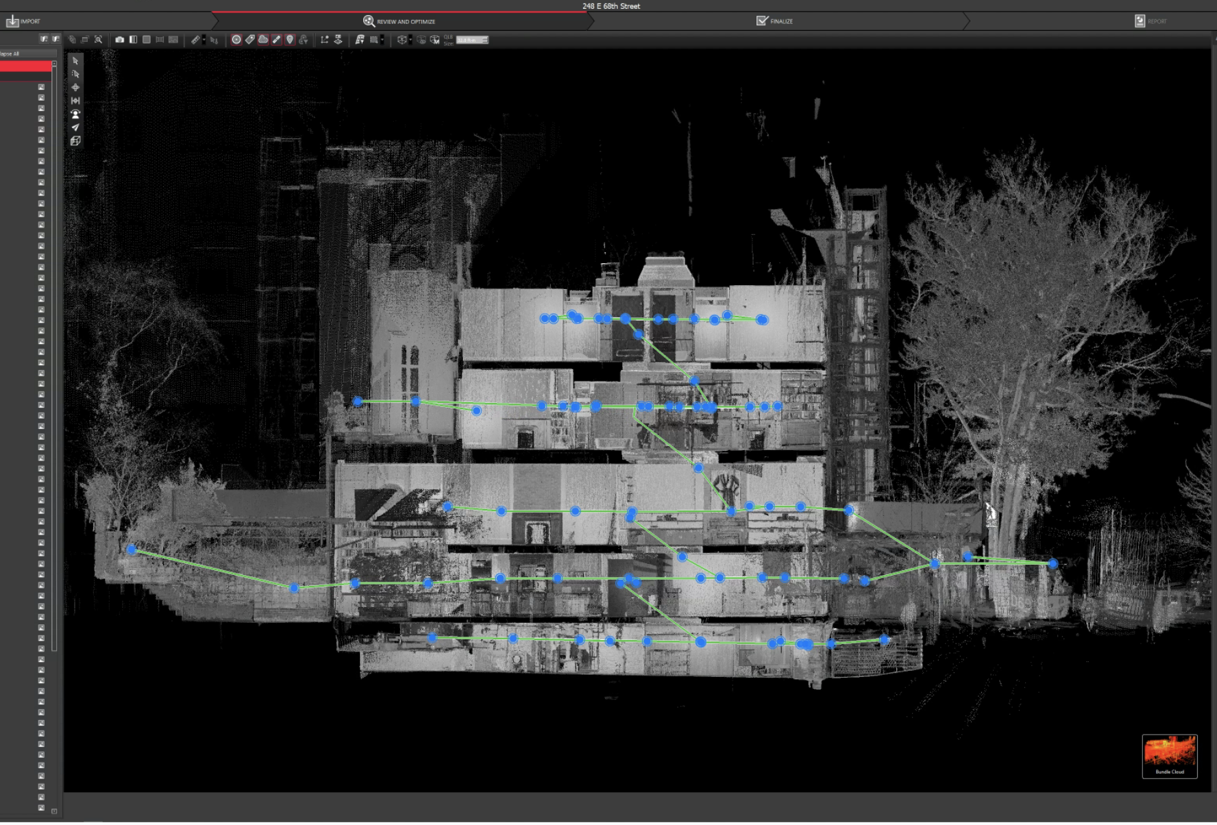
Laser scans are taken in multiple positions around a site from varying viewpoints. Millions of data points are captured and processed into a point cloud, creating an accurate 3D as built data set of the site. This all happens very quickly, with some scanners, like our Leica RTC360, capturing and calculating 2 million points per second with 2-4 mm accuracy.
The simplest way to break down how laser scanning works is to talk about what happens when a Project Manager takes a scanner into the field to walk you through the process.
Can 3D Laser Scanners Capture Data Quickly?
Before anyone walks onto the site to be scanned, it is vital to have a clear idea of what the data will be used for. Because while 3D laser scanning is the most efficient way to generate data points for mapping and modeling, it still requires a highly skilled and trained technician and hours or a few days on site to capture the needed data before our engineers can then create custom deliverables like 3D virtual tours, 3D flythroughs, Revit BIM models, CAD BIM models, Mesh models, 2D CAD drawings, and as-built drawings to suit your needs.
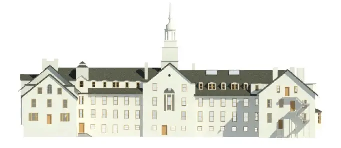
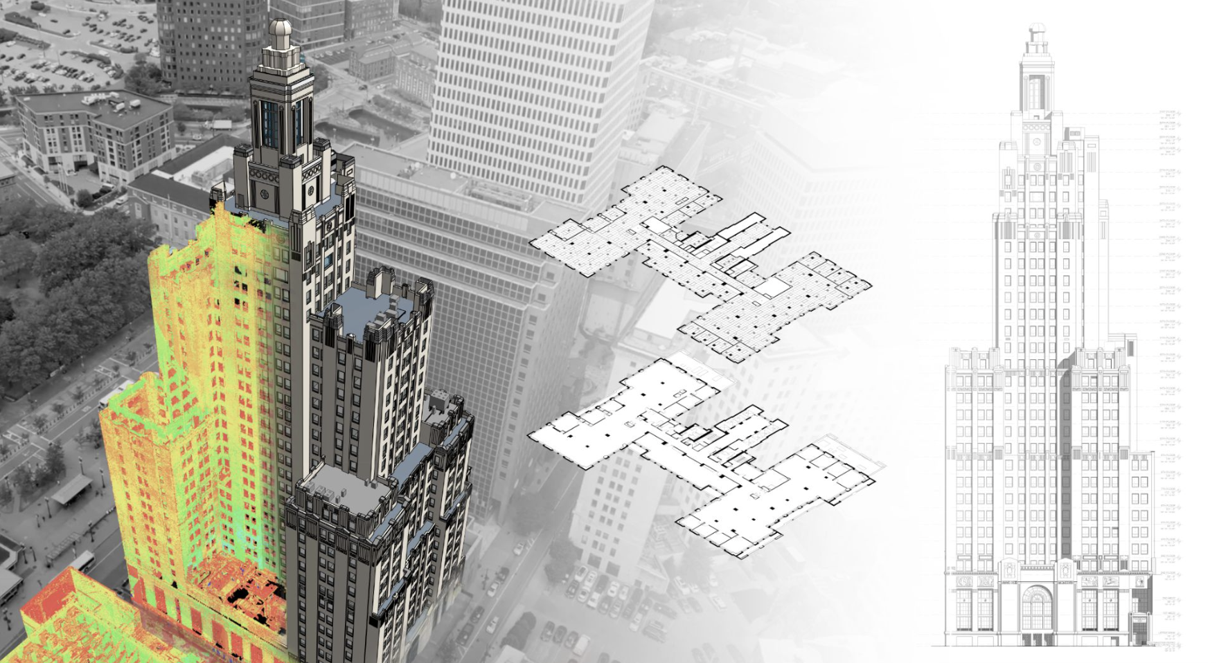
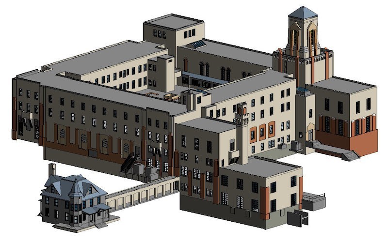
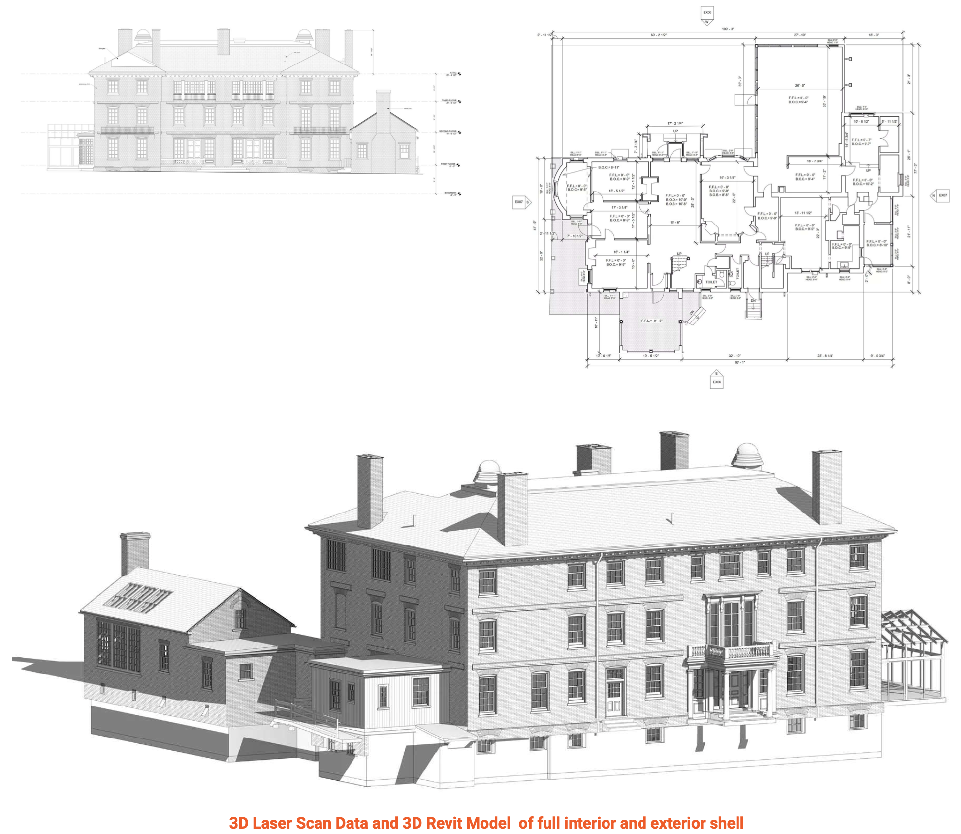
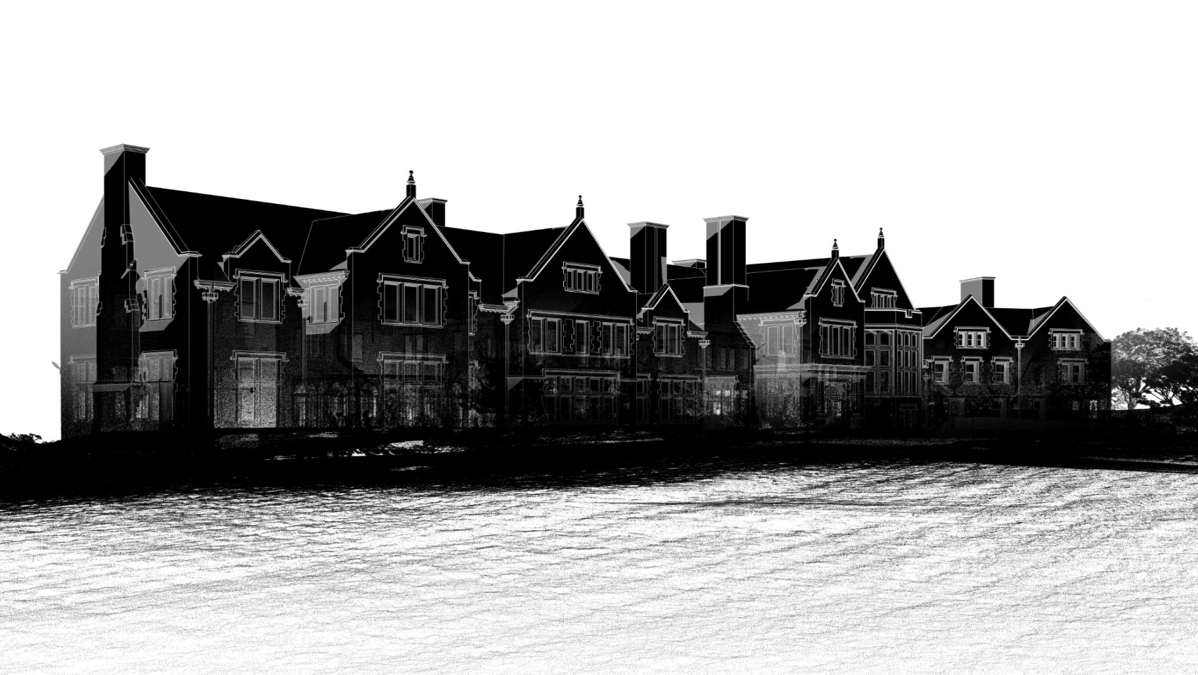
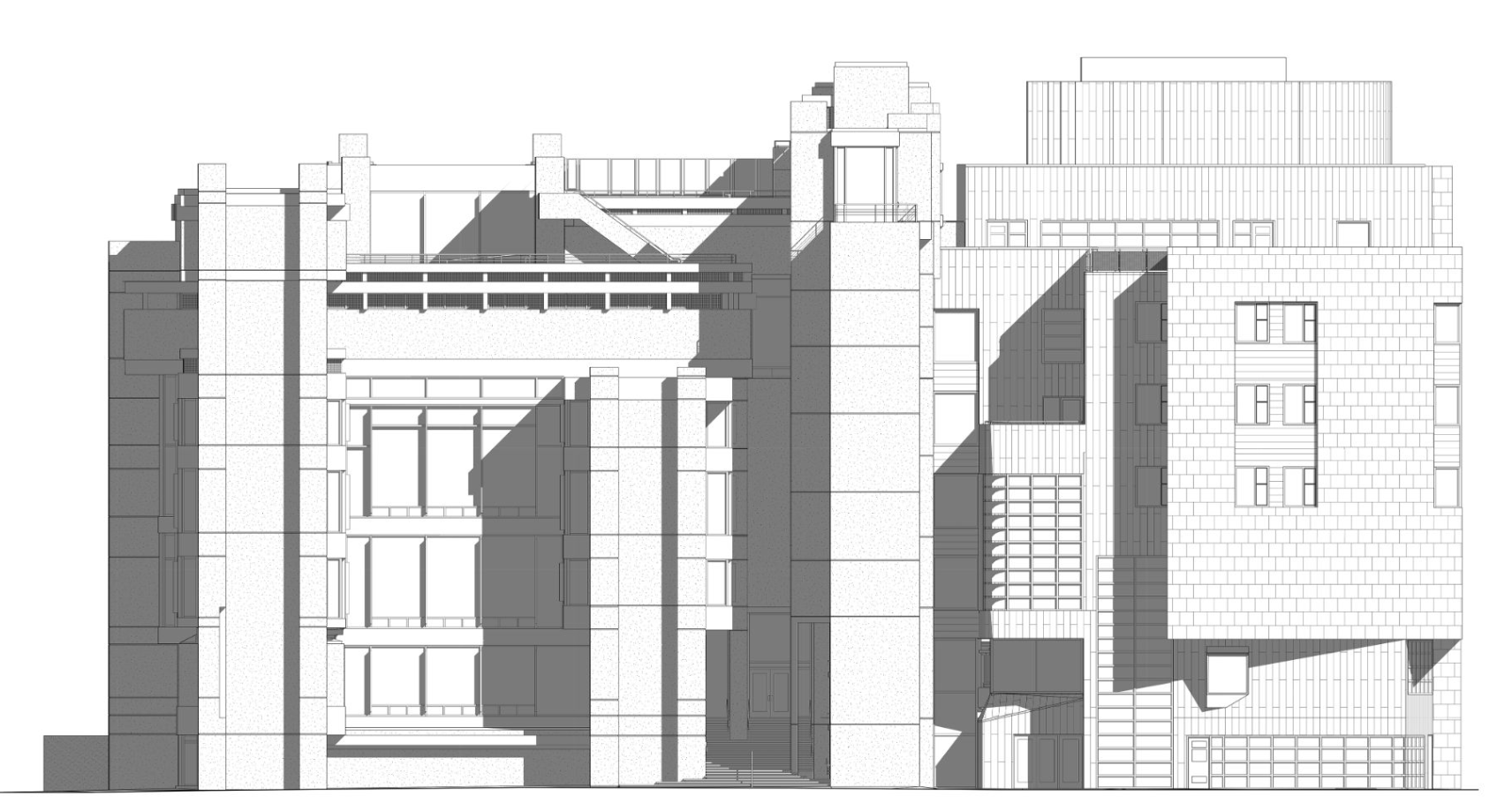
For instance, when Existing Conditions is called on to bring our 3D laser scanning services to a historical building for an accurate as built survey, we need a very high-resolution scan to produce a 3D model documenting precise building details for a complete update and restoration project, as we did for the 100-year-old residence hall you see here.
But for a recent survey of a hospital in Marysville, Ohio, the client required a simple 2D CAD drawing of the façade so that their roofing contractor had accurate measurements to fabricate needed soffits and fascia before coming on site. This saved the client and the contractor a lot of time and money by eliminating the need for hand measuring.
A low-resolution scan of something like the residence hall’s façade would not capture the level of historical detail the client needed, whereas a high-resolution survey turned into a detailed CAD BIM model of the hospital would have been a waste of everyone’s time and resources.
What Are the Applications of 3D Laser Scanning?
There is an infinite variety of real-world laser scanning applications. Here are some of the most common ways 3D laser scans are used:
- As-built survey, reality capture, or existing conditions survey
- Construction verification, sequencing, scheduling, and simulations
- Design engineering for facility upgrades or expansions
- 2D and 3D laser map of a building
- Prefabrication
- Clash detection
- Architectural documentation or historical preservation
- Calculating volumes, deformation analysis, and overhead clearances
- Virtual design and construction
- Laser scanning for facility coordination
- Collecting geospatial data
- Creating a digital twin
- Performing advanced analysis to easily aggregate, query, visualize and analyze data in a single 3D model
Knowing which application you need will determine what kind of scan, the necessary resolution of the point cloud and photography, and what kind of models, drawings, or other deliverables your project requires.
How Does the Technology Work?
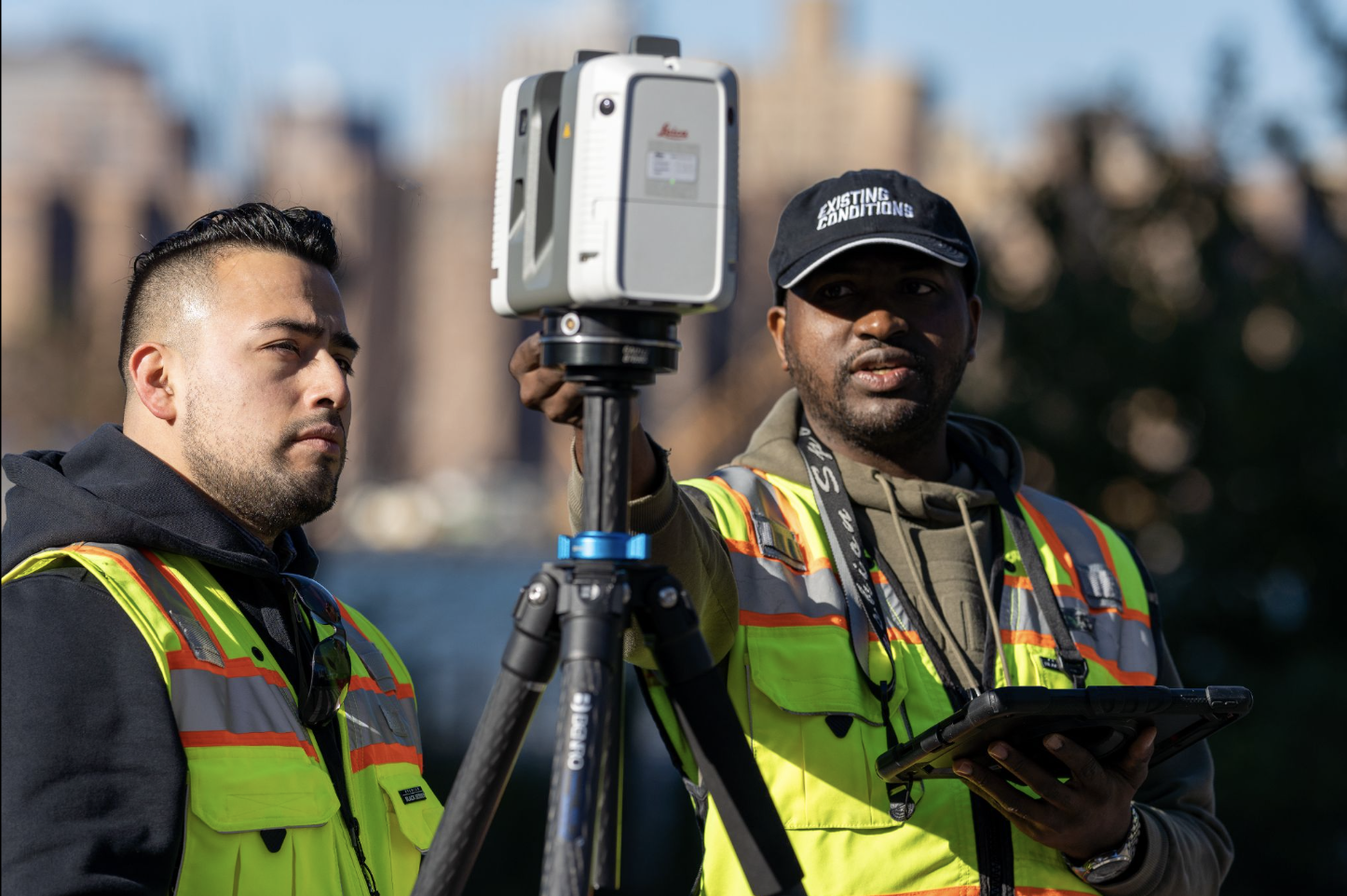
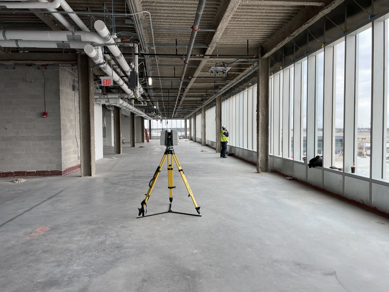
Project Managers use professional grade Leica RTC360 and P-series laser scanners for architectural, engineering, industrial, and construction projects because they offer outstanding range, speed, and data quality.
Leica P-Series ScanStations are accurate within 2-4 mm, can tie to survey control, and have dual axis compensation to help mitigate movement and ensure level scans. The RTC360 is lighter-weight and offers more flexibility of use in the field. Our Project Managers receive formal training from the scanner manufacturer, plus weeks of classroom and field instruction from an experienced scan technician, so they can employ these tools to their full capabilities.
As discussed earlier, most 3D laser scanners work along similar lines. They look a bit like movie cameras on tripods, but they actually contain both a highly sensitive and accurate laser (LiDAR) and a panoramic HD camera to capture the space in real time.
The laser cannot cause harm to the building, people, or animals. It rotates at super-high speed inside its housing, capturing as many as 2 million data points per second, depending on the necessary scan resolution. As the beam interacts with the features of the space relative to the beam, it is recorded as a data point.
The collected data points of a scanned space are called a point cloud. The more points you capture and record, the higher the scan’s resolution and accuracy. But as previously discussed, the resolution is dependent upon the purpose of the scan.
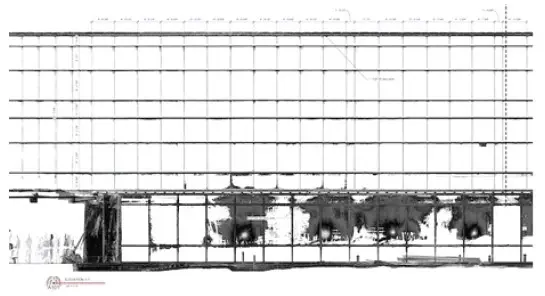
A terrestrial laser scanner like the Leica RTC360 is capable of complete 360-degree rotation, so it can survey an entire space from a single position or station. However, because the laser is limited by line of sight, it is important to scan multiple stations to ensure you capture every necessary part of a space.
Scan & HD Photography In One
Once the Project Manager has scanned the area, the camera can then be automatically tasked with capturing an almost instantaneous panoramic high definition (HD) photo of the space. The RTC360 can create an HD photo in 60 seconds once the laser is finished with its work. And thanks to Leica’s visual inertia system, when the scanner is repositioned, the laser and camera can adjust automatically to integrate the data from every new location into the survey.
As each position’s scan is completed, a reduced data set that includes a point cloud and image is made instantly available to the Project Manager via a tablet or mobile device where he can then annotate, tag, add additional eld photos, and even record audio messages on to document his eld notes on the point cloud survey, so that nothing is lost or left to memory.
Once the full survey is finished, the higher resolution point cloud, photos, and the Project Manager’s notes are then sent to our talented and skilled engineers who register and process the point cloud data into whatever variety of deliverable best suits your needs.
Existing Conditions 3D Laser Scanning Services
Over the past 27 years, we have measured, documented, and modeled over 10,000 buildings spanning over 700 million square feet across the United States, establishing ourselves as an industry leader in 3D laser scanning. Architects, builders, engineers, developers, and facility managers, trust us to deliver digital representations of the as-built environment with unparalleled accuracy and efficiency. Our dedicated Project Managers provide fast and accurate 3D laser scanning services and drone imagery services, and expert CAD and BIM technicians create custom, detailed deliverables. Our greatest reward remains delivering superior-quality scan-to-BIM work and knowing we played a vital role in our clients’ unique and historic projects.
Contact us today for a free project estimate.
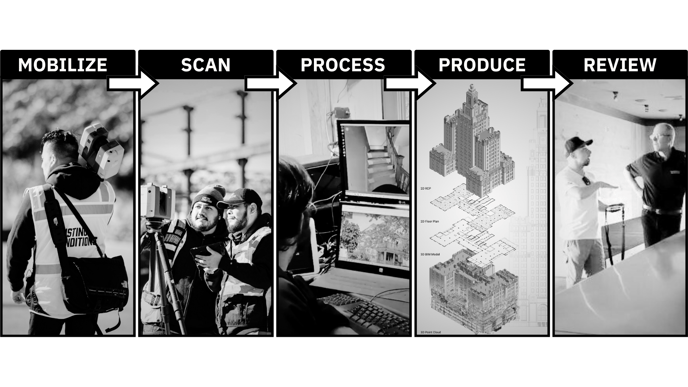
3D Laser Scanning Project Delivery Schedule
At Existing Conditions, our clients include architects, builders, engineers, developers, facility managers, owners, and other construction and real estate industry professionals. As you can imagine, each discipline works with existing conditions drawings in different ways for different projects. As a result, we have worked on thousands of unique projects and understand how to create an appropriate plan to set our clients up for success.
By using the latest 3D laser scanning technologies, proprietary workflows, and a highly trained staff, we have built an expansive portfolio of more than 10,000 buildings over the past 27 years. We're passionate about our work, and it shows. View our portfolio here.
All of our personnel have worked together for years on buildings in virtually every industry and at every scale. And most importantly, our team members have worked for, and have been trained by, building industry professionals. We understand the language of buildings, how they are constructed, and ultimately how to deliver relevant, accurate, and vital information to our clients.
Existing Conditions has thrived as a 3D laser scanning company for nearly two and a half decades because we've taken a very long term view of how we serve our clients, working to help determine exactly what is needed to get the job done right. We're very happy being a part of the client's team – providing as-built drawings and 3D BIM models of superior quality and at a reasonable speed that will allow us to do a good job. For a modest cost early on, our service helps clients avoid significant unpleasantness later on in their projects due to change orders, rework, and construction delays. Unfortunately, without accurate existing conditions drawings, these risks remain very real.
If we can't do this work better, faster, and more affordably than your internal team, then we are not living up to our mission at Existing Conditions.
With each project, we provide a 3D laser scanning delivery schedule breakdown that details the milestones that track the successful delivery of your project. This typically includes mobilization, field work, data processing, production of deliverables, and ongoing post-delivery project support.
You can count on us to work hard to deliver for you.
The dates that we provide to you are carefully determined estimates based on our experience with similar projects.
While we strive to accurately estimate project timelines in every proposal, we reserve the right to adjust milestone and delivery dates in response to unforeseen delays or changes to project requirements.
We can schedule jobs honestly and predictably because we've been doing this for 27 years. We have a large database of past delivery schedules for every type of project imaginable, which enables us to provide you with the most appropriate delivery timeline for your exact scope of work.
No matter the building type or project stage, Existing Conditions has managed reality data capture for hundreds of similar deals. Because we focus solely on the creation of accurate as-built drawings and 3D BIM models, we are able to create a delivery schedule that suits your exact needs.
We're a problem solver, not a problem creator
A huge part of our success for 27 years has been the partnerships we build with our clients, which have been fostered through clear communication. We listen carefully to our clients to understand exactly what they need. In turn, it is also important that our clients verify that we did not miss the mark.
When you receive our quote, please carefully review our proposed Delivery Schedule.
We pride ourselves on functioning as "a known quantity" in an industry with innumerable uncertainties. Our clients consider Existing Conditions as an extension of their own teams. They leverage our experience, equipment, and expertise.
Our personnel have backgrounds in architecture, construction, development, brokerage, and real estate finance. With that foundation, we are able to "speak your language" and deliver you exactly what you need for your specific project demands.
Having scanned and modeled thousands of buildings in virtually every asset class across the globe, we have built an unmatched portfolio and have thousands of repeat clients that trust us to meet their standards and specifications. Our brand is defined by competence, honesty, and performance.
The main factors that determine our schedule
Every project is unique – and our work is driven by your scope. For instance, measuring and modeling a Gothic cathedral is a very different professional exercise than creating as-built drawings for an empty warehouse. And even with two similarly-sized warehouse buildings, a client that is marketing their building for lease may have very different needs than a client who needs as-built drawings for an intensive renovation of their warehouse.
That being said, there are a number of basic variables that determine the time it takes to produce an accurate set of existing conditions drawings. They include:
- Location
- Square footage
- Building access and occupancy
- Days required on site
- Types of 2D CAD drawings needed
- Level of detail required
- Complexity of the interior spaces and exterior facade
- Number of recommended scanning personnel
- Tools required to properly measure the space
- Other client requirements, such as overnight or weekend scanning
Our consultative sales process allows our team to fully understand your building and your project needs in order to get you precisely what you need – nothing more, nothing less. This ensures that projects are delivered quickly and that your costs are reasonable, allowing you to do your best work, no matter if you are an architect, consultant, builder, broker, or other building industry professional.
Responsive to your specific needs
We can also execute projects in multiple stages to meet your specific project requirements. For instance, some clients will ask us to measure and model one area of a building in an initial phase and revisit the remainder of the building once project financing is fully secured.
In other scenarios, a client may only initially require a set of schematic "core and shell" floor plans. Perhaps they are performing their due diligence on an acquisition and have not yet closed on the property. Or maybe their project requires subsequent funding to complete the project. For these situations, Existing Conditions can produce an initial set of drawings from our laser scan data, and then revisit the same scan data later on to produce more detailed drawings suitable for the final stages of a deal. If the client wants to add additional items to their scope of work a month or a year later, we've typically already collected the measurements required to produce the requested drawings.
This approach allows us to minimize the need for additional site visits and mobilization costs, and speaks to the value of getting the job done right the first time while on site. Our flexibility is a major strength – we are your partner and want the best for your project, no matter the scope of work.
If we have sent you a quote that is beyond your budget or required scope, just let our team know! Our proposal is not carved in stone – we will work with you to meet your budget, schedule, and scope requirements. Our pricing is transparent and predictable – no hidden fees, no extras, and no unpleasant surprises when you receive your invoice upon delivery.
Existing Conditions 3D Laser Scanning Services
Over the past 27 years, we have measured, documented, and modeled over 10,000 buildings spanning over 700 million square feet across the United States, establishing ourselves as an industry leader in 3D laser scanning. Architects, builders, engineers, developers, facility managers, trust us to deliver digital representations of the as-built environment with unparalleled accuracy and efficiency. Our dedicated Project Managers provide fast and accurate 3D laser scanning services and drone imagery services, and expert CAD and BIM technicians create custom, detailed deliverables. Our greatest reward remains delivering superior-quality scan-to-BIM work and knowing we played a vital role in our clients’ unique and historic projects.
3D Laser Scanning: The Safe Way to Visualize Your Projects
Existing Conditions has many construction-grade 3D laser scanners in our inventory of equipment. The scanners are "Class 1,” which means they are no more powerful than a supermarket checkout laser’s scanner. These lasers pose no harm to people or buildings. The scanner hardware itself is portable and quiet. It can be used around people so there will not be any need to limit your on-site operations.
Can Existing Conditions Scan Occupied Buildings?
Yes, it is both safe and entirely possible to scan occupied buildings. 3D laser scanning is a safe process used in the building industry for about 20 years. We also use small, professional, uniformed crews who are discrete and do not disturb tenants or clients.
Learn More About the Laser Scanning Process
Our operations teams would be happy to give a short introduction on the scanning process to your site representatives before beginning their work on your premises.
Contact us today to learn more.
Existing Conditions 3D Laser Scanning Services
Over the past 27 years, we have measured, documented, and modeled over 10,000 buildings spanning over 700 million square feet across the United States, establishing ourselves as an industry leader in 3D laser scanning. Architects, builders, engineers, developers, and facility managers, trust us to deliver digital representations of the as-built environment with unparalleled accuracy and efficiency. Our dedicated Project Managers provide fast and accurate 3D laser scanning services and drone imagery services, and expert CAD and BIM technicians create custom, detailed deliverables. Our greatest reward remains delivering superior-quality scan-to-BIM work and knowing we played a vital role in our clients’ unique and historic projects.
A Complete List of Existing Conditions Deliverables
We tailor our deliverables to your specific project needs. Please take a look at our list of deliverables below. If you don't see what you need, please reach out – we can create customizable deliverables upon request.
Our field crews are comprised of professionals who uphold high safety standards. Many of our Operations Associates hold certifications in asbestos handling, possess OSHA Certificates, and undergo construction safety training. Additionally, we have licensed drone pilots on staff, equipped with cutting-edge aerial surveying tools.
Areas we typically survey include architectural floor plans, exterior elevations, reflected ceiling plans, roof plans, bathroom and kitchen cores, square footage calculations, and more. We also offer drone survey services, interior MEP/FP documentation, and expert consultation and support.
What Deliverables Can Existing Conditions Provide?
- 3D Point Clouds
- 2D CAD Drawings, Floor Plans, Exterior Elevations, Building Sections, Reflected Ceiling Plans, and more
- 3D BIM Models
- 3D Mesh Models
- TruView Virtual Site Visit
- 3D Photogrammetry & 3D Virtual Tours
- Aerial Photogrammetry and Video
- Orthomosaic Maps and Orthomosaic Images
- Custom Analysis and Calculations
What Can Existing Conditions 3D Laser Scan?
3D laser scanning can essentially capture any site that requires high accuracy for documentation, analysis, or virtual exploration. 3D laser scanning can be used to capture a wide range of buildings and sites, including:
- Construction Sites
- Architecture, Adaptive Reuse
- Historic Buildings, Museums, Churches & Monuments
- Agricultural Facilities
- Industrial, Manufacturing & Distribution Facilities
- Office Buildings & Commercial Buildings
- Oil & Gas Facilities
- Power Plants & Process Plants
- Real Estate
- Recreation, Retail & Restaurant Locations
- Energy & Utilities
- Stadiums, Arenas, Theaters & Convention Centers
- Telecommunication Sites
- Government, Defense & Military Sites
- Schools & Universities
- Hospitals, Healthcare & Pharmaceutical Facilities
- Subsurface Utility & Concrete Markings
- HVAC & MEP (Mechanical, Electrical, and Plumbing) Features
- Water & Wastewater Treatment Plants
- Accident Sites & Incident Scenes
- 3D Tree Architecture
- Residential Properties, Homes & Apartments
- Infrastructure Projects, Bridges, Tunnels, Airports
Visit our portfolio, or contact us to connect with a member of our team.
About the Existing Conditions Team
Established in 1997, Existing Conditions was founded with a mission to revolutionize the field of documentation by offering unparalleled accuracy, efficiency, and cost-effectiveness. Over the years, we've remained steadfast in our commitment to these principles, continually pushing the boundaries of reality capture technologies to provide the most comprehensive building documentation available.
Our dedicated team brings a wealth of experience to the table. Our field crews are seasoned professionals who uphold rigorous safety standards at every job site. Many of our Operations Associates hold certifications in asbestos handling, possess OSHA Certificates, and undergo construction safety training.
Furthermore, we boast a team of licensed drone pilots equipped with cutting-edge aerial surveying tools, ensuring that we meet your requirements with precision and efficiency.
At Existing Conditions, our track record speaks for itself. We prioritize accuracy, safety, and efficiency in every project we undertake, and our commitment to excellence is unwavering.
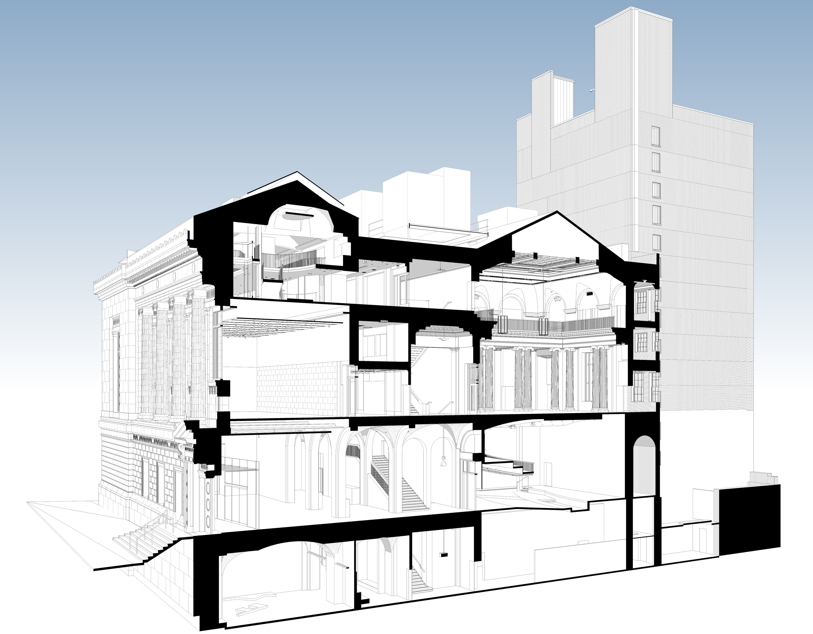
Above-Ceiling MEP Information with 3D Laser Scanning
How Existing Conditions Provides You with Above-Ceiling Information
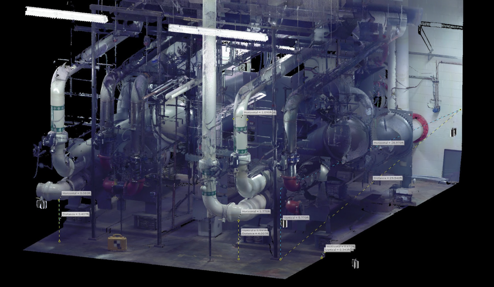
One of the biggest challenges in the renovation of an existing building is accurate documentation of the building's MEP systems. Engineering-grade 3D laser scanning can be a vital part of this process. Even if a team has a historic set of as-built drawings, it’s likely that they'll find that the existing systems were not built 100% as originally designed, or additional systems may have been installed over the years. Unfortunately, it’s not easy to produce accurate measurements in crawl spaces or above ceiling tiles.
.jpeg)
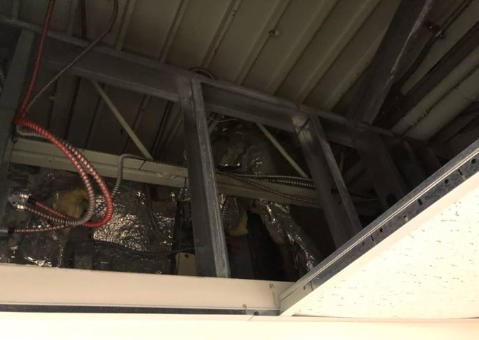
It is important to understand the unique complexities and challenges involves with gathering above-ceiling information. Above-ceiling MEP scanning and modeling requires a level of effort and coordination above and beyond most other project scopes. Existing Conditions will not be responsible for removal and replacement of ceiling tiles or other elements. Typically, the quality of the information we gather is proportional to the amount of ceiling tiles that can be removed by the owner's team. It will be the responsibility of the building owner and property manager to provide safe and efficient access for Existing Conditions field operations crews to gather the required information. If you have any questions about the requirements for this particular scope of work, please reach out to us early and often – we are here to help!
.jpeg)
Existing Conditions can help you overcome these challenges with our above-ceiling documentation services. Our teams use 3D laser scanning to quickly and accurately capture infrastructure located in hard-to-reach plenum spaces, including visible structural, MEP, and HVAC system elements. We take that data and process it using the Existing Conditions Cloud, allowing us to “connect the dots” between what the scanner could see and what was hidden to create an accurate MEP as-built point cloud model. Our team can then model elements like pipes and ducts and convert them to Building Information Modeling (BIM) object families. When converted to a BIM, the point cloud model allows engineers and architects to quickly access and analyze as-built conditions. If a retrofit design has already been proposed, Existing Conditions can create a 3D BIM model to perform 3D clash analyses, helping to resolve problems before construction begins, saving both time and money.
.jpeg)
Existing Conditions 3D Laser Scanning Services
Over the past 27 years, we have measured, documented, and modeled over 10,000 buildings spanning over 700 million square feet across the United States, establishing ourselves as an industry leader in 3D laser scanning. Architects, builders, engineers, developers, and facility managers, trust us to deliver digital representations of the as-built environment with unparalleled accuracy and efficiency. Our dedicated Project Managers provide fast and accurate 3D laser scanning services and drone imagery services, and expert CAD and BIM technicians create custom, detailed deliverables. Our greatest reward remains delivering superior-quality scan-to-BIM work and knowing we played a vital role in our clients’ unique and historic projects.
Contact us today for a free project estimate.
Academic Building 3D Laser Scanning Services
Our team boasts an extensive and illustrious track record with decades of collective experience in delivering precise building documentation and 3D laser scanning services tailored specifically for academic buildings. This wealth of knowledge and proficiency sets us apart as industry leaders in this specialized field.
Historic and High-Profile Academic Projects
Over the years, we've had the honor of contributing to some of the most historic and high-profile academic projects across the United States. Our portfolio includes landmark institutions renowned for their significance in academia, architecture, and history. These projects exemplify our commitment to excellence and our ability to meet the exacting standards demanded by such prestigious endeavors.
Understanding the Unique Demands
Academic buildings present unique challenges and requirements that demand a specialized approach. We fully comprehend the intricacies involved in documenting these spaces, which often combine cutting-edge technology with historic preservation. Our experience equips us with the insight to navigate these complexities effectively.
What It Takes to Get the Job Done Right
Getting the job done right in the realm of academic building documentation demands more than just technical expertise. It requires a profound understanding of the educational environment, the preservation of institutional legacies, and the integration of modern advancements. Our team possesses this multifaceted understanding, ensuring that our work aligns seamlessly with the educational mission, architectural heritage, and future aspirations of academic institutions.
3D Laser Scanning Services for Academic Buildings
Existing Conditions provides as-built documentation services for schools, universities, colleges, and campuses to support site renovations and upgrades. From entire schools to campus buildings to stadiums and mechanical rooms, Existing Conditions has extensive experience 3D laser scanning schools, universities, colleges, and institutions. Existing Conditions 3D laser scanning services document the exact architectural, structural, and MEP system layout and dimensions to support site renovations and upgrades, delivering as-built data to coordinate construction plans, reduce change orders, and save time.
Existing Conditions' Project Managers use industry-leading Leica survey-grade laser scanners to capture accurate existing site conditions in the form of a point cloud. Our in-house Mapping & Modeling Team can transform those point clouds into customized 2D CAD drawings, 3D BIM models, 3D mesh models, TruViews, and 3D virtual tours at any level of detail for visualization, analysis, design, construction, and renovation.
Existing Conditions brings expertise in many areas, including engineering, architecture, information technology, and construction. Having this combination of knowledge is integral to providing your team with the accurate data, drawings, and models that will save time and money on your next project or renovation.
Our team boasts an extensive legacy of expertise in providing precise building documentation for preparatory schools and high schools. Over the course of several decades, we've had the honor of contributing our 3D laser scanning services to some of the most renowned and prestigious academic projects in the United States. This rich experience has equipped us with an in-depth understanding of the unique demands and intricacies associated with academic building documentation.
Preparatory schools and high schools play a vital role in shaping the educational landscape, and their facilities often hold historical, architectural, and functional significance. Our team's proficiency extends to accurately capturing and documenting these unique attributes, ensuring that the essence and integrity of these educational institutions are preserved in our documentation.
The educational sector demands a meticulous approach to building documentation, encompassing everything from historic preservation to modern educational facility development. Our seasoned professionals are well-prepared to address the diverse needs and challenges posed by academic projects, enabling us to consistently deliver results of the highest caliber.
At the heart of our work lies an unwavering commitment to excellence, ensuring that your academic building project receives the comprehensive and precise documentation it requires. When entrusting us with your school, university, college, or campus building documentation needs, you can have confidence in our decades of 3D laser scanning experience and expertise, knowing that we have what it takes to get the job done right.
Existing Conditions 3D Laser Scanning Services
Over the past 27 years, we have measured, documented, and modeled over 10,000 buildings spanning over 700 million square feet across the United States, establishing ourselves as an industry leader in 3D laser scanning. Architects, builders, engineers, developers, and facility managers, trust us to deliver digital representations of the as-built environment with unparalleled accuracy and efficiency. Our dedicated Project Managers provide fast and accurate 3D laser scanning services and drone imagery services, and expert CAD and BIM technicians create custom, detailed deliverables. Our greatest reward remains delivering superior-quality scan-to-BIM work and knowing we played a vital role in our clients’ unique and historic projects.
Existing Conditions 2D CAD Drawing & 3D BIM Model Deliverables for Academic Buildings
Architectural Layouts: Floor plans, elevations, sections, and RCPs showing the current configuration of walls, doors, windows, and more to document a building’s layout.
Structural Details: Up to date information about load-bearing walls, beams, columns, and foundation systems to understand a building's structural integrity and constraints.
Building Dimensions: Accurate measurements of all spaces, including heights, widths, and depths to avoid discrepancies during design.
MEP Systems: Location and layout of HVAC systems, electrical wiring, plumbing, and fire protection systems for redesign or upgrades.
Material Specifications: Details on existing materials used in walls, floors, roofs, and finishes for construction or renovation planning.
Condition Assessments: Documentation of the building’s current condition, identifying issues such as cracks, leaks, or wear that may require attention.
Contact us today for a free project estimate.
Academic Campus 3D Laser Scanning Services
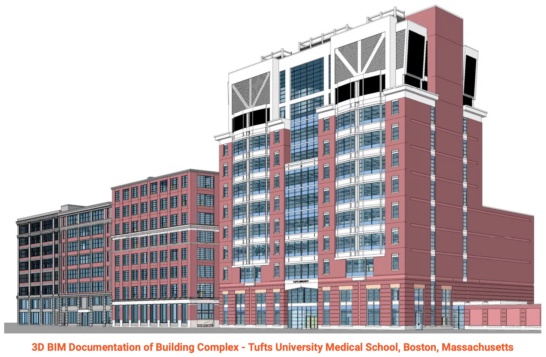
To make campuses less intimidating and easier to navigate, schools have been creating interactive 3D maps for students and visitors. The most accurate and effective way of doing this is to use Building Information Modeling (BIM) documentation and 3D laser scanning.
It’s no surprise major institutions like Tufts University regularly leverage this technology and reap a number of benefits from doing so, including:
- Precise digital records and 3D representations of the campus
- Improved accuracy
- Minimally invasive process: no need for shut downs and interruptions
- Incredibly fast results
- Provides you with as-built dimensions for renovations or remodels
Using Existing Condition’s 3D laser scanning technology, you get so much more than point to point campus measurements. In fact, you get billions of points of data that are turned into a colorized, interactive three-dimensional representation of the campus.
We've had the privilege to work on some of the most historic and high-profile academic projects in the United States, and we know what's required to get the job done right.
3D Laser Scanning Services for Schools, Universities, Colleges, and Campuses
Existing Conditions provides as-built documentation services for schools, universities, colleges, and campuses to support site renovations and upgrades. From entire schools to campus buildings to stadiums and mechanical rooms, Existing Conditions has extensive experience 3D laser scanning schools, universities, colleges, and institutions. Existing Conditions 3D laser scanning services document the exact architectural, structural, and MEP system layout and dimensions to support site renovations and upgrades, delivering as-built data to coordinate construction plans, reduce change orders, and save time.
Existing Conditions' Project Managers use industry-leading Leica survey-grade LiDAR laser scanners to capture accurate existing site conditions in the form of a point cloud. Our in-house Mapping & Modeling Team can transform those point clouds into customized 2D CAD drawings, 3D BIM models, 3D mesh models, TruViews, and 3D virtual tours at any level of detail for visualization, analysis, design, construction, and renovation.
Existing Conditions brings expertise in many areas, including engineering, architecture, information technology, and construction. Having this combination of knowledge is integral to providing your team with the accurate data, drawings, and models that will save time and money on your next project or renovation.
Our team boasts an extensive legacy of expertise in providing precise building documentation for preparatory schools and high schools. Over the course of several decades, we've had the honor of contributing our 3D laser scanning services to some of the most renowned and prestigious academic projects in the United States. This rich experience has equipped us with an in-depth understanding of the unique demands and intricacies associated with academic building documentation.
Preparatory schools and high schools play a vital role in shaping the educational landscape, and their facilities often hold historical, architectural, and functional significance. Our team's proficiency extends to accurately capturing and documenting these unique attributes, ensuring that the essence and integrity of these educational institutions are preserved in our documentation.
The educational sector demands a meticulous approach to building documentation, encompassing everything from historic preservation to modern educational facility development. Our seasoned professionals are well-prepared to address the diverse needs and challenges posed by academic projects, enabling us to consistently deliver results of the highest caliber.
At the heart of our work lies an unwavering commitment to excellence, ensuring that your academic building project receives the comprehensive and precise documentation it requires. When entrusting us with your school, university, college, or campus building documentation needs, you can have confidence in our decades of 3D laser scanning experience and expertise, knowing that we have what it takes to get the job done right.
Existing Conditions 3D Laser Scanning Services
Over the past 27 years, we have measured, documented, and modeled over 10,000 buildings spanning over 700 million square feet across the United States, establishing ourselves as an industry leader in 3D laser scanning. Architects, builders, engineers, developers, and facility managers, trust us to deliver digital representations of the as-built environment with unparalleled accuracy and efficiency. Our dedicated Project Managers provide fast and accurate 3D laser scanning services and drone imagery services, and expert CAD and BIM technicians create custom, detailed deliverables. Our greatest reward remains delivering superior-quality scan-to-BIM work and knowing we played a vital role in our clients’ unique and historic projects.
Existing Conditions 2D CAD Drawing & 3D BIM Model Deliverables
Architectural Layouts: Floor plans, elevations, sections, and RCPs showing the current configuration of walls, doors, windows, and more to document a building’s layout.
Structural Details: Up to date information about load-bearing walls, beams, columns, and foundation systems to understand a building's structural integrity and constraints.
Building Dimensions: Accurate measurements of all spaces, including heights, widths, and depths to avoid discrepancies during design.
MEP Systems: Location and layout of HVAC systems, electrical wiring, plumbing, and fire protection systems for redesign or upgrades.
Material Specifications: Details on existing materials used in walls, floors, roofs, and finishes for construction or renovation planning.
Condition Assessments: Documentation of the building’s current condition, identifying issues such as cracks, leaks, or wear that may require attention.
Airport 3D Laser Scanning Services
With decades of experience, our team at Existing Conditions excels in providing 3D laser scanning, as-built drawing, and 3D BIM modeling services for airports, including terminal buildings, control towers, hangars, lounges, food service areas, restaurants, emergency services, security, baggage handling, parking lot structures, and more. Our commitment to accuracy and comprehensive knowledge of aviation-related structures ensures that we deliver results that meet the highest standards.
Unparalleled Expertise:
Working on airport projects demands a unique set of skills and expertise, given the critical nature of aviation infrastructure. We understand the intricacies of airport design and construction, enabling us to capture essential data accurately and efficiently.
Historic Significance:
Our portfolio proudly includes historic and high-profile aviation projects. These experiences have honed our ability to navigate the complexities of preserving and documenting structures with historical significance while meeting contemporary requirements.
What We Offer:
- Accurate As-Built Documentation: We provide precise and comprehensive as-built documentation of airport facilities, ensuring that every detail is captured for various purposes, from maintenance to expansion.
- Efficiency and Reliability: Our team's efficiency ensures that projects are completed on time and within budget. We take pride in our ability to deliver work of superior quality consistently.
- Tailored Solutions: Recognizing that each airport project is unique, we tailor our services to meet your specific needs and scope. Our goal is to provide you with the data and insights required to make informed decisions.
- Comprehensive Services: Our expertise encompasses various aspects of airport infrastructure, from terminals and runways to hangars and support facilities. We are equipped to handle the diverse needs of aviation projects.
- Adherence to Regulations: We are well-versed in the regulations and standards governing airport design and construction, ensuring that our as-built documentation aligns with industry requirements.
When you choose Existing Conditions for your airport as-built documentation needs, you're enlisting a team with a deep understanding of the aviation industry's demands. We are dedicated to delivering superior results and contributing to the success of your aviation projects.
Existing Conditions 3D Laser Scanning Services
Over the past 27 years, we have measured, documented, and modeled over 10,000 buildings spanning over 700 million square feet across the United States, establishing ourselves as an industry leader in 3D laser scanning. Architects, builders, engineers, developers, and facility managers, trust us to deliver digital representations of the as-built environment with unparalleled accuracy and efficiency. Our dedicated Project Managers provide fast and accurate 3D laser scanning services and drone imagery services, and expert CAD and BIM technicians create custom, detailed deliverables. Our greatest reward remains delivering superior-quality scan-to-BIM work and knowing we played a vital role in our clients’ unique and historic projects.
Architects
Existing Conditions: Empowering Architects Worldwide
For decades, Existing Conditions has been at the forefront of empowering architects across the globe with unparalleled situational awareness. Our dedication to delivering precise, real-world data has revolutionized the way architects approach their projects, streamlining processes, and enhancing project outcomes.
Architects Harnessing Construction-Grade Laser Scanning and BIM
Architects today harness the power of construction-grade laser scanning and Building Information Modeling (BIM) to accomplish their objectives efficiently and effectively. Here are some of the key ways in which architects leverage these cutting-edge technologies:
- Rapid Project Delivery: By employing construction-grade 3D laser scanning and Building Information Modeling (BIM), architects can expedite project timelines significantly. The precise data provided by laser scanning allows for quicker decision-making and design adjustments, ultimately resulting in the delivery of projects in a fraction of the time it once took.
- Cost and Resource Efficiency: These technologies enable architects to optimize resource allocation and reduce project costs. The accuracy of 3D laser scanning minimizes the need for costly rework and adjustments, making efficient use of both time and resources.
- Meeting Tight Deadlines: With the ability to swiftly capture and analyze real-world data, architects can accommodate clients with tight deadlines. 3D laser scanning and BIM empower architects to work efficiently and deliver results promptly, ensuring client satisfaction.
- Reduced RFIs: The comprehensive data provided by 3D laser scanning and BIM leads to fewer Requests for Information (RFIs). Architects have access to detailed, real-world information, reducing ambiguity and streamlining communication with contractors and other stakeholders.
- Enhanced Client Communication: These technologies facilitate improved client understanding by allowing architects to visually communicate design intent with precision. Clients can better grasp the proposed concepts and designs, leading to smoother decision-making processes.
- Mitigating Design Errors: Architects utilize 3D laser scanning and BIM to minimize the risk of costly design errors. Accurate data capture and modeling reduce the chances of oversights or inaccuracies, ensuring that projects proceed smoothly.
- Streamlined Workflows: Ultimately, architects benefit from these technologies by experiencing fewer headaches and interruptions in their project workflows. The integration of 3D laser scanning and BIM into their processes enhances efficiency, reduces complications, and fosters a smoother project experience.
At Existing Conditions, we take pride in empowering architects with the tools and data they need to excel in their projects. We remain committed to advancing the field and ensuring that architects can leverage the full potential of construction-grade 3D laser scanning and BIM to achieve remarkable results.
Existing Conditions 3D Laser Scanning Services
Over the past 27 years, we have measured, documented, and modeled over 10,000 buildings spanning over 700 million square feet across the United States, establishing ourselves as an industry leader in 3D laser scanning. Architects, builders, engineers, developers, and facility managers, trust us to deliver digital representations of the as-built environment with unparalleled accuracy and efficiency. Our dedicated Project Managers provide fast and accurate 3D laser scanning services and drone imagery services, and expert CAD and BIM technicians create custom, detailed deliverables. Our greatest reward remains delivering superior-quality scan-to-BIM work and knowing we played a vital role in our clients’ unique and historic projects.
If you'd like to learn more, visit our portfolio, or contact us to connect with a member of our team.
Architectural Term Abbreviations
A Cheat Sheet for Deciphering Architectural Abbreviations and Symbols
Architectural diagrams and drawings such as floor plans, reflected ceiling plans, and elevations are generally pretty self-explanatory, but the intricate details can be quite complex. It can be challenging to decipher the meaning of specific abbreviations or symbols used in these diagrams.
To simplify the process, we have compiled a cheat sheet that outlines many of the commonly used abbreviations and symbols:
- ACT -- Acoustic Ceiling Tile
- AFF -- Above Finished Floor
- BOB -- Bottom of Beam
- BOD -- Bottom of Deck
- BSMT -- Basement
- CH -- Ceiling Height
- CIP -- Cast In Place
- CL -- Centerline
- CLG -- Ceiling
- CMU -- Concrete Masonry Unit
- COL -- Column
- CONC -- Concrete
- DBL -- Double
- DEMO -- Demolish or Demolition
- DIM -- Dimension
- DIMS -- Dimensions
- DR -- Door
- DWG -- Drawing or AutoCAD file
- EL -- Elevation
- ELEC -- Electrical
- ELEV -- Elevator or Elevation
- EXIST -- Existing
- FF -- Finished Face or Finished Floor
- FFL -- Finished Floor Level
- FL -- Floor Level
- FLR -- Floor
- GWB -- Gypsum Wall Board
- HVAC -- Heating, Ventilating, and Air Conditioning
- INT -- Interior
- MAX -- Maximum
- MECH -- Mechanical
- MEP -- Mechanical, Electrical, and Plumbing
- MO -- Masonry Opening
- MIN -- Minimum
- NIC -- Not in Content
- OC -- On Center
- PC -- Point Cloud
- PNT -- Paint or Painted
- RCP -- Reflected Ceiling Plan
- RM -- Room
- SD -- Smoke Detector
- TEL -- Telephone
- TELE -- Telephone
- TEL/DATA -- Telephone/Data
- TO -- Top Of
- TYP -- Typical
- UTA -- Unable to Access
- WC -- Water Closet
- WH -- Water Heater
- W/ -- With
Existing Conditions 3D Laser Scanning Services
Over the past 27 years, we have measured, documented, and modeled over 10,000 buildings spanning over 700 million square feet across the United States, establishing ourselves as an industry leader in 3D laser scanning. Architects, engineers, builders, and developers trust us to deliver digital representations of the as-built environment with unparalleled accuracy and efficiency. Our dedicated Project Managers provide fast and accurate 3D laser scanning services and drone imagery services, and expert CAD and BIM technicians create custom, detailed deliverables. Our greatest reward remains delivering superior-quality scan-to-BIM work and knowing we played a vital role in our clients’ unique and historic projects.
Assisted Living Properties 3D Laser Scanning Services
With decades of dedicated experience, our team excels in providing meticulous as-built documentation for assisted living properties. We consider it an honor to have contributed to some of the most significant assisted living projects in the United States, and we possess a deep understanding of the exacting standards needed for success in this field.
Caring for the Elderly: Assisted living properties play a vital role in providing care and support to the elderly. Our commitment to accuracy extends to ensuring that these properties are documented with the utmost care and consideration for their residents.
Accessibility Focus: We recognize the importance of accessibility and safety in assisted living facilities. Our documentation captures every detail related to accessibility features, ensuring that residents can navigate their living spaces comfortably.
Healthcare Compliance: Assisted living properties often have healthcare components. We are well-versed in documenting these facilities in compliance with healthcare regulations, providing peace of mind to operators and residents alike.
Historic Significance: Some assisted living properties may have historical significance. We take pride in preserving the historical aspects of these properties while ensuring that they meet contemporary standards.
Respectful Documentation: Our approach to documenting assisted living properties is characterized by respect and empathy. We understand the importance of these spaces and strive to capture their essence while maintaining privacy and dignity for residents.
Experienced Specialists: Our team includes specialists with extensive experience in documenting assisted living properties. Their expertise ensures that every aspect of these properties is accurately recorded.
When it comes to precise building documentation for assisted living properties, our team's wealth of experience and unwavering commitment ensure that the job is executed to the highest standards. We take pride in contributing to the well-being and comfort of assisted living residents across the nation.
Autodesk Revit Explained
Autodesk Revit is a building information modeling software for architects, landscape architects, structural engineers, mechanical, electrical, and plumbing (MEP) engineers, designers and contractors. It can be used as a very powerful collaboration tool between different disciplines in the building design sphere. It serves as a collaborative platform, fostering efficient communication among various building design professionals.
This software empowers users to create detailed 3D models of buildings, structures, and their components. It seamlessly integrates 2D drafting elements, offering a comprehensive view of projects. Crucially, Revit draws on a centralized database to provide accurate building information.
One of its significant features is 4D BIM, facilitating lifecycle management from project inception to demolition. This tool aids in planning and tracking various project stages, enhancing project management efficiency.
In essence, Autodesk Revit is an industry-standard software that streamlines the design, construction, and maintenance of structures. Its objectivity and collaborative capabilities make it an invaluable resource for professionals in the architecture and building industry.
BIM Building Information Modeling
Building information modeling (BIM) is a process supported by various tools, technologies, and contracts involving the generation and management of digital representations of physical and functional characteristics of places.
Building information models (BIMs) are computer files (often but not always in proprietary formats and containing proprietary data) which can be extracted, exchanged or networked to support decision-making regarding a built asset. The process for scanning and modeling is largely the same regardless of the size of the project.
Who Uses BIM?
BIM software is commonly utilized by architects, builders, engineers, developers, and facility managers, and many other businesses and government agencies. It's used for planning, design, construction, operations, and maintenance of not only buildings, but other diverse infrastructures including water, refuse, electricity, gas, communication utilities, roads, railways, bridges, ports, and tunnels.
Standards and Adoption of BIM
BIM has been in development since the 1970s, but beginning in the early 2000s, it has become a more widely agreed upon term. BIM standards and adoption has progressed at different rates around the world. The standards developed in the UK beginning in 2007 have formed the basis of international standard ISO 19650, launched in January 2019.
An Infinite Database
BIM has an infinite database that is part of the 3D model and items can be adjusted in 2D CAD plan, section, elevation or in schedules and it updates the rest of the model accordingly. Conveniently, this means a full scan gives you the ability to add additional scope to the deliverables without additional site visits.
Existing Conditions 3D Laser Scanning Services
Over the past 27 years, we have measured, documented, and modeled over 10,000 buildings spanning over 700 million square feet across the United States, establishing ourselves as an industry leader in 3D laser scanning. Architects, builders, engineers, developers, and facility managers, trust us to deliver digital representations of the as-built environment with unparalleled accuracy and efficiency. Our dedicated Project Managers provide fast and accurate 3D laser scanning services and drone imagery services, and expert CAD and BIM technicians create custom, detailed deliverables. Our greatest reward remains delivering superior-quality scan-to-BIM work and knowing we played a vital role in our clients’ unique and historic projects.
BIM Modeling Scope of Work & LOD
There is a lot of confusion in the industry on how to request a Building Information Model, or BIM model for short. Some may know exactly what they need and others may have just been told to get a BIM model for a project. Either way, the two most important aspects to understand when requesting a BIM model is the difference between Scope of Work and LOD (i.e. Level of Development or Design).
3D BIM Modeling and As-Built Drawings Scope of Work
At Existing Conditions, we have worked on practically every building type imaginable, and our clients include architects, builders, engineers, developers, facility managers, interior designers, historical societies, and more. Needless to say, every project is different. The one thing that all our projects have in common is a clearly-defined Scope of Work. Our proposals are custom-made for every project to make sure we get our clients exactly what they need. This is why it's important to understand how to read our Scope of Work page.
Some of our clients only need Floor Plans. Other clients require a more developed Model, which might include Exterior Elevations and RCP information. And sometimes our clients will ask us to include MEP information in the Model, understanding the added time and expense required to build MEP elements. These are only a few of the Deliverables we offer, and we can mix-and-match our deliverables to suit the needs of your project.
Although the laser scanners we deploy measure everything within line-of-sight, our modeling scope will always be limited to those Elements in those Views which are listed in the Scope of Work of our proposal.
For our clients who use 2D CAD this is an obvious distinction, but sometimes new clients who do not understand the process may ask for a "complete BIM model". This is not a useful term, because it does not specify what will, or will not, be included. For example, a BIM Model could include parametric Room data, mechanical equipment maintenance schedules, or thermal property information, but it would be unreasonable to expect this information to be included. Our expert Sales consultants will work with you to make sure that the Elements you need in the Model will be included.
3D BIM Modeling LOD (Level of Development/Design)
Level of development (LOD) is a set of specifications that gives professionals in the building industry the power to document, articulate, and specify the content of BIM effectively and clearly. Serving as an industry standard, LOD specifications allow architects, engineers, and other professionals to clearly communicate with each other about the reliability of information associated with elements in a model. This allows for faster, more efficient project execution. LOD is also used as a measure of the level of service required – it requires less labor to produce a rudimentary model at LOD 100 versus a more detailed LOD 300 model.
Below are the LOD levels of development (and estimated corresponding project phase*), as defined by the AIA Digital Practice Documents Guide:
LOD 100 - Concept Design
Model Elements may be graphically represented in the Model with a symbol or other generic representation.
LOD 200 - Schematic Design
Model Elements are generically and graphically represented within the Model with approximate quantity, size, shape, location, and orientation.
LOD 300 - Design Development
Model Elements are graphically represented within the Model with measurable quantity, size, shape, location, and orientation.
LOD 350 - Construction Documentation
Model Elements are graphically represented within the Model with measurable quantity, size, shape, location, orientation, and interfaces with adjacent or dependent Model Elements.
LOD 400 - Fabrication & Assembly
Model Elements are graphically represented within the Model with detail sufficient for fabrication, assembly, and installation.
LOD 500 - As-Built
Model Elements are graphical representations of existing or as-constructed condition developed through a combination of observation, field verification, or interpolation. The level of accuracy shall be noted or attached to the Model Element.
Existing Condition's 3D BIM Modeling Approach for LOD & Scope of Work
Our 3D BIM models at Existing Conditions are typically LOD 300, meaning that the Model Elements are graphically represented within the Model as specific objects in terms of quantity, size, shape, location, and orientation. Non-graphic information, such as fabrication, detailing information, type, or function is not attached to a LOD 300 Model. For most of our clients, this is more than enough information for their needs. And for those that need more detail, it's simply a matter of letting our team know early, in order to ensure that our work meets your expectations. Keep in mind that LOD refers to the level of development to which a single element within the Model has been brought. It does not determine what elements are or aren't included within the Model.
This is why we place most of our emphasis on the Scope of Work for a project and not the LOD. The Scope of Work is where you outline what elements will and won't be included within the Model, and in which Views those elements will be developed. After those elements and views are defined, then we can discuss what LOD is needed for different elements if it would be different than our standards LOD 300.
Please reach out to one of our team members to discuss your project today. They can help you navigate the scope of work for your next project to make sure you get exactly what you need at a great price.
*Note: project phases may not necessarily correspond with these LODs as listed. For more information, consult the Project Phases section of The AIA Digital Practice Documents Guide.
Existing Conditions 3D Laser Scanning Services
Over the past 27 years, we have measured, documented, and modeled over 10,000 buildings spanning over 700 million square feet across the United States, establishing ourselves as an industry leader in 3D laser scanning. Architects, builders, engineers, developers, and facility managers, trust us to deliver digital representations of the as-built environment with unparalleled accuracy and efficiency. Our dedicated Project Managers provide fast and accurate 3D laser scanning services and drone imagery services, and expert CAD and BIM technicians create custom, detailed deliverables. Our greatest reward remains delivering superior-quality scan-to-BIM work and knowing we played a vital role in our clients’ unique and historic projects.
Behind-Wall Information with 3D Laser Scanning Services
One of the biggest challenges in the renovation of an existing building is accurate documentation of the building's MEP systems. Engineering-grade 3D laser scanning can be a vital part of this process. Even if a team has a historic set of drawings, it’s likely that they'll find that the existing systems were not built 100% as originally designed, or additional systems may have been installed over the years. Unfortunately, it’s not easy to produce accurate measurements of the infrastructure that often exists behind the plane of a wall surface, because terrestrial laser scanning cannot see the mechanical, electrical, and plumbing equipment hidden behind a wall. This is because laser scanning is a "line of sight" tool, meaning that it captures measurements about the visible built environment, but not that which it cannot see.
If you need as-built drawings of what lies behind a wall surface, it is likely that partial or comprehensive demolition may be required. Existing Conditions will not be responsible for demolition of wall surface or other elements, but we are happy to walk you through how to manage this process effectively in regard to procuring accurate as-built drawings of behind-wall MEP/FP information.
.png)
It is important to understand the unique complexities and challenges involved with gathering behind-wall information in an existing building. Scanning and modeling partially demolished wall systems requires a level of effort and coordination above and beyond most other project scopes. Typically, the quality of the information we gather is proportional to the amount of selective demolition performed by the owner's contractor. It will be the responsibility of the building owner and property manager to provide safe and efficient access for Existing Conditions field operations crews to gather the required information.
If you have any questions about the requirements for this particular scope of work, please reach out to us – we are here to help!
Existing Conditions 3D Laser Scanning Services
Over the past 27 years, we have measured, documented, and modeled over 10,000 buildings spanning over 700 million square feet across the United States, establishing ourselves as an industry leader in 3D laser scanning. Architects, builders, engineers, developers, facility managers, trust us to deliver digital representations of the as-built environment with unparalleled accuracy and efficiency. Our dedicated Project Managers provide fast and accurate 3D laser scanning services and drone imagery services, and expert CAD and BIM technicians create custom, detailed deliverables. Our greatest reward remains delivering superior-quality scan-to-BIM work and knowing we played a vital role in our clients’ unique and historic projects.
Building Owners Benefit From 3D Laser Scanning Services
Building owners and real estate developers have long recognized the immense value of leveraging 3D laser scanning and Building Information Modeling (BIM) documentation for their properties. Esteemed companies like Winn Development, Oxford, and Hines have come to rely on this advanced technology for a multitude of benefits:
- Digital Asset Transformation: 3D laser scanning and BIM documentation empower building owners to transform their real estate holdings into digital assets rich in comprehensive information. This digitalization streamlines data accessibility and management.
- Portfolio Insights: Property owners gain portfolio-level insights that enhance asset management. This broader view of their real estate holdings facilitates more effective decision-making and optimization of their property portfolios.
- Property Improvement: With a comprehensive and accurate digital representation of their properties, owners can swiftly identify areas for improvement and make adjustments without the need for frequent site visits. This efficient approach enhances property maintenance and development.
- Unrivaled Accuracy: The precision of 3D laser scanning technology ensures that the data provided is trustworthy and highly accurate. Building owners can rely on this data, resulting in fewer complications and disruptions in the long run.
3D laser scanning and BIM documentation empower building owners to transform their real estate holdings into valuable digital assets. This technology provides insights, efficiency, and accuracy that contribute to more effective asset management, property improvement, and overall peace of mind..
Building Types That Utilize BIM Technology
Building Information Modeling (BIM) is a transformative technology that has permeated various sectors of the Architecture, Engineering, and Construction (AEC) and Commercial Real Estate (CRE) industries. Its versatility and advantages have made it indispensable in a multitude of contexts, from designing innovative office spaces to creating sustainable smart cities.
3D laser scanning can capture any site that requires high accuracy for documentation, analysis, or virtual exploration -- and can be used to create BIM model digital twins.
3D laser scanning can be used to capture a wide range of buildings and sites, including:
- Construction Sites
- Architecture, Adaptive Reuse
- Historic Buildings, Museums, Churches & Monuments
- Agricultural Facilities
- Industrial, Manufacturing & Distribution Facilities
- Office Buildings & Commercial Buildings
- Oil & Gas Facilities
- Power Plants & Process Plants
- Real Estate
- Recreation, Retail & Restaurant Locations
- Energy & Utilities
- Stadiums, Arenas, Theaters & Convention Centers
- Telecommunication Sites
- Government, Defense & Military Sites
- Schools & Universities
- Hospitals, Healthcare & Pharmaceutical Facilities
- Subsurface Utility & Concrete Markings
- HVAC & MEP (Mechanical, Electrical, and Plumbing) Features
- Water & Wastewater Treatment Plants
- Accident Sites & Incident Scenes
- 3D Tree Architecture
- Residential Properties, Homes & Apartments
- Infrastructure Projects, Bridges, Tunnels, Airports
Here are a few examples of how these industries would utilize BIM technology:
- Commercial Real Estate (CRE): BIM streamlines property management, leasing, and marketing in the commercial real estate sector.
- Aviation: In the aviation industry, BIM enhances planning and maintenance of airport infrastructure.
- Office Buildings: BIM aids in designing efficient office spaces and optimizing building systems.
- Parking Structures: BIM simplifies complex parking structure design and management.
- Retail: BIM enhances store layout design and retail facilities management.
- Smart Cities: BIM contributes to urban planning and development in smart cities.
- Stadiums: Sports and entertainment venues benefit from BIM in their design and construction.
These are just a few examples of how BIM has become an integral part of diverse industries, offering efficiency, accuracy, and innovation in building design, construction, and management.
Existing Conditions 3D Laser Scanning Services
Over the past 27 years, we have measured, documented, and modeled over 10,000 buildings spanning over 700 million square feet across the United States, establishing ourselves as an industry leader in 3D laser scanning. Architects, builders, engineers, developers, facility managers, trust us to deliver digital representations of the as-built environment with unparalleled accuracy and efficiency. Our dedicated Project Managers provide fast and accurate 3D laser scanning services and drone imagery services, and expert CAD and BIM technicians create custom, detailed deliverables. Our greatest reward remains delivering superior-quality scan-to-BIM work and knowing we played a vital role in our clients’ unique and historic projects.
California 3D Laser Scanning Services
Existing Conditions is a leading provider of 3D laser scanning services in California, helping clients to successfully complete their most complex projects with precise as-built drawings and 3D BIM models.
Behind every successful architecture, engineering, and construction project lies one crucial element – comprehensive, accurate, and up-to-date existing conditions documentation. Many clients we work with are using 3D laser scanning to reduce design errors and streamline project workflows, ensuring smoother construction, renovation, and facility management processes.
There is no better way to drive decision-making than to have accurate, intelligent, real-time reality capture data that can be shared across the project team. Existing Conditions’ clients can rest assured that design plans are accurately produced from the start, expediting fieldwork and reducing change orders, delays, and costs.
How much does 3D laser scanning cost?
What are the Benefits of 3D Laser Scanning?
• Quickly document accurate existing site conditions
• Easily integrate and share project data
• Make informed decisions with precise as-built drawings and BIM models
• Reduce design errors and change orders
• Improve project planning and construction efficiency
• Speed up project completion
.jpeg)
California 3D Laser Scanning Experience and Expertise
Our team has decades of experience when it comes to delivering accurate building documentation in California. We have been selected to work on some of the most historic and high-profile projects in the United States, and we know what's required to get the job done right. Below is a selection of relevant projects we have measured and modeled in recent years.
1. 150 California Street, San Francisco, CA
2. Community School for Creative Education, Oakland, CA
3. George Foreman Boxing Gym, Calabasas, California
4. Hintil Kuu Ka Pre-School, Oakland, CA
5. Maryland Hotel, Glendale, CA
6. Oakland Uni ed School District, Oakland, CA
7. Pacific Bell Tower, San Francisco, CA
8. Presidio, San Francisco, CA
9. Stanford Graduate School of Business, Stanford, CA
10. The PM Lounge, Fresno, CA
11. University of California, Berkeley, CA
12. Westwood Villa, Los Angeles, CA
Existing Conditions 3D Laser Scanning Services
Over the past 27 years, we have measured, documented, and modeled over 10,000 buildings spanning over 700 million square feet across the United States, establishing ourselves as an industry leader in 3D laser scanning. Architects, builders, engineers, developers, facility managers, trust us to deliver digital representations of the as-built environment with unparalleled accuracy and efficiency. Our dedicated Project Managers provide fast and accurate 3D laser scanning services and drone imagery services, and expert CAD and BIM technicians create custom, detailed deliverables. Our greatest reward remains delivering superior-quality scan-to-BIM work and knowing we played a vital role in our clients’ unique and historic projects.
Can You Move Your 3D BIM Model Into My Template?
Before Existing Conditions even sends out a project proposal, our consultative sales associates will ask if you need the work to be modeled in a specific template. Our modeling teams routinely work in client templates so that your work can begin immediately upon receiving the existing conditions 3D BIM model. If no such template is specified, we will build the 3D BIM model in our own template.
Once modeling begins, it is very hard to change templates. The best way to avoid this issue is to provide us with your Revit 3D modeling template before modeling begins.
If you have received a 3D BIM model from us, and need to move it to your template, the first step is to try to Link-Bind-Explode. Link our 3D BIM model into yours, bind the link (which will turn the model into a group), then explode the group. Pay special attention to the levels, which will effect not only the views, but the elements within them.
If this does not produce the desired result, there is another (slower) way to move the 3D BIM model to your template. You will simply need to copy everything from our 3D BIM model into your own. While this is indeed a simple process, it is slow and meticulous. Before undergoing this, be sure that both 3D BIM models have the exact same levels (in both name and elevation). We find it helps to copy (or "cut") and paste in pieces. Using worksets can help make this process smoother for large, complicated 3D BIM models.
For example, go to the Level 1 Floor Plan of the old model, and select everything you can see. Copy. Then go to the Level 1 Floor Plan of the new model, and paste. Do this for each level. If the project includes RCPs, those will need to be copied separately. Here are some other things to keep in mind:
- Make sure that pinned objects are selectable.
- Don't forget to copy the point cloud(s) to the new 3D BIM model. They are very easy to copy/paste, and the links are automatically pathed.
- Exterior Elevations (if included) will need annotations, dimensions, masking regions, etc. copied and pasted view by view.
If you do not have the time to do this, or are not confident about the process, don't worry. We will be able to do this for you, though it may impact your project budget.
Existing Conditions 3D Laser Scanning Services
Over the past 27 years, we have measured, documented, and modeled over 10,000 buildings spanning over 700 million square feet across the United States, establishing ourselves as an industry leader in 3D laser scanning. Architects, builders, engineers, developers, and facility managers, trust us to deliver digital representations of the as-built environment with unparalleled accuracy and efficiency. Our dedicated Project Managers provide fast and accurate 3D laser scanning services and drone imagery services, and expert CAD and BIM technicians create custom, detailed deliverables. Our greatest reward remains delivering superior-quality scan-to-BIM work and knowing we played a vital role in our clients’ unique and historic projects.
Can You Update Our 3D BIM Model?
Our typical workflow is to scan a building, then create an existing conditions model from scratch which will be used to document the verified conditions on site. This dedicated, Existing Conditions 3D BIM model is always available on our servers for current or future use. The project link can easily be shared to any of your teams or partners in order to collaborate with the existing conditions documentation. In addition to scanning and modeling, we offer a wide array of 3D laser scanning services to make sure you have the information you need.
While we recommend starting your projects with Existing Conditions, so that you can start accurate and stay accurate, some of our clients have models that they’ve already worked on for some time. Because a Revit model can have so many potential (often unknown) connections, any changes could risk modifying elements outside of the scope which could result in deleting or editing elements crucial to the project. Trying to verify & update portions of a working model would create uncertainty as to what is accurate, what has been updated, and what was part of the original model. For this reason, it is essential for us to have a clear point of departure between where our work ends, and where our clients' work begins.
.jpeg)
The following information covers some of the ways that we have established to help you coordinate our verified drawings with your working model:
Point Cloud Overlay
If you need to simply verify an existing space to see how much your model deviates from the existing conditions, we can overlay and align the point cloud data to a copy of your model so you can evaluate what needs to be updated. We will set up a meeting with you after the alignment to review the data and confirm the locations of the alignment. Once the data is delivered, you are able to copy and paste the point cloud from the model we deliver into your working model for use by your team. For more information about point clouds, check out this link.
Templates & Standards
One of the things that sets us apart from many other companies is the ability to work with your template and standards to help reduce the time it takes to get your team up to speed on a model. Please deliver your template and or standards before we start modeling to ensure that there are no delays. Once we've built the model, it's not easy to move the model to your template. We work in the 4 latest versions of Revit and can export to match your CAD standards if needed. Meeting with your BIM manager before modeling to review any particulars will help ensure that we meet your expectations on the project.
Model Coordination
Model Coordination is a way to sync geometry between two Revit models. This is different from survey control since it deals with the alignment of the internal origins between Revit models. This must happen at the start of a project to ensure that our model will be in-sync with your working model. Once the model coordination is complete, it will enable your teams to easily Revit link the models together or copy and paste geometry between our verified model and your working model. Please let us know if you have a model that needs coordination at the start of a project as our modeling cannot begin before the coordination has been completed.
Copy & Paste Between Models
This is one of the most powerful and simple ways of getting geometry from a verified existing conditions model into your working model, but it does require that the models have matching internal origins (see Model Coordination). As long as the copy and paste (Paste aligned to current view) is performed on the same level in each model, then the elements will align properly in your model. If dated worksets have been created for a phased delivery, then you can easily copy only the latest elements from the verified model into your working model.
Here are some of the conditions required for this to work properly:
- Models must have matching level heights to ensure that geometry is tied to the correct levels.
- The copy and paste routine must be completed at the same level in each model to ensure that the vertical alignment of the geometry matches.
- 3D model elements need to be copied and pasted separately from 2D geometry (such as text notes or dimensions) in views. If there are multiple floor plan views, each view has to be copied and pasted separately after the 3D geometry is copied over.
- Some elements may not remain connected during the copy/paste.
Dated Workset Deliveries
Project deadlines can be tight. One of the many ways we can help our clients is by providing phased deliveries on a larger project so that the priority areas can be delivered first. In these instances, we can enable worksharing in Revit and create dated worksets for New and Modified elements. This enables us to deliver specific areas once they become available and your teams can focus on the most recent updates. As new phases are completed and delivered, your teams can copy and paste the new and updated worksets into your working model to keep you on track with your deadlines. Please let us know if you need to have a phased delivery schedule on your next project.
Revit Links
To see the differences between our verified existing conditions model and your working model, it is best to utilize Revit Links. If the models have been coordinated, then the Revit link can be linked origin to internal origin in order to join the models together. Using this method is the easiest way to compare your working model to ours and to evaluate what elements may need to be updated, deleted, or replaced with elements in our verified model. Dated workset deliveries can be toggled on or off in our model to see when different updates were completed so that you only need to look for the most recent updates. Once your working model has been prepared, you can either bind the Revit link to bring the whole model into your working model, or copy and paste only the verified elements needed into your model.
Expert Consultation & Support
Once we deliver a model, it's yours. While we are happy to support our clients, post-delivery, it is essential for us to have a clear point of departure between where our work ends, and where our clients' work begins. Our official deliverables will always be provided via our Google Drive link. Upon request, we can submit models via platforms such as BIM 360 or Autodesk Construction Cloud, but we do not work externally within those systems. If you need us to adjust our project basepoint, apply survey control, rearrange Levels, or provide other significant efforts, that is something our Expert Consultation and Support team can handle to make the model-transition process easier for your team.
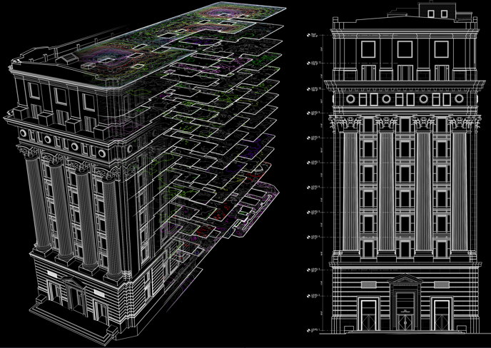
Existing Conditions 3D Laser Scanning Services
Over the past 27 years, we have measured, documented, and modeled over 10,000 buildings spanning over 700 million square feet across the United States, establishing ourselves as an industry leader in 3D laser scanning. Architects, builders, engineers, developers, and facility managers, trust us to deliver digital representations of the as-built environment with unparalleled accuracy and efficiency. Our dedicated Project Managers provide fast and accurate 3D laser scanning services and drone imagery services, and expert CAD and BIM technicians create custom, detailed deliverables. Our greatest reward remains delivering superior-quality scan-to-BIM work and knowing we played a vital role in our clients’ unique and historic projects.
Capabilities for Existing Conditions 3D Laser Scanning Services
We're comfortable working at all scales
We 3D laser scan building and projects of all sizes, from small retail and residential spaces up to entire university campuses and institution-wide documentation.
There is no project too big or too small for Existing Conditions. Whether it's the Old North Church in Boston or the entire campus of Williams College, we've completed 3D laser scanning projects of all ranges.
Have you ever walked into a space and can't imagine where to even begin getting the information you need? Maybe it's a 200+ year old building with a rabbit warren of rooms or it's a Mechanical Penthouse packed tight with MEP runs. We are in those exact types of spaces on a daily basis and all we say is, "No problem." Because of our comprehensive in-house 3D laser scanning techniques and workflows, there is no project too big or complex that we can't dissect.
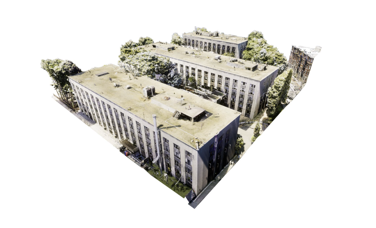
We've scanned and modeled buildings over the world
No project is too far. We have provided existing conditions documentation for projects throughout the entire world. Though there is an appropriate travel cost to do projects in remote locations, we have proven the ROI for client's time and time again.
We can work with you no matter where your project is. We routinely work throughout the United States, North America, the United Kingdom, and the European Union.
Nationwide service coverage: coast to coast, and beyond
We are a leading national provider of 3D laser scanning services and 3D BIM modeling services. Existing Conditions' clients range from small companies to large nationwide or global firms.
We are ready to mobilize to any site in the USA, usually within the lead time of only one or two days. Additionally, we have the ability to be on-site short-term or long-term, depending on our clients' needs.
Existing Conditions 3D Laser Scanning Services
Over the past 27 years, we have measured, documented, and modeled over 10,000 buildings spanning over 700 million square feet across the United States, establishing ourselves as an industry leader in 3D laser scanning. Architects, builders, engineers, developers, facility managers, trust us to deliver digital representations of the as-built environment with unparalleled accuracy and efficiency. Our dedicated Project Managers provide fast and accurate 3D laser scanning services and drone imagery services, and expert CAD and BIM technicians create custom, detailed deliverables. Our greatest reward remains delivering superior-quality scan-to-BIM work and knowing we played a vital role in our clients’ unique and historic projects.
Contact us today for a free project estimate.
Chicago 3D Laser Scanning Services
Delve into a comprehensive overview of the projects we've completed across the Chicago metropolitan area. Our team has decades of experience when it comes to delivering accurate building documentation for buildings nationwide. We have worked on some of the most historic and high-profile projects in the United States, and we know what's required to get the job done right.
Centennial Church
Utilizing the Leica RTC360 laser scanner, the Existing Conditions team scanned and documented approximately 40,000 square feet within this religious building. As part of the project scope, we also conducted scanning of the catacombs situated below ground level.
The deliverables for this project included detailed floor plans, exterior elevations, and two building sections.
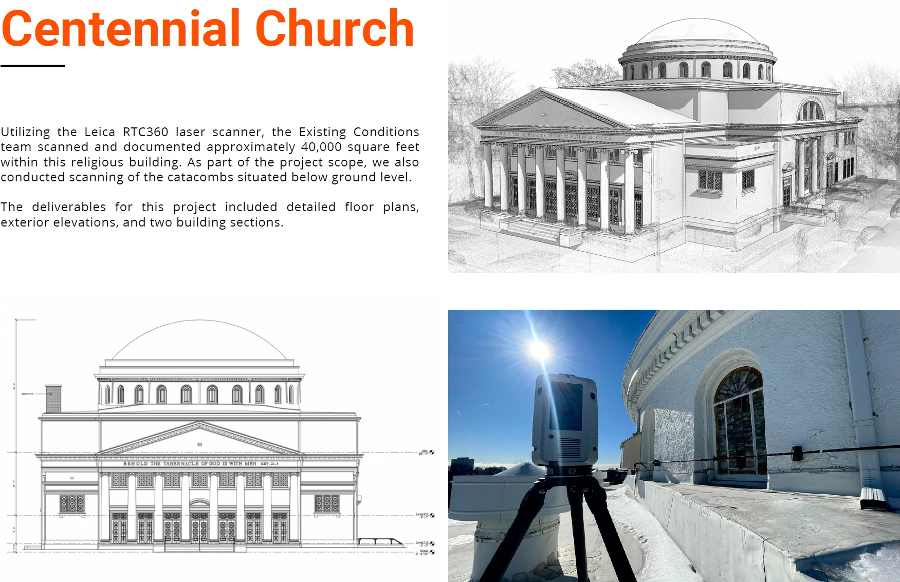
Community United Methodist Church
Selected for the task, Existing Conditions scanned and documented the Community United Methodist Church. Employing the Leica RTC360 laser scanner, capturing approximately 60,000 square feet of this property.
The comprehensive deliverables comprised accurate floor plans, exterior elevations, a roof plan, and two single-line building sections.
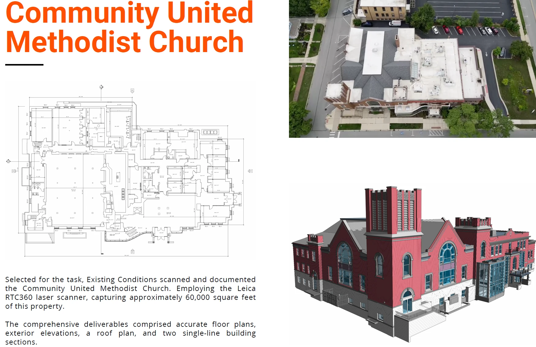
Salvation Army
Existing Conditions conducted a thorough scanning and documentation process, encompassing approximately 60,000 square feet across two vacant industrial buildings on the property.
The experts at Existing Conditions meticulously scanned both the interiors and exteriors of these structures and provided the client with accurate sets of floor plans, reflected ceiling plans, exterior elevations, and roof plans.
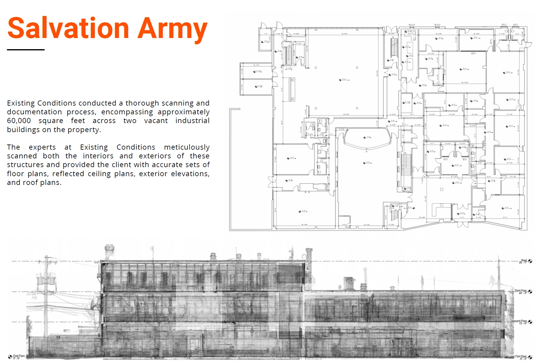
University of Chicago Divinity School
Working at the Divinity School of the University of Chicago proved to be a captivating endeavor due to the academic building's gothic architecture combined with its status as an early 20th-century structure.
The Existing Conditions team scanned this property with precision, minimizing disruptions to the daily activities of students and occupants. This level of consideration is always a priority for us, and it was particularly crucial in this case, considering the building's role as an active seminary.
The client was provided with detailed floor plans, interior elevations, and exterior elevations of the building. With these deliverables, the client could initiate the rehabilitation process with a precise and reliable starting point.
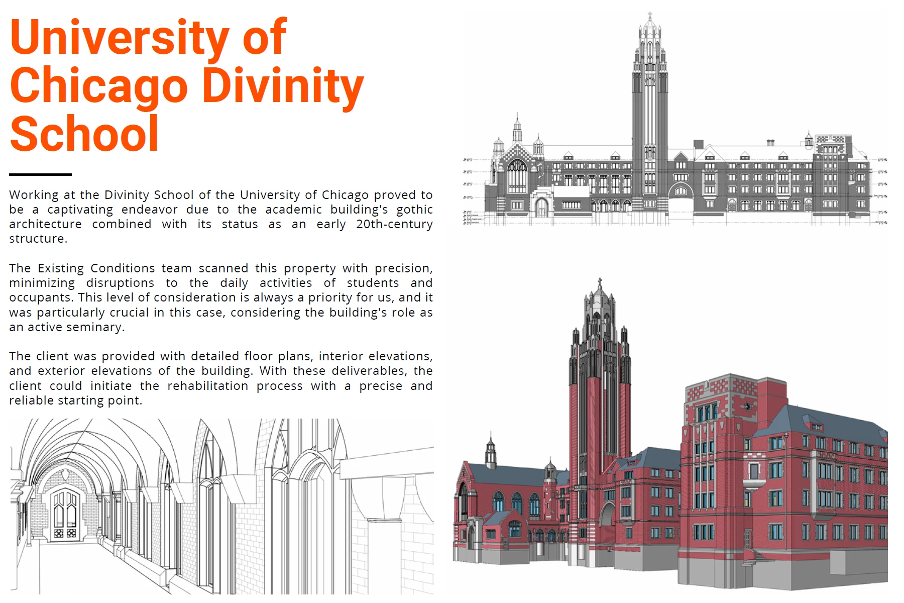
Willis Tower
In the initial stages of a renovation project exceeding $500 million, the Gensler Chicago office selected Existing Conditions to scan and document the Willis Tower, the third largest building in the United States. To ensure seamless daily operations of the tower, the Existing Conditions team conducted the laser scanning process at night.
The deliverables included detailed floor plans, reflected ceiling plans, and exterior elevations. Furthermore, MEP/FP documentation was provided in a separate model to avoid overburdening the architectural model.
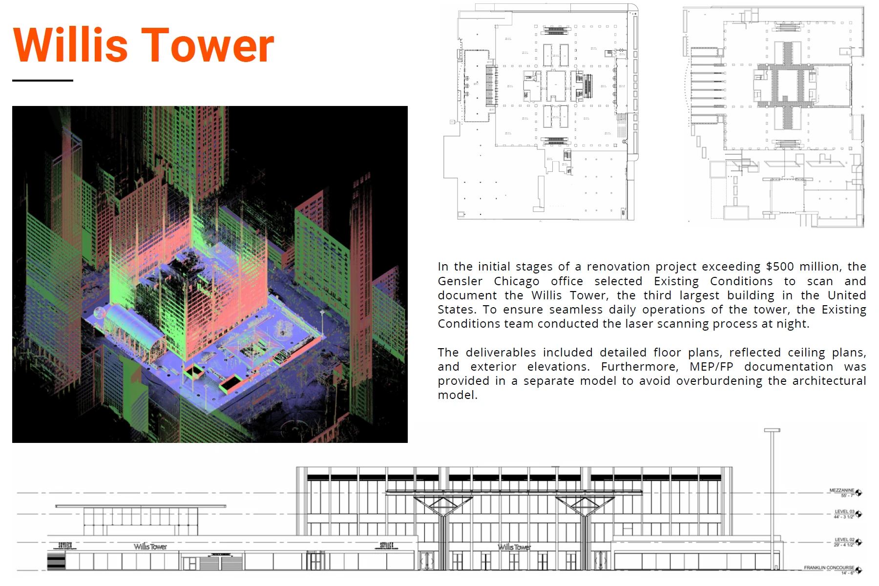
Food Warehouse
With over two decades of experience and expertise, Existing Conditions was chosen to scan and document this industrial warehouse, given the critical importance of accuracy and attention to detail in the industrial sector.
In addition to scanning the warehouse and providing accurate floor plans of the space, Existing Conditons scanned specific portions of the processing plant to meet the clients needs.
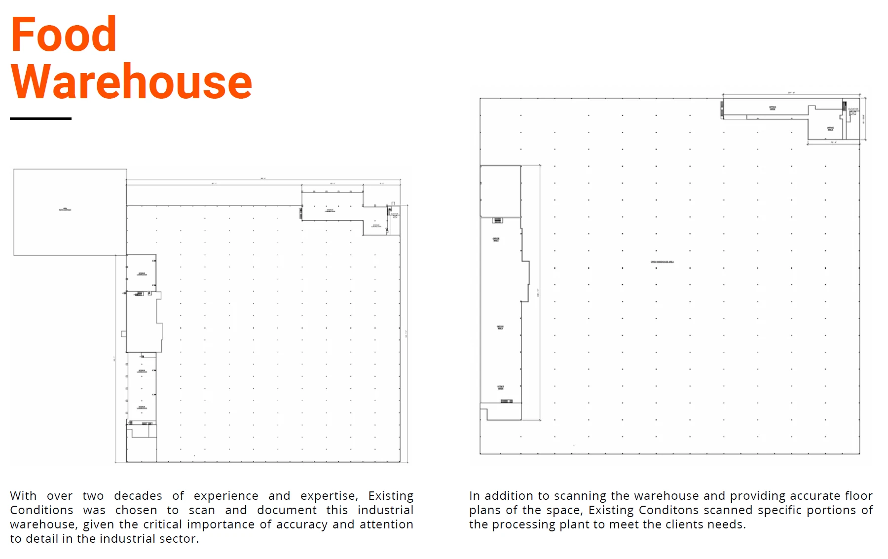
Existing Conditions provides professionals with situational awareness and empowers them with the confidence to make smart decisions based on accurate data. Building industry professionals can use our plans for renovations, continuous facility management, and accessibility studies of all buildings documented.
One of the reasons our clients appreciate working with us is that we are easy to do business with. Our clients know that they can reach out to us at any time and that we will be a reliable partner for them. We consider ourselves to be an extension of their team, bringing unmatched experience and expertise so they can focus on what they do best.
Download e-Book of Our Chicago Projects
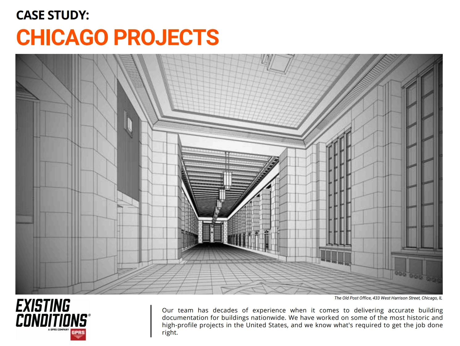
Existing Conditions 3D Laser Scanning Services
Over the past 27 years, we have measured, documented, and modeled over 10,000 buildings spanning over 700 million square feet across the United States, establishing ourselves as an industry leader in 3D laser scanning. Architects, builders, engineers, developers, facility managers, trust us to deliver digital representations of the as-built environment with unparalleled accuracy and efficiency. Our dedicated Project Managers provide fast and accurate 3D laser scanning services and drone imagery services, and expert CAD and BIM technicians create custom, detailed deliverables. Our greatest reward remains delivering superior-quality scan-to-BIM work and knowing we played a vital role in our clients’ unique and historic projects.
Civic & Government Building 3D Laser Scanning Services
Our team possesses decades of specialized experience in delivering 3D laser scanning services tailored to the unique needs of civic and government structures. We've had the privilege to lend our expertise to some of the most historic and high-profile government projects in the United States, and we understand the distinctive requirements associated with these monumental buildings.

Preserving Heritage: Civic and government buildings often hold profound historical significance. We recognize the importance of preserving their heritage while providing precise documentation. Our approach combines cutting-edge technology with a deep respect for the architectural legacy of these structures.
Regulatory Compliance: Government projects demand strict adherence to regulatory standards. Our team is well-versed in navigating the complex landscape of compliance, ensuring that all documentation aligns with the necessary guidelines and regulations.
National Landmarks: Many government buildings are national landmarks, embodying the essence of our nation's history. We approach each project with the reverence it deserves, capturing every detail to immortalize these landmarks in digital form.
Efficiency and Accuracy: Efficiency is paramount in government projects. Our decades of experience have honed our ability to deliver accurate documentation promptly, minimizing disruption and ensuring projects progress seamlessly.
Experienced Team: Our seasoned professionals understand the intricacies of working within the civic and government sector. We bring unmatched knowledge and insights to every project, ensuring that the job is executed flawlessly.
When it comes to accurate building documentation for civic and government buildings, you can rely on our team's expertise and dedication to get the job done right. We take pride in contributing to the preservation and modernization of these vital structures.
3D Laser Scanning Civic & Government Buildings Experience and Expertise
Our team has decades of experience when it comes to delivering accurate building documentation for civic buildings. We've had the privilege to work on some of the most historic and high-profile civic projects in the United States, and we know what's required to get the job done right. Below is a selection of relevant projects we have measured and modeled in recent years.
1. United States Senate Chamber, Washington, D.C.
2. The Pentagon, Washington, D.C.
3. The State Department, Washington, D.C.
4. Massachusetts State House, Boston, MA
5. Massachusetts Senate Chamber and House of Representatives, Boston, MA
6. The Royal Italian Embassy, Washington, D.C.
7. The Embassy of Belarus, Washington, D.C.
8. United States Embassy, Monrovia, Liberia
9. Boston City Hall, Boston, Massachusetts
10. Hartford City Hall, Hartford, CT
Existing Conditions 2D CAD Drawing & 3D BIM Model Deliverables for Civic & Government Buildings
Architectural Layouts: Floor plans, elevations, sections, and RCPs showing the current configuration of walls, doors, windows, and more to document a building’s layout.
Structural Details: Up to date information about load-bearing walls, beams, columns, and foundation systems to understand a building's structural integrity and constraints.
Building Dimensions: Accurate measurements of all spaces, including heights, widths, and depths to avoid discrepancies during design.
MEP Systems: Location and layout of HVAC systems, electrical wiring, plumbing, and fire protection systems for redesign or upgrades.
Material Specifications: Details on existing materials used in walls, floors, roofs, and finishes for construction or renovation planning.
Condition Assessments: Documentation of the building’s current condition, identifying issues such as cracks, leaks, or wear that may require attention.
Existing Conditions 3D Laser Scanning Services for Civic & Government Buildings
Over the past 27 years, we have measured, documented, and modeled over 10,000 buildings spanning over 700 million square feet across the United States, establishing ourselves as an industry leader in 3D laser scanning. Architects, builders, engineers, developers, and facility managers, trust us to deliver digital representations of the as-built environment with unparalleled accuracy and efficiency. Our dedicated Project Managers provide fast and accurate 3D laser scanning services and drone imagery services, and expert CAD and BIM technicians create custom, detailed deliverables. Our greatest reward remains delivering superior-quality scan-to-BIM work and knowing we played a vital role in our clients’ unique and historic projects.
Commercial Real Estate Professionals Benefit From 3D Laser Scanning Services
In the realm of commercial real estate (CRE), professionals and industry leaders such as JLL have harnessed the power of Building Information Modeling (BIM) and 3D laser scanning to revolutionize the way decisions are made, and information is utilized. This strategic integration of technology brings about long-lasting benefits not only for the industry but, crucially, for clients as well.
Here's a glimpse into how these innovative practices are transforming the CRE landscape:
- Tenant Attraction and Leasing Efficiency:
- 3D Walk-Throughs: By sharing immersive 3D walk-throughs of properties with clients, regardless of their location, the need for scheduling in-person visits is eliminated. This breakthrough enables CRE professionals to attract tenants more swiftly and showcase properties to a broader audience simultaneously.
- Compelling Design Visualization:
- 3D Visuals for Proposals: CRE experts leverage 3D visualization to present proposed designs with stunning clarity. This not only aids in conveying ideas effectively but also engages clients, communities, and stakeholders by providing them with a tangible visual representation of the envisioned project.
- Informed Change Management:
- Impact Assessment: BIM and laser scanning data empower CRE professionals to assess the potential impact of proposed changes before committing to costly alterations. This proactive approach ensures informed decision-making by offering real-time insights into how modifications will influence the property's appearance and what each option entails in terms of cost.
Incorporating BIM and laser scanning into the CRE toolkit enhances transparency, fosters trust, and streamlines decision-making processes. These cutting-edge technologies empower professionals to optimize their strategies, minimize risks, and deliver superior outcomes to clients. As the industry continues to embrace these advancements, the future of commercial real estate looks promising, with a greater emphasis on data-driven precision and efficiency.
.png)
Existing Conditions 3D Laser Scanning and Drone Imagery for Commercial Real Estate
Leverage our 3D laser scanning, modeling, and drone survey experience, equipment, and expertise for your commercial real estate or development project. The point clouds, as-built drawings, 3D BIM models, and drone video and imagery we deliver removes human error from the documentation process and delivers accurate data to better assess the condition of the building, plan renovations, identify potential issues, visualize future changes, and make informed investment decisions.
What are the Benefits to 3D Laser Scanning Commercial Real Estate?
Critical Building Information
As a commercial real estate developer, you need reliable existing conditions documentation to support a wide range of business applications, including building valuation, lease administration, property management, adaptive reuse, space planning, and tenant fit-outs. We understand that your time is valuable, which is why we work efficiently to deliver the as-built data you need in a timely manner. We work as an extension of your team, providing you with accurate floor plans, BIM models, virtual tours, and more to optimize return on investment on your projects and portfolios.
Accurate and Efficient Data Capture
Unreliable or outdated as-builts can interfere with your commercial real estate project, leading to inaccurate cost estimates, rework, and delays. We have extensive experience working with real estate investors, developers, and owners, who trust us to deliver detailed insights into a property’s condition and potential with unparalleled accuracy and efficiency.
Reliable Documentation
Our 3D laser scanning services, 2D CAD drawings, 3D BIM models, and drone video & imagery provide comprehensive as-built data of existing site conditions to assess and plan for your real estate development project.
Streamline Workflows
Accurate as-builts help to coordinate with architects, contractors, and other stakeholders for smoother project execution. By trusting the experts at Existing Conditions, you will receive accurate property documentation in a digital asset.
Improved Collaboration
Utilize accurate as-built data and models to collaborate more effectively with your team, efficiently manage the property, begin renovation design planning, incorporate sustainability, specify materials, obtain permits, and estimate lease and construction costs accurately.
Existing Conditions 2D CAD Drawing & 3D BIM Model Deliverables
Architectural Layouts: Floor plans, elevations, sections, and RCPs showing the current configuration of walls, doors, windows, and more to document a building’s layout.
Structural Details: Up to date information about load-bearing walls, beams, columns, and foundation systems to understand a building's structural integrity and constraints.
Building Dimensions: Accurate measurements of all spaces, including heights, widths, and depths to avoid discrepancies during design.
MEP Systems: Location and layout of HVAC systems, electrical wiring, plumbing, and fire protection systems for redesign or upgrades.
Material Specifications: Details on existing materials used in walls, floors, roofs, and finishes for construction or renovation planning.
Condition Assessments: Documentation of the building’s current condition, identifying issues such as cracks, leaks, or wear that may require attention.
Existing Conditions 3D Laser Scanning Services
Over the past 27 years, we have measured, documented, and modeled over 10,000 buildings spanning over 700 million square feet across the United States, establishing ourselves as an industry leader in 3D laser scanning. Architects, builders, engineers, developers, facility managers, trust us to deliver digital representations of the as-built environment with unparalleled accuracy and efficiency. Our dedicated Project Managers provide fast and accurate 3D laser scanning services and drone imagery services, and expert CAD and BIM technicians create custom, detailed deliverables. Our greatest reward remains delivering superior-quality scan-to-BIM work and knowing we played a vital role in our clients’ unique and historic projects.
Common Delays in 3D Laser Scanning Services
Other common causes for delays 3D laser scanning on-site include:
- Obstructions - If your scope includes obscured elements such as electrical outlets or switches behind furniture or other encumbrances, it is necessary to move or remove such obstacles prior to arrival
- Access – not having the latest set of keys or door code necessary to enter all of the property
- Last-minute notice – in some buildings, tenants must be given advance notice of work
- Weather – exterior scanning can be delayed or canceled if weather is severe
- Government order – some governments mandate prohibited periods of construction activity
- Construction sites – any disruption such as vibration can impact the scanning procedure
- Furniture – blocking electrical outlets or any hidden components
- Ceiling tiles – ACT and suspended ceiling systems must be selectively removed before our crews arrive on-site–we cannot scan through ceiling tiles
Unfortunately, today's most advanced 3D laser scanning technology does not have the ability to capture spatial data directly behind solid objects. If you are unable to remove these types of obstacles, please let us know so we can factor that into our delivery estimates.
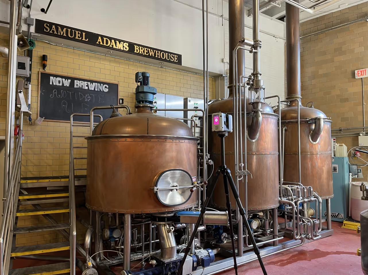
Existing Conditions 3D Laser Scanning Services
Over the past 27 years, we have measured, documented, and modeled over 10,000 buildings spanning over 700 million square feet across the United States, establishing ourselves as an industry leader in 3D laser scanning. Architects, builders, engineers, developers, facility managers, trust us to deliver digital representations of the as-built environment with unparalleled accuracy and efficiency. Our dedicated Project Managers provide fast and accurate 3D laser scanning services and drone imagery services, and expert CAD and BIM technicians create custom, detailed deliverables. Our greatest reward remains delivering superior-quality scan-to-BIM work and knowing we played a vital role in our clients’ unique and historic projects.
Compatible Software for Point Cloud Data
Point cloud data is a versatile resource that can be effectively integrated into various software applications to serve different purposes. Here are some notable software options that are compatible with point cloud data:
AutoCAD
AutoCAD is a powerful software application developed by Autodesk for computer-aided design and drafting. It offers a wide range of functionalities, including the creation of building blueprints and detailed drawings. AutoCAD's compatibility with point cloud data makes it an invaluable tool for architects, engineers, and designers who need to incorporate precise measurements and real-world data into their designs.
Revit
Revit, also developed by Autodesk, is a comprehensive Building Information Modeling (BIM) software. With Revit, users can design buildings, structures, and building components in 3D, while also annotating the model with 2D drafting elements. Point cloud data integration enhances Revit's capabilities, allowing for more accurate and efficient modeling, visualization, and collaboration in the construction industry.
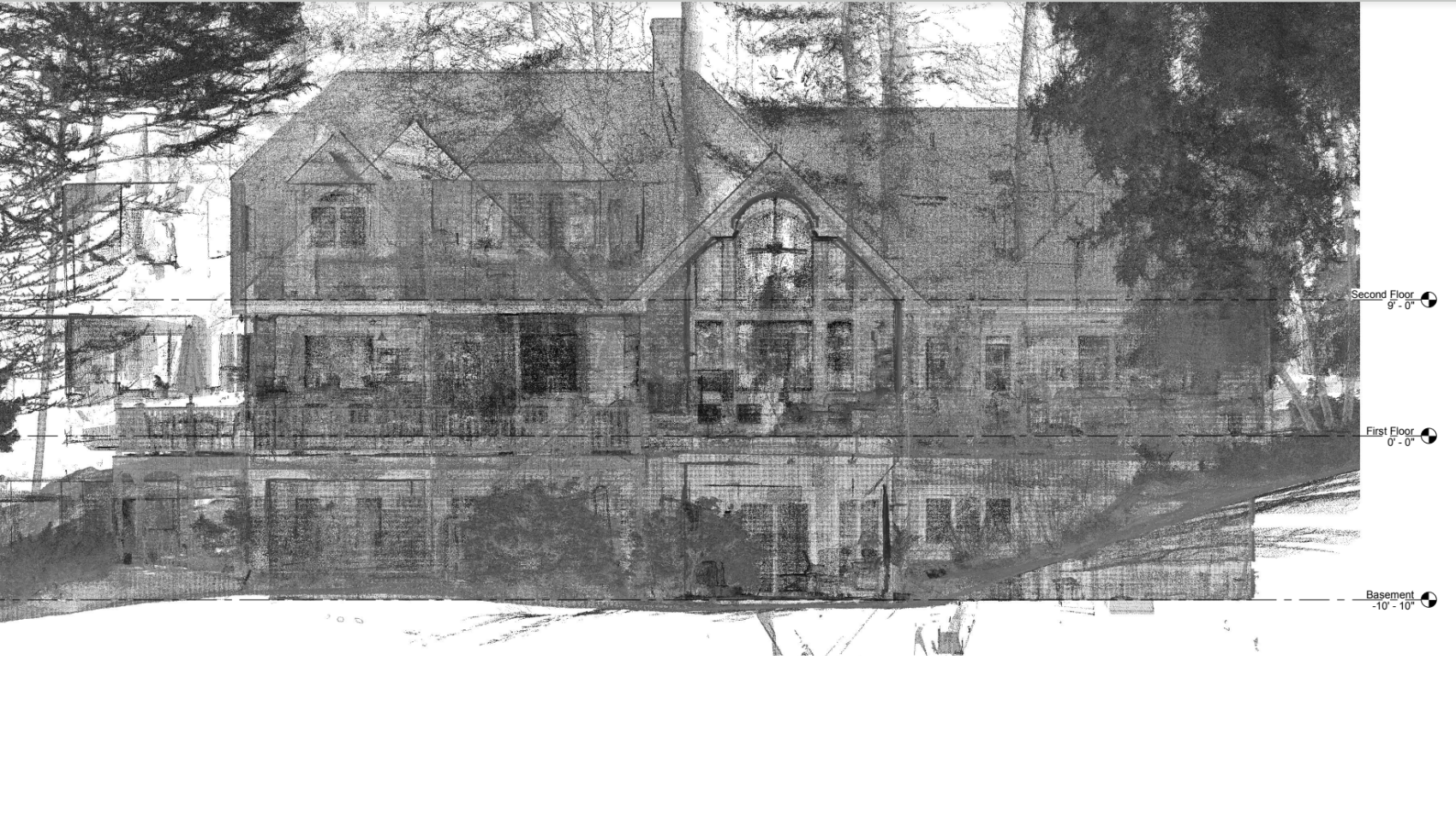
TruView/Jetstream
TruView, formerly known as Jetstream, is a software tool offered by Leica that specializes in working with 3D laser scanning data. It stands out for its ability to streamline the process of handling point cloud data and compressing it with minimal data loss. TruView/Jetstream facilitates efficient data management and analysis, making it a valuable asset for professionals dealing with large volumes of point cloud data.
Scene LT
Scene LT is a user-friendly, free point cloud data viewing software provided by FARO. Specifically designed for viewing FARO laser scanner scan data, it simplifies the sharing and viewing of point cloud data among project collaborators. Scene LT offers accessibility and ease of use, making it a practical choice for those working with FARO scanners.
Other Compatible Software
In addition to the mentioned software, point cloud data can be used effectively with other applications such as Vectorworks, Tekla, and ArchiCAD. These software options cater to specific industries and purposes, offering flexibility for professionals across various fields.
Explore Hardware Requirements
If you are interested in viewing point cloud data and want to understand the hardware requirements for a smooth experience, we provide detailed information on the topic.
Existing Conditions 3D Laser Scanning Services
Over the past 27 years, we have measured, documented, and modeled over 10,000 buildings spanning over 700 million square feet across the United States, establishing ourselves as an industry leader in 3D laser scanning. Architects, builders, engineers, developers, and facility managers, trust us to deliver digital representations of the as-built environment with unparalleled accuracy and efficiency. Our dedicated Project Managers provide fast and accurate 3D laser scanning services and drone imagery services, and expert CAD and BIM technicians create custom, detailed deliverables. Our greatest reward remains delivering superior-quality scan-to-BIM work and knowing we played a vital role in our clients’ unique and historic projects.
Contact us today for a free project estimate.
Critical Facility 3D Laser Scanning Services
With decades of experience, the Existing Conditions team specializes in delivering precise building documentation tailored to critical facilities, such as prisons, hospitals, mental institutions or any facility that services public health and/or safety. We've had the privilege of contributing our expertise to some of the most vital and sensitive projects in this sector, and we understand the unique demands and requirements involved.
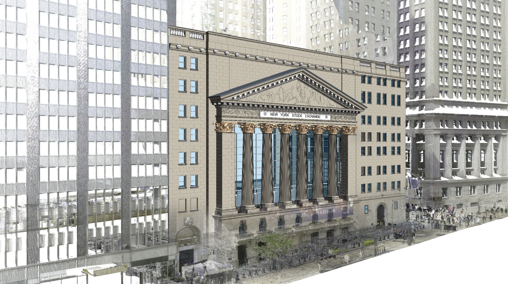
Here's how our experience benefits clients in the critical facilities sector:
- Stringent Standards: Critical facilities often operate under strict regulations and standards, such as those in healthcare, data centers, or research institutions. Our as-built documentation ensures compliance with these standards, providing a solid foundation for operations and regulatory inspections.
- Mission-Critical Accuracy: In environments where even minor errors can have significant consequences, our team's commitment to accuracy is paramount. We provide detailed and precise documentation that supports critical functions and decision-making.
- Security and Confidentiality: We recognize the importance of security and confidentiality in critical facilities. Our team adheres to strict protocols to protect sensitive information while delivering the documentation necessary for efficient operations.
- Resilience and Redundancy: Critical facilities often require robust infrastructure with built-in redundancy and resilience. Our documentation reflects these features, ensuring that critical systems are well-documented for maintenance and troubleshooting.
- Emergency Preparedness: Our documentation supports emergency preparedness and response efforts. It provides essential information for personnel to respond effectively to crises and minimize downtime.
- Efficient Maintenance: We design our documentation to facilitate efficient maintenance and servicing of critical systems. This contributes to reduced downtime and improved reliability.
- Collaboration and Communication: Effective collaboration and communication are essential in critical facilities. Our documentation aids in conveying complex information to diverse teams, fostering better coordination and decision-making.
- Customized Solutions: Every critical facility is unique, and our team tailors the documentation to specific needs and objectives. Whether it's a healthcare facility, a secure government installation, or a data center, we provide solutions that align with the facility's purpose.
- Disaster Recovery: Our documentation includes vital data that supports disaster recovery planning. It ensures that critical systems can be restored swiftly in the event of unexpected disruptions.
- Sustainability: We integrate sustainable practices into our documentation, aligning with the growing emphasis on environmental responsibility in critical facility operations.
Our commitment to accuracy, security, and customized solutions makes us a trusted partner for critical facilities. We understand the importance of these facilities in maintaining essential services, and we take pride in delivering documentation that upholds their critical missions.
3D Laser Scanning Critical Facilities
Existing Conditions 3D laser scanning services provide accurate, high-quality spatial data that can be used to make decisions about every facet of your facility. The point clouds, as-built drawings, 3D BIM models, and drone imagery we deliver removes human error from the documentation process and provides a reliable reference for long-term facility management, renovations, and upgrades. 3D laser scanning is a strategic investment that captures precise facility as-builts and can lead to substantial cost savings over time.
Existing Conditions 3D Laser Scanning Services
Over the past 27 years, we have measured, documented, and modeled over 10,000 buildings spanning over 700 million square feet across the United States, establishing ourselves as an industry leader in 3D laser scanning. Architects, builders, engineers, developers, and facility managers, trust us to deliver digital representations of the as-built environment with unparalleled accuracy and efficiency. Our dedicated Project Managers provide fast and accurate 3D laser scanning services and drone imagery services, and expert CAD and BIM technicians create custom, detailed deliverables. Our greatest reward remains delivering superior-quality scan-to-BIM work and knowing we played a vital role in our clients’ unique and historic projects.
Contact us today for a free project estimate.
Data Hosting and Security at Existing Conditions
Data security is paramount to us at Existing Conditions. That is why our servers adhere to the strictest security and privacy standards. We are proud to be responsible stewards of your valuable data and are happy to host the files for you now, and in the future. Our data storage providers undergo several independent third-party audits on a regular basis, including ISO/IEC 27001, ISO/IEC 27017, ISO/IEC 27018, SOC 2/3, and FedRAMP.
We typically keep project files readily available for one year, after which they are archived. Archived files are still accessible, but the original link we sent upon project delivery will no longer be active. If you need access to files from an archived project, just reach out to us and we can send you a new link.
Some of our clients inquire about web-based platforms for viewing point clouds and scan data. These systems allow users to easily view scan data without needing to download large data sets or install new software. If you would prefer to use a web-based scan data viewing platform, please let us know and we will apprise you on the additional costs required.
Existing Conditions 3D Laser Scanning Services
Over the past 27 years, we have measured, documented, and modeled over 10,000 buildings spanning over 700 million square feet across the United States, establishing ourselves as an industry leader in 3D laser scanning. Architects, builders, engineers, developers, facility managers, trust us to deliver digital representations of the as-built environment with unparalleled accuracy and efficiency. Our dedicated Project Managers provide fast and accurate 3D laser scanning services and drone imagery services, and expert CAD and BIM technicians create custom, detailed deliverables. Our greatest reward remains delivering superior-quality scan-to-BIM work and knowing we played a vital role in our clients’ unique and historic projects.
Deformation Maps From 3D Laser Scanning
Understanding Deformation Maps
Deformation maps are a valuable tool used in construction and engineering to visualize the topography of a built surface. They provide a clear and detailed representation of the elevation of the floor or surface at various points. These maps serve several crucial purposes:
Identifying Uneven Floors
Deformation maps are particularly useful for identifying and addressing uneven floors. They offer a visual depiction of elevation variations across a floor, helping professionals pinpoint areas where the surface deviates from the desired level.
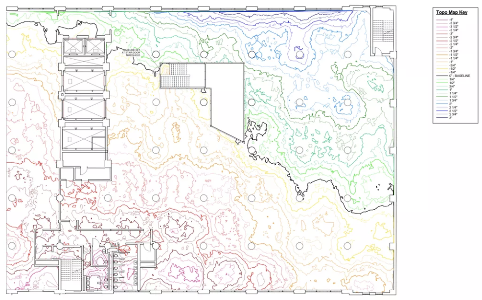
Evaluating Exterior Wall Deflections
In addition to uneven floors, deformation maps can also be applied to exterior walls. They help reveal any deflections or deviations in the wall's alignment. This information is crucial for assessing structural integrity and identifying potential issues that may require correction.
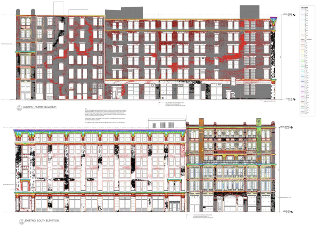
High and Low Points
Much like topography maps used for land, deformation maps display high and low points throughout a building's floors or surfaces. These maps provide a comprehensive view of elevation changes, allowing professionals to identify areas of concern or interest.
Quantifying Concrete Requirements
Deformation maps play a vital role in construction planning. They assist in estimating the amount of concrete needed to level or correct uneven surfaces. By analyzing the elevation data provided by deformation maps, project teams can make informed decisions about materials and resources.
Understanding Structural Impacts
Deformation maps can also reveal the impact of weight and load on a structural system. By visualizing elevation changes caused by heavy loads, engineers can assess the stress on a building's components and make necessary adjustments to ensure structural stability.
In summary, deformation maps are a powerful tool for assessing the topography of built surfaces, whether it's uneven floors, deflected walls, or structural considerations. These as-built drawings offer valuable insights into elevation variations, helping professionals make informed decisions, plan construction projects, and ensure the integrity and safety of buildings.
Existing Conditions 3D Laser Scanning Services
Over the past 27 years, we have measured, documented, and modeled over 10,000 buildings spanning over 700 million square feet across the United States, establishing ourselves as an industry leader in 3D laser scanning. Architects, builders, engineers, developers, and facility managers, trust us to deliver digital representations of the as-built environment with unparalleled accuracy and efficiency. Our dedicated Project Managers provide fast and accurate 3D laser scanning services and drone imagery services, and expert CAD and BIM technicians create custom, detailed deliverables. Our greatest reward remains delivering superior-quality scan-to-BIM work and knowing we played a vital role in our clients’ unique and historic projects.
Document Scanning & Digital Storage Services
In a hybrid world of paper and electronic information, professionals in the building industry can benefit greatly from a unified view of their information. Without an organized system for managing the information about your buildings, you and your team may be forced to spend precious time searching for what you need. And when you do find the information you need, if it’s in a physical paper format you still can’t easily access or share information with others, especially your remote workforce.
Through a combination of Existing Conditions' document scanning expertise, infrastructure, and a modern, secure cloud storage repository, we can help you find what you need – quickly, affordably, and seamlessly. We'll help you prioritize and achieve your goals through a structured digitization process.
Your document scanning will be done by Existing Conditions – the provider that you already trust with your building documentation. We know the language of buildings, and can help you manage the entire information lifecycle for both your physical and digital information. You’ll be able to centrally access information about your buildings, freeing up valuable workspace and simplifying how you manage your data.
How Document Scanning & Digital Storage Works
You can count on Existing Conditions' experts. They have the experience, workflows, and infrastructure to scan, index, and ensure quality control to meet your requirements. See below for a closer look at how our structured process can produce better visibility into your information:
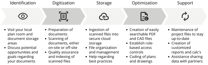
Features and Benefits of Digitization
With Existing Conditions' Document Scanning & Digital Storage Services you’ll be able to:
Free Up Space
Leverage Existing Conditions' experience, equipment, and expertise to convert your physical documents into digital files. Get organized and free up space in your workplace that was previously used for document storage.
Securely Protect Your Information
Data security is paramount to us at Existing Conditions. That is why our servers adhere to the strictest security and privacy standards. We are proud to be responsible stewards of your valuable data, and are happy to host the files for you now, and in the future. Role-based permissions enable authorized users to access only the information that they need.
Centralize Access
We can ingest documents from other locations, such as other cloud storage platforms, enterprise content management systems, and file sharing links from third-parties. We centrally store scanned and digitally-native documents for enhanced visibility and access.
Quickly Search
By establishing a logical organization system for your digitized files, your team will be empowered to quickly find the information that they are looking for. Whether it is a PDF, CAD file, or BIM project, structured organization pays huge dividends in the amount of time it saves your team.
Next Steps
If you'd like to learn more, visit our portfolio, or contact us to connect with a member of our team.
Downloading 3D Laser Scanning Project Files
Download One File At A Time
Depending on the scale of the project, point cloud data can range in size from one gigabyte (GB) to multiple terabytes (TB, approx. 1000 GB) in size. Do not try to download multiple files at one time or download a folder filled with files. This will start a zipping process on Google Drive that will likely cause the download to fail.
The best method is to download one file at a time until all the files you need are downloading. Multiple downloads of individual files may be run simultaneously.
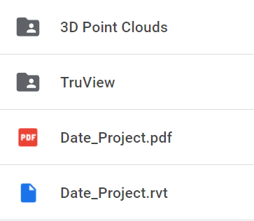
Which data do I need?
To use point clouds in Revit or AutoCAD, you will need to download the files found in the 3D Point Clouds folder. These will be RCS files that can be used by Autodesk products. Click here for tips on Working with point cloud data.
For viewing the first-person 360 panoramic images, you will need to download the files located in the TruView (aka Jetstream) or Scene Scan Data folders. You will also need to download either the TruView/Jetstream (for LGS files) or Scene LT (for FWS files, usually zipped) software for opening these files. These programs are available for free.
Where should I save the downloads?
The local machine is the best place to store point cloud data, however one must ensure there is enough room to handle the file sizes before downloading. All point cloud data is very large and usually runs from 2GB up to 70GB, and sometimes more.
Point cloud data can be stored on your servers, but the RCS files for use in Revit or AutoCAD should be located on the local machine in order to allow the Autodesk software to more quickly refresh views.
Can my computer handle these files?
Please note that neither viewing software can run on a Mac. In order to run Scene LT you will need to have a dedicated video card (which is not typical for most laptops). The point cloud files should be saved on a solid state hard drive (SSD) on individual machines.
Alternatively, Existing Conditions' Virtual Site Visits platform is an easy and low cost way to access spatial data of your building or project, regardless of your operating system or hardware. You can use the platform on any desktop, tablet, or mobile device – all you need is an internet connection.
Contact us today for assistance downloading 3D laser scanning project files.
Existing Conditions 3D Laser Scanning Services
Over the past 27 years, we have measured, documented, and modeled over 10,000 buildings spanning over 700 million square feet across the United States, establishing ourselves as an industry leader in 3D laser scanning. Architects, builders, engineers, developers, and facility managers, trust us to deliver digital representations of the as-built environment with unparalleled accuracy and efficiency. Our dedicated Project Managers provide fast and accurate 3D laser scanning services and drone imagery services, and expert CAD and BIM technicians create custom, detailed deliverables. Our greatest reward remains delivering superior-quality scan-to-BIM work and knowing we played a vital role in our clients’ unique and historic projects.
Engineers Benefit From 3D Laser Scanning Services
Engineers worldwide, including esteemed firms such as VHB, Jensen Hughes, and Stantec, have long relied on Existing Conditions for engineering-grade 3D laser scanning and Building Information Modeling (BIM) expertise. Our comprehensive data solutions offer engineers a wide range of invaluable benefits:
- Efficiency: Streamlined workflows and access to accurate, up-to-date data enhance project efficiency, reducing the time required for assessments, designs, and modifications.
- Reduced Costs: By minimizing the need for frequent site visits and rework, our 3D laser scanning and BIM services contribute to cost savings throughout the project lifecycle.
- Speed: Engineers can access precise, panoramic views of large sites swiftly, enabling rapid decision-making and project progress.
- Precision and Accuracy: The data we provide is highly accurate, ensuring that engineering calculations and designs are based on reliable information, minimizing errors.
- Fewer Site Visits: With our detailed digital representations of physical environments, engineers can make informed decisions remotely, reducing the necessity for on-site visits and associated expenses.
- Increased Safety: Identifying vulnerabilities and assessing safety risks can be achieved without physical presence on-site, contributing to enhanced safety measures.
When engineers choose 3D laser scanning and BIM solutions from Existing Conditions, they gain access to a powerful toolset that optimizes their projects for efficiency, cost-effectiveness, and safety. Our commitment to accuracy and quality ensures that engineers can rely on our data to drive successful engineering outcomes.
Existing Conditions 3D Laser Scanning Services
Over the past 27 years, we have measured, documented, and modeled over 10,000 buildings spanning over 700 million square feet across the United States, establishing ourselves as an industry leader in 3D laser scanning. Architects, builders, engineers, developers, and facility managers, trust us to deliver digital representations of the as-built environment with unparalleled accuracy and efficiency. Our dedicated Project Managers provide fast and accurate 3D laser scanning services and drone imagery services, and expert CAD and BIM technicians create custom, detailed deliverables. Our greatest reward remains delivering superior-quality scan-to-BIM work and knowing we played a vital role in our clients’ unique and historic projects.
Estimating 3D Laser Scanning Project Costs
Explaining Existing Conditions' Customized Approach to Estimating Project Costs
Estimating project costs is a critical aspect of any construction project, and at Existing Conditions, we take a customized approach to ensure affordability and precision. Our existing conditions surveys are designed to be the most cost-effective solution for your unique needs.
Key points to consider:
- Tailored Quotes: We understand that every project is distinct, with its own set of requirements and challenges. Therefore, we provide custom quotes based on the specific building, project scope, and individual needs. This tailored approach ensures that you receive accurate pricing aligned with your project's unique demands.
- Proven Track Record: With over 20 years of experience in the field, we have consistently saved our clients both time and money. Our commitment to delivering superior quality work, on time and within budget, sets us apart.
- Expertise and Equipment: Our dedicated team brings a wealth of expertise to the table, backed by high-quality equipment and technology. We leverage our experience and resources to provide you with the best possible project outcomes.
- Request a Quote: To discover how our services can meet your project's needs while staying within your budget, please click here to initiate the quotation process.
At Existing Conditions, we prioritize delivering exceptional building documentation services that align with your project's financial parameters and goals. Our commitment to affordability and quality ensures that you receive the most cost-effective existing conditions surveys available.
Existing Conditions 3D Laser Scanning Services
Over the past 27 years, we have measured, documented, and modeled over 10,000 buildings spanning over 700 million square feet across the United States, establishing ourselves as an industry leader in 3D laser scanning. Architects, builders, engineers, developers, facility managers, trust us to deliver digital representations of the as-built environment with unparalleled accuracy and efficiency. Our dedicated Project Managers provide fast and accurate 3D laser scanning services and drone imagery services, and expert CAD and BIM technicians create custom, detailed deliverables. Our greatest reward remains delivering superior-quality scan-to-BIM work and knowing we played a vital role in our clients’ unique and historic projects.
Existing Conditions Visualizes Buildings in Palm Beach
Existing Conditions Visualizes Buildings in Palm Beach
With our extensive experience in delivering precise building documentation in Palm Beach, we bring a wealth of knowledge and expertise to projects in this unique and prestigious location. Over the decades, we've had the privilege of contributing to some of Palm Beach's most historic and high-profile buildings, understanding the specific requirements and challenges that come with these exceptional properties.
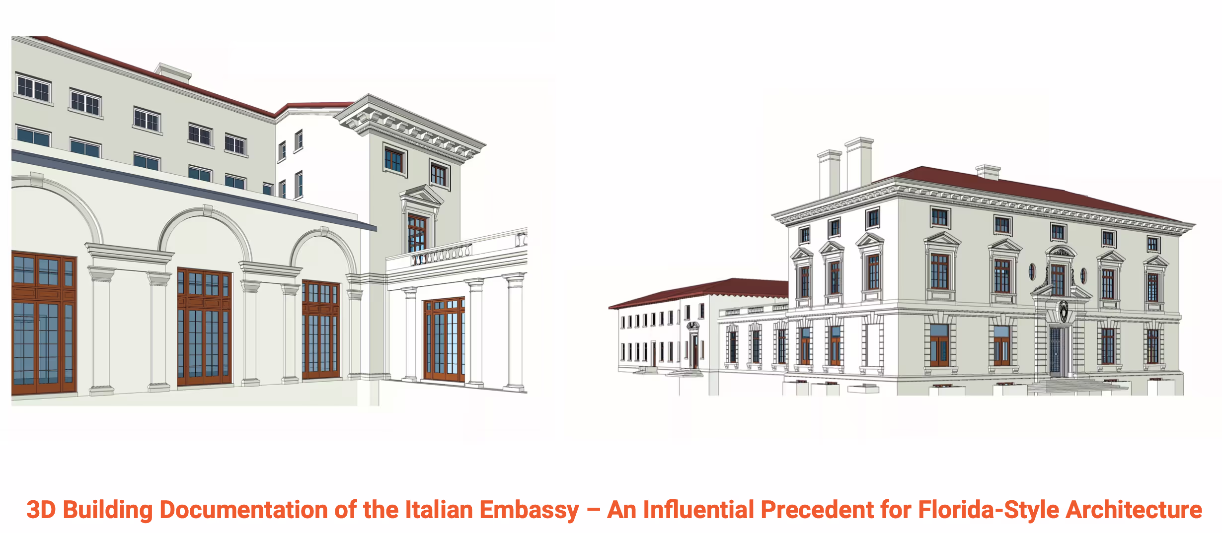
Here's how our experience benefits clients in Palm Beach:
- Historic Preservation: Palm Beach is renowned for its rich architectural heritage. Our team is well-versed in the principles of historic preservation, ensuring that accurate documentation preserves the unique character and historical significance of these buildings.
- Regulatory Compliance: Many properties in Palm Beach are subject to strict zoning and preservation regulations. We navigate these regulatory landscapes effectively, ensuring that our documentation aligns with local requirements.
- Architectural Excellence: Palm Beach is synonymous with architectural excellence. We appreciate the importance of capturing every intricate detail of these exceptional buildings, whether they feature Mediterranean Revival, Colonial Revival, or other architectural styles.
- Luxury Properties: Palm Beach is home to luxury estates and properties. Our documentation reflects the high standards and attention to detail that characterize these exclusive residences.
- Gardens and Landscapes: Beyond the buildings, Palm Beach properties often boast lush gardens and landscapes. Our documentation extends to these outdoor spaces, preserving their beauty and design for future generations.
- Coastal Considerations: Given Palm Beach's coastal location, properties may face unique challenges related to salt exposure and hurricane preparedness. We incorporate these considerations into our documentation to support resilience and maintenance.
- Community Engagement: Palm Beach communities value community engagement and collaboration. Our documentation aids in communication with local stakeholders, facilitating a smooth project process.
- Enhancing Property Value: Accurate documentation enhances property value by providing a comprehensive record of the building's condition, design, and historical context. This can be invaluable for property owners and prospective buyers.
- Customized Solutions: Every property in Palm Beach has its own character and requirements. Our team tailors our documentation services to meet the specific needs and objectives of each project, whether it's a historic mansion, a boutique hotel, or a cultural institution.
- Preserving Palm Beach's Legacy: We take pride in our role in preserving Palm Beach's architectural legacy. Our documentation ensures that the stories and significance of these remarkable buildings continue to be celebrated and protected.
Our commitment to precision, respect for architectural heritage, and dedication to meeting the unique demands of Palm Beach properties make us a trusted partner for building documentation in this prestigious community. We recognize the privilege of working in such a distinctive location and are dedicated to upholding the standards of excellence that define Palm Beach.
If you'd like to learn more, visit our portfolio, or contact us to connect with a member of our team.
Existing Conditions' Experience
Existing Conditions is one of the industry’s most experienced 3D laser scanning and building documentation services. Existing Conditions has provided architectural-grade laser scanning and modeling services for clients in many industries and can quickly mobilize to any site in the United States. We also have worked internationally for projects as diverse as the Budapest Stock Exchange and the US Embassy in Liberia.
.jpeg)
We have worked with some of the best-known firms and companies scanning commercial real estate, industrial facilities, historic buildings, stadiums, hospitals, universities, municipalities, and more. We even use reality capture and BIM for new construction verifications.
Our work aids project planning across virtually every type of real estate asset, including medical facilities, historical landmarks, parking structures, and office buildings.
We are a firm that focuses solely on 3D laser scanning and building information modeling. Our team of in-house professional's work with each client to develop an accurate understanding of the existing conditions and create custom deliverables, ranging from point clouds to 2D CAD drawings and 3D BIM models. We can work within a client-provided template and seamlessly fit into their workflow.
Existing Conditions 3D Laser Scanning Services
Over the past 27 years, we have measured, documented, and modeled over 10,000 buildings spanning over 700 million square feet across the United States, establishing ourselves as an industry leader in 3D laser scanning. Architects, builders, engineers, developers, facility managers, trust us to deliver digital representations of the as-built environment with unparalleled accuracy and efficiency. Our dedicated Project Managers provide fast and accurate 3D laser scanning services and drone imagery services, and expert CAD and BIM technicians create custom, detailed deliverables. Our greatest reward remains delivering superior-quality scan-to-BIM work and knowing we played a vital role in our clients’ unique and historic projects.
Expert Consultation & Support for 3D Laser Scanning Services
There is so much valuable data in 3D laser scanning, as-built drawings, and BIM models that most building industry professionals don’t even know how to access. That's why we're proud to offer our Expert Consultation & Support Services, which help you make the most out of Existing Conditions data and deliverables to keep your project on time, on budget, and safe.
With over 27 years of experience and expertise in the building industry, Existing Conditions offers Expert Consultation & Support Services to help you integrate as-built project data and minimize the risk of delays and miscommunication. Receive direct access to our most knowledgeable staff and priority assistance to 3D laser scanning, point cloud, CAD and BIM strategies, processes, and tools throughout the lifecycle of your project.
Our Expert Consultation & Support services are designed to add value by providing ongoing consultation through recurring meetings that are tailored to your evolving project needs. Your monthly subscription budget will include ample service hours per month, all-inclusive of revisions, product direction, project management, quality control, and related support activities.
Key Benefits of Existing Conditions Expert Consultation & Support Services:
• Priority access to our team of experts
• Tips to quickly integrate and share project data
• Ways to maintain accurate and up-to-date BIM files
• Best practices on secure data storage and digital file management
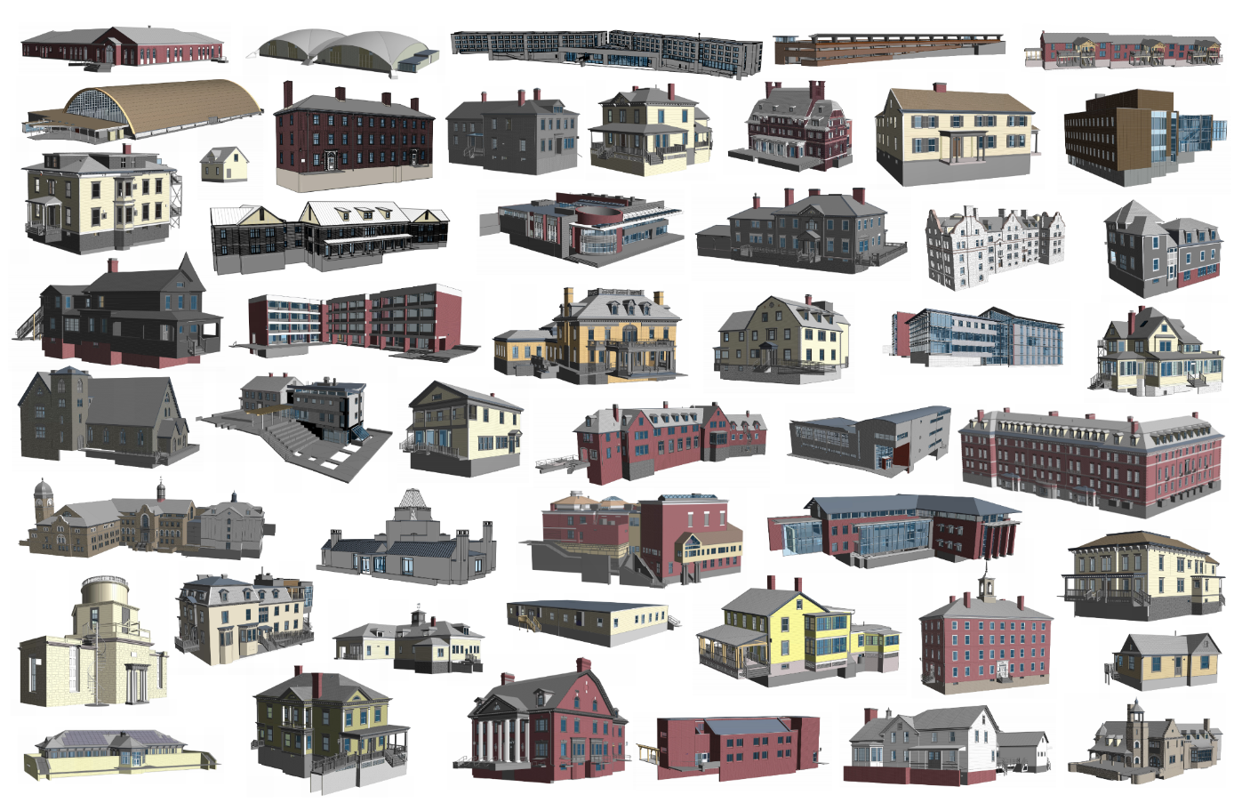
Many types of companies and organizations work with the experts at Existing Conditions to solve a wide variety of complex challenges like these:
- Ensuring your cross-disciplinary teams can do their best work by facilitating collaboration, managing complex multi-stage projects, and preparing models for contractors through preliminary BIM setup work to support their initiatives
- Using sophisticated templates to quickly integrate into your way of working
- Setting up file organization and management systems to keep your department in sync
- Coding of plans and drawings to work with your firm's naming conventions
- Regular update and maintenance of project files to stay up to date with the current state of your building by incorporating any subsequent iterations and archiving previous versions
- Creation of customized floor area plans including basic data entry, square footage calculations, and updates
- Maintain project consistency through regular meetings to review current work orders and discuss future project initiatives with senior Product, Technology, and/or Support staff from Existing Conditions
- Secure data storage and digital file management to ensure archived files will remain accessible beyond project delivery, as well as assistance sharing point cloud and BIM data with your partners and collaborators in a safe and secure way
- Guidance regarding file management best practices, threats, risks, and potential opportunities
Existing Conditions 3D Laser Scanning Services
Over the past 27 years, we have measured, documented, and modeled over 10,000 buildings spanning over 700 million square feet across the United States, establishing ourselves as an industry leader in 3D laser scanning. Architects, builders, engineers, developers, facility managers, trust us to deliver digital representations of the as-built environment with unparalleled accuracy and efficiency. Our dedicated Project Managers provide fast and accurate 3D laser scanning services and drone imagery services, and expert CAD and BIM technicians create custom, detailed deliverables. Our greatest reward remains delivering superior-quality scan-to-BIM work and knowing we played a vital role in our clients’ unique and historic projects.
Explaining As-Built Documentation
As-built drawings, also known as as-built documentation, record drawings or red-line drawings, provide a detailed representation of the building as actually constructed. This documentation facilitates a compare-and-contrast between the building as designed versus the building's final specifications. In reality, very few buildings are perfect manifestations of their original construction documents.
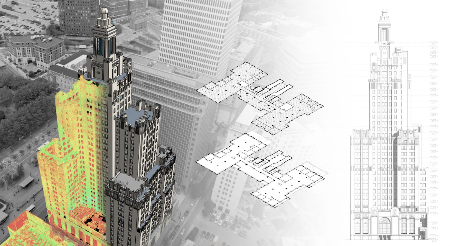
As-built drawings are a set of drawings the contractor submits when they've finished a project. These drawings should reflect any changes in specifications from working drawings during the construction process. They also show dimensions, geometry, and locate all of the elements of the tasks completed under the contract.
As-built documentation provides a comprehensive, post-construction view of a building, ensuring that the final product is meticulously captured and recorded. In contrast to original construction plans, As-builts depict the building as it stands upon project completion, encompassing any changes made during the construction process.
Importance of As-Built Drawings
- Accountability and Clarity: These drawings offer a transparent record of any deviations from the initial design, ensuring clarity and accountability among stakeholders.
- Future Reference: They serve as an invaluable reference for future renovations, modifications, or facilities management activities. Having an accurate record can aid in faster decision-making and reduces the risk of errors.
- Legal and Compliance: In certain jurisdictions, As-built documentation is mandatory for compliance with building codes and regulations.
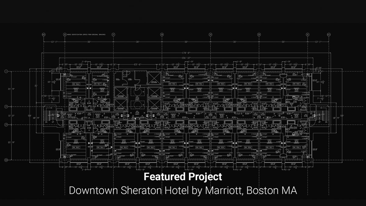
Components of As-Built Documentation
- Field Changes: Any alterations made on-site during the construction process. This could include adapting to unforeseen site conditions or modifications due to material availability.
- Shop Drawing Changes: Alterations made during the fabrication process of specific building components, such as custom windows or specialty equipment.
- Modifications: Any changes that were not part of the original design but were implemented for practical, aesthetic, or other reasons.
- Design Changes: Updates or revisions made to the initial architectural or engineering designs after construction has started.
- Extra Works: Additional tasks or components added to the project which were not part of the initial contract or scope.
- High-Definition Laser Scanning: Leveraging state-of-the-art technology, high-definition laser scanning offers precise, detailed, and rapid data capture of the built environment. This technology captures and documents even the minutest details, ensuring that the As-built documentation is as accurate as possible.
As-built documentation plays a critical role in the construction industry, bridging the gap between design intent and actual construction. Leveraging technological advances like laser scanning, companies like Existing Conditions can now capture the built environment with unprecedented accuracy. This ensures that stakeholders, be they architects, owners, or builders, have a reliable point of reference for any future endeavors related to the structure.
Learn More About Existing Conditions As-Built Drawing Services>
Existing Conditions 3D Laser Scanning Services
Over the past 27 years, we have measured, documented, and modeled over 10,000 buildings spanning over 700 million square feet across the United States, establishing ourselves as an industry leader in 3D laser scanning. Architects, builders, engineers, developers, facility managers, trust us to deliver digital representations of the as-built environment with unparalleled accuracy and efficiency. Our dedicated Project Managers provide fast and accurate 3D laser scanning services and drone imagery services, and expert CAD and BIM technicians create custom, detailed deliverables. Our greatest reward remains delivering superior-quality scan-to-BIM work and knowing we played a vital role in our clients’ unique and historic projects.
Explaining BOMA, and Other SF Calculations
Existing Conditions is committed to providing the best as-built documentation in the industry. That's why we provide Gross Square Footage* calculations for each floor in our standard deliveries.
If you need a more detailed breakdown of building areas, make sure our Business Development team knows this before writing their proposal. We will also need a markup of how you would like the spaces divided (this can be done after we send you the Floor Plans, even as modeling continues). While a written description of how you want the spaces divided can be helpful, there is no substitute for clearly-marked drawings. Please note that subdivided SF calculations may require an additional fee.
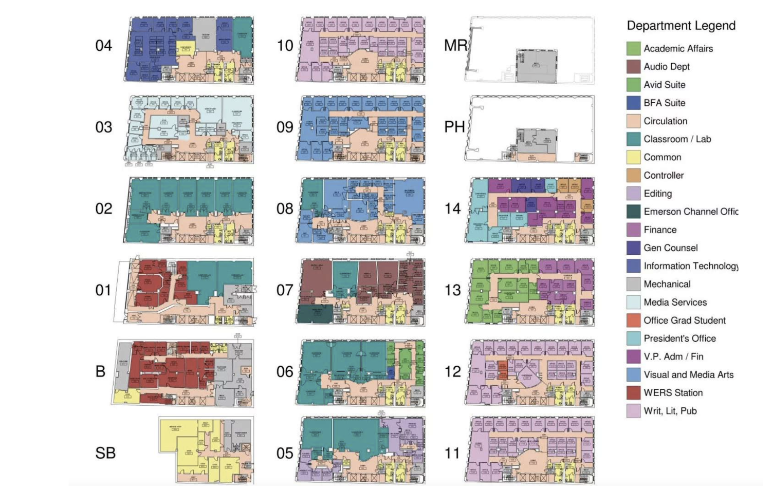
Existing Conditions does not typically provide BOMA Calculations or Condo Docs. These calculations are a constantly-evolving set of legal standards and classifications. We instead focus on what we do best - documenting the architectural built environment.
*Measured to the exterior face of exterior walls and presumed center of demising walls; not applicable for all projects
Existing Conditions 3D Laser Scanning Services
Over the past 27 years, we have measured, documented, and modeled over 10,000 buildings spanning over 700 million square feet across the United States, establishing ourselves as an industry leader in 3D laser scanning. Architects, builders, engineers, developers, facility managers, trust us to deliver digital representations of the as-built environment with unparalleled accuracy and efficiency. Our dedicated Project Managers provide fast and accurate 3D laser scanning services and drone imagery services, and expert CAD and BIM technicians create custom, detailed deliverables. Our greatest reward remains delivering superior-quality scan-to-BIM work and knowing we played a vital role in our clients’ unique and historic projects.
Explaining Existing Conditions Drone Services
The role of drones in reality capture and building documentation continues to evolve rapidly every year. With billions of dollars in research and development going towards the unmanned aerial vehicle industry, many previously cost-prohibitive services are now within reach of most professionals within our industry.
Existing Conditions' FAA-certified pilots can help you leverage drones to the fullest. When combined with an exterior building scan using terrestrial 3D laser scanning, clients often find our aerial drone surveys to be a great alternative to a full 3D Revit model or CAD exterior elevations.
Types of Drone Data
There are two primary types of data sets that can be captured and delivered using drones: visual media, and photogrammetric models. Drone media primarily consists of high-definition digital photographs and video clips. Photogrammetric models are digital 3D models that are created using photographic data to determine the characteristics of the built environment. Both types of data sets can help document buildings when cost, accessibility and safety are top priorities.
If you have special flight specifications for our FAA-certified pilots, we request that you provide as much detail as possible for our team to use as reference.
Visual Media
Through Existing Conditions' drone flight operations, our FAA-certified team can capture data over a large physical area in a relatively short amount of time. These data sets will often contain hundreds of high-resolution digital images and video clips. Leveraging this set of visual media can reduce time on site and in processing, saving our clients on the overall cost and schedule of their projects. When it comes to accessibility, drones allow our team to visually access spaces where terrestrial 3D laser scanning may not be viable.
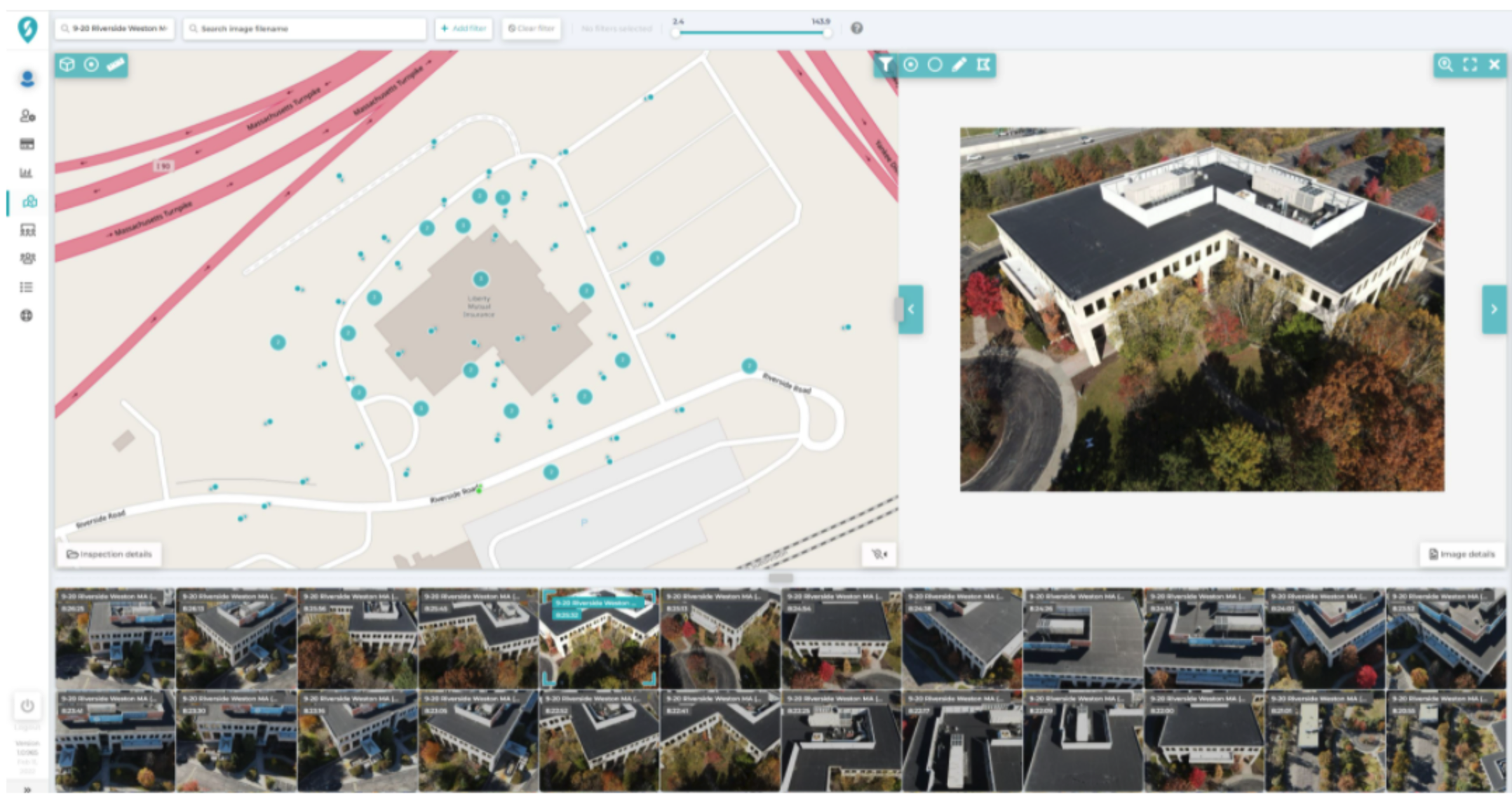
For example, if a building is abutting a body of water, or if there is no adequate access to the rooftop, our FAA-certified team can use a drone to augment other components of the data set. Safety is always a top concern for our field operations teams, as well as our on-site partners, and drones can mitigate the necessary exposure of crews to unsafe conditions such as fire damage, decaying infrastructure, or hazardous air quality.
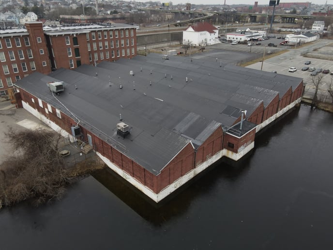
Once our team has captured a satisfactory set of visual data, we are able to collate that information, analyze it, and report on it. This process allows for delivery of both an online and PDF report. Our team effectively turns visual inspection images into valuable asset insights, saving our clients time and money. Visual analysis is another tool in our toolbox. Just as a 3D laser scanner has its own strengths, there are instances where a visual survey via drone will provide a client with the best data for their needs. This is often the case when a client needs to perform a visual assessment of a facade or roof but does not need measured drawings to do so. In these scenarios, high-resolution visual media captured by drone is the best approach for the job.
Visual surveys also can be tied to the specific date of capture. When flights are executed repeatedly, clients benefit from the increased insights that come through repeat inspections. Whether a new building is inspected for construction progress, or a roof is inspected to determine the rate of deterioration, historic comparisons allow clients to understand how time impacts their projects.
Photogrammetric Models
Photogrammetry refers to the science of using photographs to generate a set of accurate measurements. Existing Conditions can leverage sets of photographs and use photogrammetry to build a digital 3D model that helps clients save on cost in a variety of ways. Performed at the beginning of a project during the due diligence phase, clients can use photogrammetric models to avoid being forced to erect scaffolding in order to adequately survey the upper levels of a building's façade. Façade documentation by drone survey can provide a detailed perspective of every square foot of a building in a high resolution color image. Drones allow access to the out of reach upper floors of a high-rise that can not be reached with traditional scanning, allowing the client to save time and money. Given that the massing of many high rise buildings are "stepped-back" as the building rises, a drone survey provides a perspective that would otherwise be unattainable from street level.
Our Visual Media Deliverables
We typically deliver a minimum of 15 high-resolution aerial images and 5 high-definition aerial video clips, though our work is always driven by the client's scope. For some projects, we are also capable of delivering an accessible online 3D model to use for facade and roof inspection (example above).
For quality control purposes, our FAA-certified pilots are provided with a standard set of instructions.
- Standard Shot List
- Images are captured at 100' and 350' from the cardinal directions (N, NE, E, SE, E, SW, W), according to FAA height restrictions and project scope
- Panoramas will be taken at 100', according to FAA height restrictions and project scope
- Videos are captured from a variety of different angles and altitudes to provide multiple perspectives of the property. We often work closely with our clients to highlight specific areas of the property or local features in the project vicinity.
- Standard Time
- The flight time is typically between 11 AM and 2 PM in order to work in optimal lighting conditions. If you would like to request that we capture imagery and video at a specific time frame, simply let us know in advance. Please note that flights completed outside the typical 11 AM - 2 PM time frame may be subject to harsh shadows or glare, due to the fact that the sun will be lower in the sky.
Please note that adverse weather conditions or supplemental requirements may lead to an extended timeline for the imagery delivery as our FAA-certified pilots may need to reschedule in order to fly safely and capture the best imagery possible.
For specific requests around preferred date and time, we will do our best to accommodate your specific needs.
Download e-Book on Existing Conditions Drone Surveys
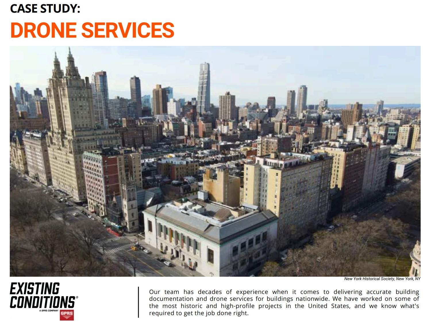
Existing Conditions Drone Survey Services
Over the past 27 years, we have measured, documented, and modeled over 10,000 buildings spanning over 700 million square feet across the United States, establishing ourselves as an industry leader in 3D laser scanning. Architects, builders, engineers, developers, and facility managers, trust us to deliver digital representations of the as-built environment with unparalleled accuracy and efficiency. Our dedicated Project Managers provide fast and accurate 3D laser scanning services and drone imagery services, and expert CAD and BIM technicians create custom, detailed deliverables. Our greatest reward remains delivering superior-quality scan-to-BIM work and knowing we played a vital role in our clients’ unique and historic projects.
Contact us today for a free project estimate.
Explaining Existing Conditions' Convenient Billing Options
Explaining Existing Conditions' Convenient Billing Options
Once a project has progressed to the QC phase, we set up billing for our clients.
We provide secure links to see the invoice for your project that can also easily be downloaded as a PDF and printed for your records.
This invoice can be paid online via:
- Credit
- Debit
- ACH
- Wire transfer
If you have any questions about invoicing, reach out any time to our team – we're here to help! You can reach us at invoice@existingconditions.com or by phone at +1-617-247-9161.
If you'd like to learn more, visit our portfolio, or contact us to connect with a member of our team.
Explaining Existing Conditions' Deliverable Formats
Tailored Deliverable Formats
At Existing Conditions, our mission is to cater to your specific project scope and needs. Our deliverables are meticulously crafted to align with your requirements, ensuring that you receive precisely the information and documentation you need. Here's a closer look at our approach:
Customized Level of Detail
We understand that no two projects are identical, and as such, our deliverables are tailored to match the level of detail essential for your project's success. Our commitment to customization means that we can adjust our measuring and modeling process to suit your specific needs.
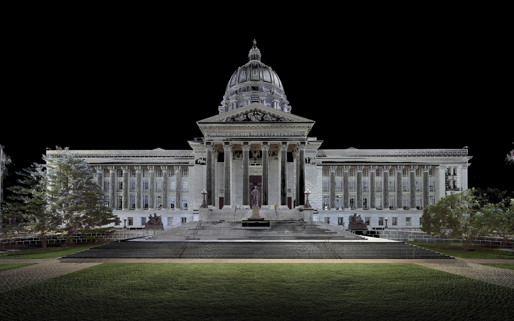
Transparent Project Quoting
When you request a project quote from us, we provide you with a clear breakdown of what will be included in the drawings and the scope of our work. This transparency ensures that you have a comprehensive understanding of what to expect from our services.
Collaborative Review Process
Before we embark on creating CAD drawings or BIM models for you, our dedicated BIM managers will engage in a collaborative review process with you. This step is crucial for ensuring that we maximize situational awareness and meet your expectations. We take your input seriously and use it to refine our approach.
Commonly Requested Drawings
While our deliverables can be tailored to your unique needs, there are five types of drawings that our clients most commonly request:
- Floor plans - Providing a comprehensive view of a building's layout, floor plans are instrumental in understanding spatial arrangements.
- Roof plans - These plans offer insights into the rooftop layout, critical for architectural and structural considerations.
- Exterior elevations - Exterior elevations provide a detailed depiction of the building's exterior, assisting in design and facade assessments.
- Reflected ceiling plans - RCPs highlight ceiling details, essential for interior design and lighting planning.
- MEP plans (mechanical, electrical, and plumbing equipment) - These plans cover the locations and details of mechanical, electrical, and plumbing systems, vital for construction and maintenance.
Diverse Delivery Formats
We provide flexibility in delivering 3D laser scan data, with our drawings primarily offered in Autocad .DWG file or Revit .RVT file formats. However, we can also export to various CAD platforms and offer PDF format for your convenience.
Explore Our Complete List of Deliverables
For a comprehensive overview of our deliverable options and how they can align with your project, you can review our complete list of deliverables on our website.
If you'd like to learn more, visit our portfolio, or contact us to connect with a member of our team.
Explaining Existing Conditions' Virtual Site Visits Platform
Existing Conditions' Virtual Site Visits platform is an easy and low-cost way to access spatial data of your building or project – from any device and without any burdensome downloads. We take the measurements captured by our team on-site and turn this reality capture data into an easy-to-use digital twin. In effect, our approach transforms buildings and assets into intelligent spaces for owners, facilities managers, architects, and contractors.
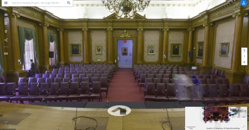
With Existing Conditions' Virtual Site Visits platform, point clouds of buildings and assets are transformed into web-based spaces for every stakeholder working on your project. The result is a digital twin for smart collaboration and decision making, closing the gap between the physical and digital world.
- User-friendly and intuitive design makes digital buildings accessible to every stakeholder
- Make informed decisions and avoid rework with real world representations of as-is conditions
- Smart remote collaboration tools enable improved efficiency in planning, design, engineering, and operations
- Whether remote or on-site, interacting with the digital twin allows teams to better understand what they are truly working with
Existing Conditions 3D Laser Scanning Services
Over the past 27 years, we have measured, documented, and modeled over 10,000 buildings spanning over 700 million square feet across the United States, establishing ourselves as an industry leader in 3D laser scanning. Architects, builders, engineers, developers, and facility managers, trust us to deliver digital representations of the as-built environment with unparalleled accuracy and efficiency. Our dedicated Project Managers provide fast and accurate 3D laser scanning services and drone imagery services, and expert CAD and BIM technicians create custom, detailed deliverables. Our greatest reward remains delivering superior-quality scan-to-BIM work and knowing we played a vital role in our clients’ unique and historic projects.
Explaining Interior Elevations
Explaining Interior Elevations
Both commercial and residential projects sometimes require additional interior detail. The design planning phase often includes drawing design elevations to help determine where to place objects and other elements within a given space. This can help a team envision the commercial building designs or house plans as a whole.
While your specific project needs may differ, typically these building elements and finished spaces that are visible and accessible during our survey will be modeled orthogonally at a moderate level of detail:
- Interior walls
- Window mullions
- Fireplaces
- Casework (built in Cabinetry, Countertops & Bookshelves)
- Windows, doors, and curtain wall
- Changes in material noted
- Built-in casework
- Crown and base molding
- Ceilings and floors delineated
An interior elevation is an orthographic projection—a two-dimensional representation of a three-dimensional space. This two-dimensional drawing of a wall (or series of walls) can have varying degrees of detail. Interior elevations can help give the team a front or side view of a room, developing in complexity as details are added throughout the project. They are often used to determine where appliances or built-ins should be positioned.
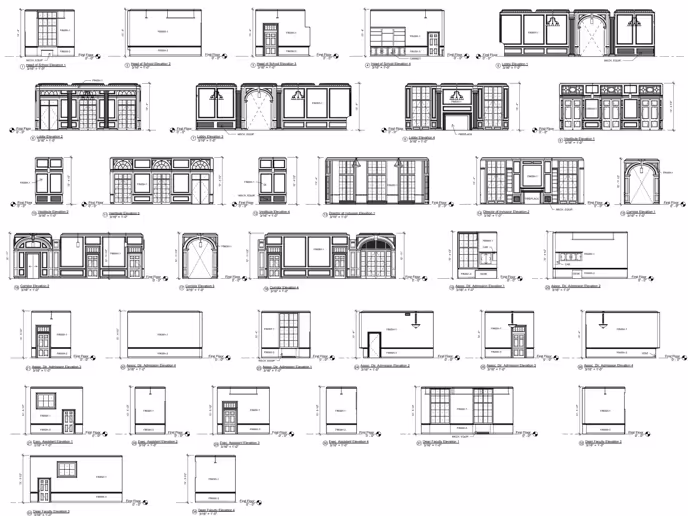
By creating an interior elevation drawing, you can figure out the placement of things like furniture, fixtures, ceiling height, or other decor you plan on including in your final design. Elevations are usually scaled drawings, and present a layout of a room on a vertical plane—from floor through the horizontal line to the ceiling—giving a more accurate idea of where and how things will fit together.
An elevation gets you inside the space and is great for seeing more specific details from eye level. This makes an elevation especially useful for kitchen design and other types of renovation. With an elevation, you can see details like where appliances would be positioned and the movement of your furniture (for example, the particular direction the doors swing on your cabinetry or how far a drawer will pull out). While a floor plan offers a general layout of the room design, the elevation drawing gets the viewer inside the room, and able to see a clearer picture of how it will look upon completion.
If you'd like to learn more, visit our portfolio, or contact us to connect with a member of our team.
Explaining Pre-Construction Survey & 4D Survey
If proper existing documentation of neighboring buildings is not done before the start of a construction project, it could lead to insurance claims and litigation.
Using the latest in 3D laser scanning technology, Existing Conditions can document the conditions of neighbors at a specific time before construction starts. This will allow you to have a document that you can rely on to show if any damage has taken place.
Some consider this to be a 4D survey – the fourth dimension being time. This is because the reality capture data is tied to that specific moment in time when the surveying occurred. For sites where the passage of time may play a critical factor, having that level of certainty is valuable.
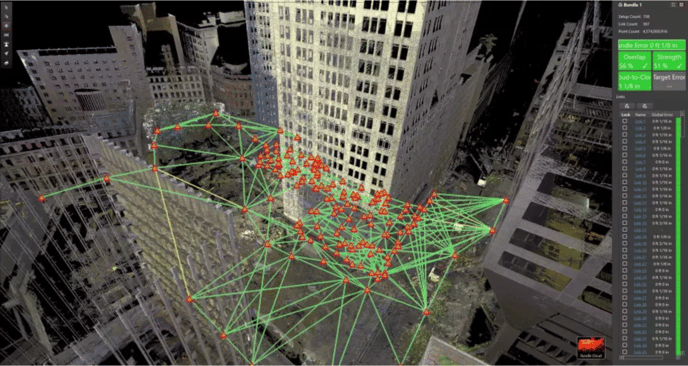
Existing Conditions 3D Laser Scanning Services
Over the past 27 years, we have measured, documented, and modeled over 10,000 buildings spanning over 700 million square feet across the United States, establishing ourselves as an industry leader in 3D laser scanning. Architects, builders, engineers, developers, facility managers, trust us to deliver digital representations of the as-built environment with unparalleled accuracy and efficiency. Our dedicated Project Managers provide fast and accurate 3D laser scanning services and drone imagery services, and expert CAD and BIM technicians create custom, detailed deliverables. Our greatest reward remains delivering superior-quality scan-to-BIM work and knowing we played a vital role in our clients’ unique and historic projects.
Florida 3D Laser Scanning Services
Delve into a comprehensive overview of the 3D laser scanning projects we've completed across the Miami metropolitan area. Contact Existing Conditions for Miami & Palm Beach 3D Laser Scanning Services. Our team has decades of experience when it comes to delivering accurate building documentation for buildings nationwide. We have worked on some of the most historic and high-profile projects in the United States, and we know what's required to get the job done right.
1836 Biscayne Boulevard
DSS Consulting selected Existing Conditions to scan and document this historic church, with the objective of transforming it into a retail space within a 40-story residential tower.
Using the Leica RTC360 laser scanner, we scanned the vacant historic site, capturing every detail of the church with precision. The data collected eliminated the need for additional site visits, saving time and resources. By delivering a 3D Revit model and various plans, our client was able to begin their redevelopment project with confidence.
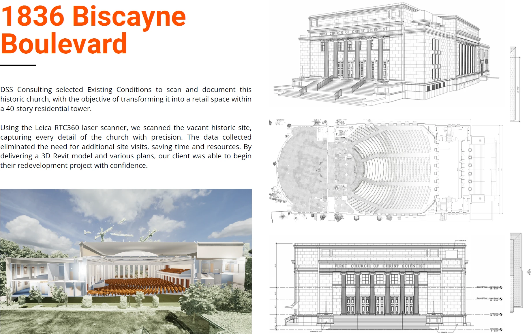
Bacardi Rum Co., Home Office
Nestled in Miami's lively South Beach, The Bacardi Rum Company's headquarters is a mid-century modern office building adorned with intricate stained glass and mosaic tiles.
Selected by STA Architectural Group, a Miami-based firm, Existing Conditions scanned this architectural masterpiece and provided our cleint with a comprehensive BIM model, showcasing the historical significance of this structure.
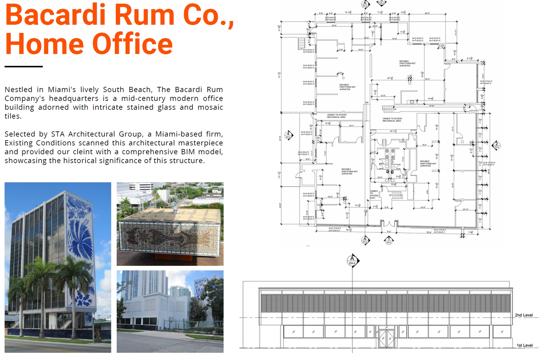
The Colony Hotel
Existing Conditions was selected to survey this captivating hotel, in Palm Beach, Florida. Using the Leica RTC360 scanner, our team successfully scanned 125,000 square feet of space, including 79 guest rooms, each possessing its own distinct and individual character.
With a strong focus on execution and client satisfaction, Existing Conditions exceeded expectations, providing accurate data and accommodating additional requests from the client. The successful completion of this project demonstrated Existing Conditions’ commitment to excellence and solidified our reputation as trusted partners in the industry.
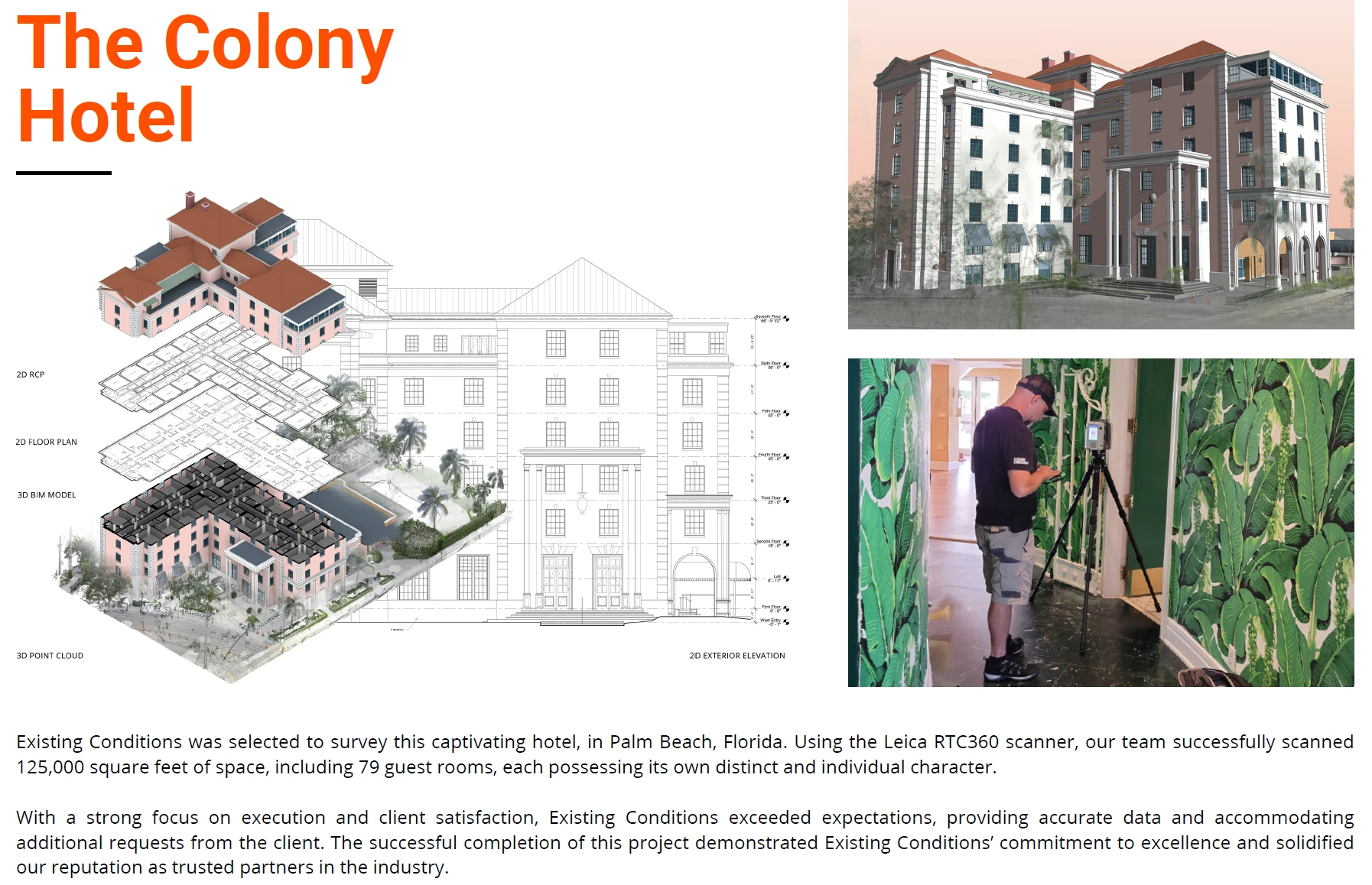
Norton Museum of Art
The Norton Museum of Art in Palm Beach, Florida, presented a truly captivating project—a one-of-a-kind endeavor.
Beyond engaging us for our standard scope of 3D laser scanning and the creation of a BIM model for their existing structure, the museum entrusted us with an additional task. We were asked to scan various pieces of artwork and landscape features that are essential to the character of the building.
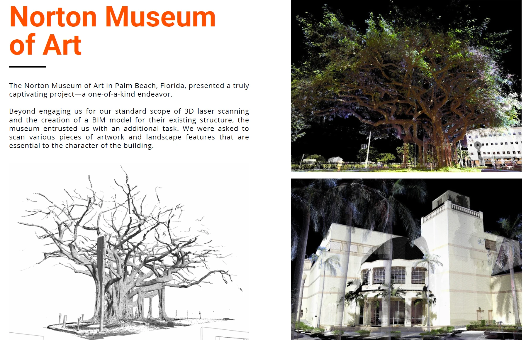
Palm Beach Country Club
The majority of our Existing Conditions team possesses architectural backgrounds and an appreciation for interior design. Observing the way past generations catered to high-end tastes at The Palm Beach Country Club was inspiring.
Existing Conditions was chosen to conduct a comprehensive scan of 66,000 square feet of this property, utilizing the Leica RTC360. Our team successfully executed the scanning process, delivering accurate existing floor plans essential for future renovations.
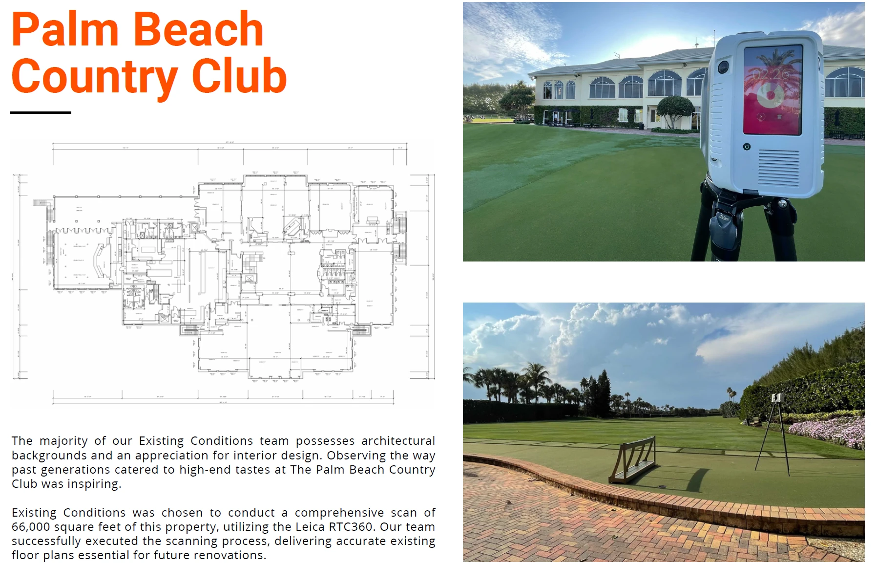
The Royal Poinciana Plaza
Situated in Palm Beach, Florida, the Royal Poinciana Plaza is an upscale retail facility. This project came to us when a Boston-based development team, newly in possession of the property, enlisted our services.
This project posed considerable challenges due to the multitude of tenants associated with the property. However, navigating such scenarios is one of our expertise. Handling similar situations regularly, we excel in executing the fieldwork aspect of the project, getting the client what they need on time and within budget.
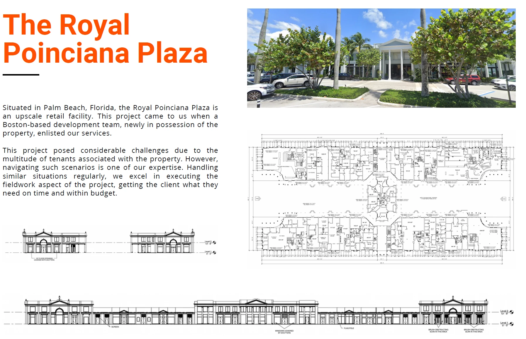
Portfolio
By using the latest 3D laser scanning technologies, proprietary workflows, and a highly trained staff, we have built an expansive portfolio of more than 10,000 buildings over the past 27 years. We're passionate about our work, and it shows. Leverage our experience, equipment, and expertise.
Existing Conditions 3D Laser Scanning Services
Over the past 27 years, we have measured, documented, and modeled over 10,000 buildings spanning over 700 million square feet across the United States, establishing ourselves as an industry leader in 3D laser scanning. Architects, builders, engineers, developers, and facility managers, trust us to deliver digital representations of the as-built environment with unparalleled accuracy and efficiency. Our dedicated Project Managers provide fast and accurate 3D laser scanning services and drone imagery services, and expert CAD and BIM technicians create custom, detailed deliverables. Our greatest reward remains delivering superior-quality scan-to-BIM work and knowing we played a vital role in our clients’ unique and historic projects.
General Contractors Benefit From 3D Laser Scanning Services
For decades, builders and general contractors have worked with Existing Conditions to 3D laser scan buildings and project sites.
Existing Conditions 3D laser scanning provides a solution to outdated as-built data and drawings through the use of survey-grade laser scanners, delivering site data that is complete, clean and accurate. Since as-built drawings are often misdrawn, poorly kept, or even lost, site documentation has been perfected through Existing Conditions' 3D laser scanning expertise. With the capacity to create a true digital twin, Existing Conditions provides accurate reality capture data fast and efficiently.
Builders and general contractors can use 3D laser scanning to accurately capture existing site conditions, allowing for precise measurements and detailed 3D BIM models, which helps to minimize errors, improve project planning, identify potential clashes, and ensure the construction project aligns perfectly with the design, ultimately leading to reduced rework and increased efficiency throughout the building process.
Point Clouds, As-Built Drawings & 3D BIM Models
Existing Conditions specializes in capturing 3D laser scan data and works to provide clients with intelligent deliverables to enhance the understanding of their site and informs decision-making at all levels.
These deliverables take on a variety of forms, but by far the most common is the initial form of raw data, the point cloud. By using state-of-the-art Leica laser scanners, Existing Conditions collects site data in individual points and creates a point cloud. Existing Conditions then takes these point clouds and produces custom deliverables for a project. Deliverables such as 3D BIM models, 2D CAD drawings, and more are created of the site detailing structural, architectural, and MEP features.
Using just the point cloud data, builders and general contractors can easily view infrastructure, potential conflicts, and more. And a comprehensive 3D BIM model provides even more benefits, including the ability to do a virtual walk-through of the entire site.
Existing Conditions 3D Laser Scanning offers an opportunity for builders and general contractors to rework outdated plans to negate the inherent risks, inferences and clashes before they happen. With Existing Conditions, these risks are mitigated, as we provide 2-4 mm accurate data and complete scans of entire sites. Using the deliverables mentioned above, Existing Conditions helps contractors take control of the project site by avoiding costly change orders and delays.
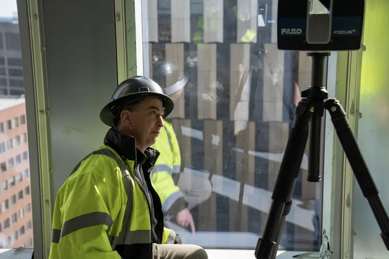
How Do Builders and General Contractors Benefit from 3D Laser Scan Technology?
- Accurate Information: Provide stakeholders with accurate, up-to-date information throughout a project and give them a chance to adjust their plans before expensive work begins.
- Visualization: Get a visual of the final result before construction even begins and make more informed decisions as you go.
- Communication: A digital footprint of a project makes communication and collaboration much more efficient. Projects and plans can be reviewed remotely, from anywhere in the world.
- Safety: With laser scanning and BIM, you can spot hazards or construction vulnerabilities without ever stepping on site. Fewer site visits also mean helping to safeguard clients from on-site hazards.
Existing Conditions 3D Laser Scanning Services
Over the past 27 years, we have measured, documented, and modeled over 10,000 buildings spanning over 700 million square feet across the United States, establishing ourselves as an industry leader in 3D laser scanning. Architects, builders, engineers, developers, facility managers, trust us to deliver digital representations of the as-built environment with unparalleled accuracy and efficiency. Our dedicated Project Managers provide fast and accurate 3D laser scanning services and drone imagery services, and expert CAD and BIM technicians create custom, detailed deliverables. Our greatest reward remains delivering superior-quality scan-to-BIM work and knowing we played a vital role in our clients’ unique and historic projects.
Greyscale Laser Scanning vs. Color Laser Scanning
Explaining the Difference Between Greyscale & Color Laser Scanning
The default mode for construction-grade 3D laser scanning is greyscale. This refers to the coloring of the point cloud inside of Revit and TruView/JetStream. When the scanner captures the data, it assigns a greyscale value from 0-100 based on the reflectivity of the object and the angle of incidence.
The 3D laser scanner does not need the spaces to be lit in order to capture this information – it can work in pitch dark.
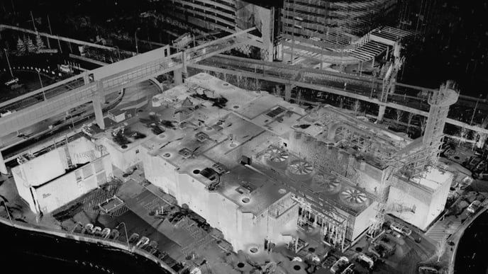
The 3D laser scanner also has built-in digital cameras that can capture the color of the space as well as its details. The scanner performs a second rotation after the initial scanning is completed and takes 100's of small pictures that it then stitches together to form a full, color, stereoscopic picture at the point of the scan. The software then colorizes the 3D points based on this stereoscopic image so the end result is a full color 3D point cloud.
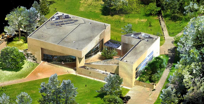
Those stereoscopic pictures can also be turned on and off within the TruView/JetStream viewer for better visualization. The 3D laser scanner needs the spaces to be well lit in order to capture these pictures.
Color scanning takes three times as long as typical greyscale scanning and also increases the file size of the TruView/JetStream data dramatically. There is typically an increase in fee for this service. Please reach out to your sales representative to inquire about color scanning for your project.
If you'd like to learn more, visit our portfolio, or contact us to connect with a member of our team.
Hardware Requirements
Hardware Requirements
Windows hardware is the best, and in many cases, the only appropriate hardware for viewing point cloud data.

Leica Scans
To view data from a Leica scanner, you will need TruView/Jetstream software on a Windows PC.
FARO Scans
Scene LT software
A Windows PC with a dedicated video card (not compatible with on-board Intel video cards) is required for viewing Scene LT scanner data. Most laptops do not have a dedicated video card, however if it does, you have the option to change which video card the Scene LT software uses. Be sure to set Scene LT to the dedicated video card rather than the "integrated video card.” These dedicated video cards are usually from Nvidia or Radeon.
Scene2Go
Scene2Go software on a Windows PC is another option for viewing FARO scanner data. Please note an additional cost may be associated with providing this format of scan data.
Healthcare Building and Hospital 3D Laser Scanning Services
With a rich history spanning decades, our team excels in the realm of delivering precise building documentation for medical facilities and hospitals. Throughout our journey, we've been honored to 3D laser scan some of the most prestigious and historically significant hospital projects in the United States. This extensive experience has bestowed upon us an unparalleled understanding of the unique intricacies and demands associated with healthcare infrastructure.
Medical buildings and hospitals stand as pillars of society's well-being, demanding documentation of the utmost accuracy and reliability. We recognize that these structures house critical elements of healthcare delivery, from state-of-the-art medical equipment to patient care units, and each component requires meticulous attention to detail.
Our commitment to 3D laser scanning excellence extends beyond the architectural aspects, encompassing the intricate network of mechanical, electrical, and plumbing systems that power these life-saving institutions. We understand that accuracy in documentation is not just a matter of compliance but a cornerstone of patient safety and efficient healthcare operations.
By leveraging our extensive 3D laser scanning experience and unwavering dedication to precision, we consistently deliver building documentation that meets and exceeds the stringent standards of the medical sector. Whether it involves preserving the historic legacy of a renowned hospital or facilitating the construction of a cutting-edge medical facility, our team possesses the expertise required to ensure the job is done right, safeguarding the health and well-being of countless individuals.
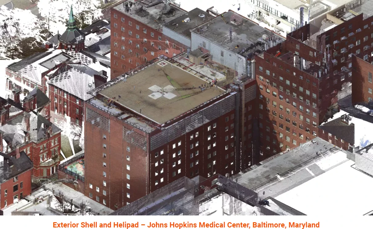
Medical Facility Experience and Expertise
Our team has decades of experience when it comes to delivering accurate building documentation for medical buildings. We've had the privilege to work on some of the most historic and high-profile medical facilities in the United States, and we know what's required to get the job done right. Below is a selection of relevant projects we have measured and modeled in recent years.
1. Johns Hopkins Medical Center, Baltimore, Maryland
2. Brigham and Women's Hospital, Boston, Massachusetts
3. Massachusetts General Hospital, Boston, Massachusetts
4. Rex Medical Center, Durham, North Carolina
5. Tufts University Medical Center, Boston, Massachusetts
6. Boston University Medical Center, Boston, Massachusetts
7. Rhode Island Hospital, Providence, Rhode Island
8. New York University Langone Medical Center, New York, New York
9. Stamford Medical Center, Stamford, Connecticut
10. Beth Israel Deaconess Medical Center, Boston, Massachusetts
Existing Conditions 3D Laser Scanning Services
Over the past 27 years, we have measured, documented, and modeled over 10,000 buildings spanning over 700 million square feet across the United States, establishing ourselves as an industry leader in 3D laser scanning. Architects, builders, engineers, developers, facility managers, trust us to deliver digital representations of the as-built environment with unparalleled accuracy and efficiency. Our dedicated Project Managers provide fast and accurate 3D laser scanning services and drone imagery services, and expert CAD and BIM technicians create custom, detailed deliverables. Our greatest reward remains delivering superior-quality scan-to-BIM work and knowing we played a vital role in our clients’ unique and historic projects.
Existing Conditions 2D CAD Drawing & 3D BIM Model Deliverables
Architectural Layouts: Floor plans, elevations, sections, and RCPs showing the current configuration of walls, doors, windows, and more to document a building’s layout.
Structural Details: Up to date information about load-bearing walls, beams, columns, and foundation systems to understand a building's structural integrity and constraints.
Building Dimensions: Accurate measurements of all spaces, including heights, widths, and depths to avoid discrepancies during design.
MEP Systems: Location and layout of HVAC systems, electrical wiring, plumbing, and fire protection systems for redesign or upgrades.
Material Specifications: Details on existing materials used in walls, floors, roofs, and finishes for construction or renovation planning.
Condition Assessments: Documentation of the building’s current condition, identifying issues such as cracks, leaks, or wear that may require attention.
High-Definition 3D Laser Scanning
Existing Conditions specializes in providing survey-grade XYZ coordinates of the built world using high-definition 3D laser scanning technology. Our expertise extends to capturing accurate three-dimensional data in diverse settings, whether it's 3D laser scanning buildings, hospitals, universities, refineries, or even non-building elements like submarines, boats, and statues.
Key highlights of our high-definition 3D laser scanning services include:
- Versatile Applications: Our scanning capabilities are not limited by size or surface features. We excel at surveying large-scale structures and have the flexibility to capture data in various environments.
- As-Built Documentation: High-definition surveying is a valuable tool for digitizing as-built construction, making it ideal for documenting existing structures and gathering data for proposed additions or reconstructions. This detailed approach ensures precision and accuracy in your project.
- Construction Oversight: During construction projects, we offer laser scanning services to monitor progress and verify that the design is being executed correctly. This proactive approach helps identify and address potential issues early in the construction phase.
- Beyond Buildings: Our expertise extends beyond traditional building structures. We have successfully scanned diverse elements of the built environment, including submarines, boats, statues, and more. This versatility allows us to cater to a wide range of client needs.
At Existing Conditions, we take pride in our ability to deliver survey-grade XYZ coordinates, enabling you to access precise spatial data for your projects. Whether it's for architectural, construction, or non-building purposes, our high-definition 3D laser scanning services are designed to meet your unique requirements with accuracy and efficiency.
Existing Conditions 3D Laser Scanning Services
Over the past 27 years, we have measured, documented, and modeled over 10,000 buildings spanning over 700 million square feet across the United States, establishing ourselves as an industry leader in 3D laser scanning. Architects, builders, engineers, developers, and facility managers, trust us to deliver digital representations of the as-built environment with unparalleled accuracy and efficiency. Our dedicated Project Managers provide fast and accurate 3D laser scanning services and drone imagery services, and expert CAD and BIM technicians create custom, detailed deliverables. Our greatest reward remains delivering superior-quality scan-to-BIM work and knowing we played a vital role in our clients’ unique and historic projects.
Historic Landmark 3D Laser Scanning Services
Our team boasts decades of expertise in 3D laser scanning historic landmarks. We consider it a privilege to have contributed our 3D laser scanning services to some of the most iconic projects in the United States, and we possess an in-depth understanding of the exacting standards needed to excel in this field.

Preserving Heritage: Historic landmarks hold a unique place in our cultural tapestry. We approach each project with the utmost reverence for preserving the rich heritage these landmarks represent. Our methods blend advanced technology with a deep appreciation for historical significance.
Heritage Conservation: Documenting historic landmarks involves more than just data collection; it requires a commitment to heritage conservation. We take great care to ensure that our documentation not only captures the essence of these landmarks but also aids in their preservation for future generations.
Historical Accuracy: Accuracy is paramount when documenting historic sites. Our team's extensive experience ensures that every detail, no matter how intricate, is faithfully recorded to provide a true-to-life representation.
Minimized Disruption: We understand the importance of minimizing disruption during historic landmark documentation. Our streamlined processes and efficiency mean that we can capture the necessary information without causing undue interruption to these cherished sites.
Experienced Professionals: Our team comprises seasoned professionals who specialize in the documentation of historic landmarks. With our expertise, we help safeguard these invaluable pieces of our collective history.
When it comes to precise as-built documentation for historic landmarks, you can trust our team's wealth of 3D laser scanning experience and unwavering commitment to ensure the job is executed to the highest standards. We take pride in contributing to the preservation and celebration of our nation's historical treasures.
Historic Landmarks 3D Laser Scanning Experience and Expertise
Our team has decades of experience when it comes to delivering accurate building documentation for historic landmarks. We've had the privilege to work on some of the most historic and high profile projects in the United States, and we know what's required to get the job done right. Below is a selection of relevant projects we have measured and modeled in recent years.
1. The New York Stock Exchange, New York, New York
2. US Capitol Building, Washington D.C.
3. The Pentagon, Washington, D.C.
4. American Museum of Natural History, New York, New York
5. The Museum of Fine Arts, Boston, Massachusetts
6. Carnegie Hall, New York, New York
7. New York Life Building, New York, New York
8. The Massachusetts State House, Boston, Massachusetts
9. The State House of New York, Albany, New York
Existing Conditions 3D Laser Scanning Services
Over the past 27 years, we have measured, documented, and modeled over 10,000 buildings spanning over 700 million square feet across the United States, establishing ourselves as an industry leader in 3D laser scanning. Architects, builders, engineers, developers, and facility managers, trust us to deliver digital representations of the as-built environment with unparalleled accuracy and efficiency. Our dedicated Project Managers provide fast and accurate 3D laser scanning services and drone imagery services, and expert CAD and BIM technicians create custom, detailed deliverables. Our greatest reward remains delivering superior-quality scan-to-BIM work and knowing we played a vital role in our clients’ unique and historic projects.
Hospitality & Hotel 3D Laser Scanning Services
Our team brings decades of unparalleled experience to the table when it comes to delivering precise as-built documentation for hospitality and hotels, including resorts, luxury hotels, boutique hotels, motels, extended stay hotels, bed and breakfasts, and heritage hotels. We've had the privilege of 3D laser scanning some of the most iconic and high-profile hospitality projects across the United States. Our extensive track record demonstrates our ability to meet the exacting standards required to excel in this field.
Hotels represent unique and multifaceted environments, demanding a level of accuracy and attention to detail that we are well-equipped to provide. Whether it's a historic landmark or a modern luxury hotel, we understand the intricacies involved in capturing the essence of these spaces.
By choosing us for your hotel documentation needs, you gain access to a wealth of knowledge and a history of successful projects in the hospitality industry. We are committed to ensuring that your project is executed with precision and efficiency, providing you with the comprehensive data and insights necessary for making informed decisions and achieving excellence in your hotel endeavors.
Hospitality 3D Laser Scanning Experience and Expertise
Our team has decades of experience when it comes to delivering 3D laser scanning services for hotel and hospitality buildings. We've had the privilege to work on some of the most historic and high pro le hospitality projects in the United States, and we know what's required to get the job done right. Below is a selection of relevant projects we have measured and modeled in recent years.
1. The Sheraton Hotel, Boston, MA, more than 500,000 sq. ft.
2. The Biltmore Hotel, Providence, RI, model of approximately 250,000 sq. ft.
3. The Weston Copley Plaza, Boston, MA, measured over 200,000 sq. ft.
4. The Tudor Hotel, New York, NY, approximately 200,000 sq. ft. of space
5. The Radisson Hotel, Biscayne Blvd, Miami, FL, modeled roughly 450,000 sq. ft.
6. The Plaza Hotel, New York, New York, measured over 275,000 sq. ft.
7. The Fairmont Copley Plaza Hotel, Boston, MA, roughly 300,000 sq. ft.
8. The Ocean House, Watch Hill, Rhode Island, approximately 150,000 sq. ft.
9. L'Enfant Plaza, Washington, D.C. measured over 1,200,000 sq. ft. of space
10. The Hotel Liaison, Washington, D.C., model of the complete hotel property
Existing Conditions 3D Laser Scanning Services
Over the past 27 years, we have measured, documented, and modeled over 10,000 buildings spanning over 700 million square feet across the United States, establishing ourselves as an industry leader in 3D laser scanning. Architects, builders, engineers, developers, and facility managers, trust us to deliver digital representations of the as-built environment with unparalleled accuracy and efficiency. Our dedicated Project Managers provide fast and accurate 3D laser scanning services and drone imagery services, and expert CAD and BIM technicians create custom, detailed deliverables. Our greatest reward remains delivering superior-quality scan-to-BIM work and knowing we played a vital role in our clients’ unique and historic projects.
How Do I Get a Quote for 3D Laser Scanning Services?
1. Tell Us About Your Project
To begin 3D laser scanning your project, we need to know the basics. Contact us describing your project, its location, the approximate square footage and, if the building is occupied, the hours we will be able to work.
2. Provide Backup Documents
Photos are typically the easiest way to give us a sense of the space(s) you want 3D laser scanned. Short videos are another great option. It is also very helpful to gather any existing architectural, mechanical or site plans you have on hand. If you don’t have these, you can check with your local Building Department to see if they have copies on file.
3. Pick Your Deliverables
Existing Conditions offers a variety of outputs to choose from. We can represent your project in 2D CAD drawings, such as floor plans, reflected ceiling plans, interior and exterior elevations, MEP diagrams, and more. Our team can also transform the raw laser scans into highly detailed 3D building information models with integrated point cloud data. Just let us know which file format(s) you prefer: CAD, Revit, or PDFs. We will always reach back out to you with questions in advance of our quote to be sure we are getting you exactly what you need.
Existing Conditions 3D Laser Scanning Services
Over the past 27 years, we have measured, documented, and modeled over 10,000 buildings spanning over 700 million square feet across the United States, establishing ourselves as an industry leader in 3D laser scanning. Architects, builders, engineers, developers, facility managers, trust us to deliver digital representations of the as-built environment with unparalleled accuracy and efficiency. Our dedicated Project Managers provide fast and accurate 3D laser scanning services and drone imagery services, and expert CAD and BIM technicians create custom, detailed deliverables. Our greatest reward remains delivering superior-quality scan-to-BIM work and knowing we played a vital role in our clients’ unique and historic projects.
How Do I View Point Cloud Data Locally on a Mac?
When it comes to viewing point cloud data on a Mac, the best option typically involves the use of an emulator. It's important to note that most native point cloud viewing software designed for Leica and Faro 3D laser scanners is incompatible with the Mac OS.
Emulator Solution
Many clients have found success using virtualization tools such as Bootcamp or Parallels to run specific software designed for point cloud viewing:
- Leica Scans: Leica's TruView and Jetstream software, which are Windows OS-based, can be run on a Mac using virtualization tools. This approach allows Mac users to access and work with point cloud data generated from Leica scanners effectively.
- Faro Scans: Faro's Scene2Go software, also Windows OS-based, can be made compatible with Mac through virtualization. Please note that there may be additional costs associated with using this format of scan data on Mac.
- Faro Scene LT: Depending on hardware requirements, Faro's Scene LT software may also be an option for Mac users. This software is specifically designed for point cloud processing and visualization.
These virtualization tools essentially create a Windows environment within your Mac system, enabling you to run Windows-based software seamlessly. While it's a workaround, it allows Mac users to take full advantage of the functionality provided by these specialized point cloud viewing tools.

Existing Conditions 3D Laser Scanning Services
Over the past 27 years, we have measured, documented, and modeled over 10,000 buildings spanning over 700 million square feet across the United States, establishing ourselves as an industry leader in 3D laser scanning. Architects, builders, engineers, developers, facility managers, trust us to deliver digital representations of the as-built environment with unparalleled accuracy and efficiency. Our dedicated Project Managers provide fast and accurate 3D laser scanning services and drone imagery services, and expert CAD and BIM technicians create custom, detailed deliverables. Our greatest reward remains delivering superior-quality scan-to-BIM work and knowing we played a vital role in our clients’ unique and historic projects.
How Do We Collect 3D Laser Scanning Field Data?
Advanced Field Data Collection with Reality Capture Tools
At Existing Conditions, we are at the forefront of field data collection, harnessing the power of cutting-edge reality capture tools to redefine how we create digital footprints of physical structures. Our primary method for data capture is construction-grade 3D laser scanning, a technology that revolutionizes the way we gather information from sites. Here's a closer look at how this process works.
High-Speed Laser Scanning
Our field data collection process is powered by small and lightweight laser scanning equipment. In less than two minutes, this state-of-the-art technology can capture an astonishing two million data points per second. This rapid data acquisition enables us to gather real-time measurements and a wealth of information directly from the site.
Point Cloud Data
Construction-grade 3D laser scanning automatically generates point cloud data in the field. This rich dataset serves a multitude of purposes, providing architects, designers, and builders with a comprehensive and highly accurate representation of the physical structure.
Diverse Hardware Solutions
To ensure that we meet the unique needs of each project, we utilize a full spectrum of laser scanning equipment sourced from reputable companies such as Leica Geosystems and FARO 3D. Depending on the project's specific requirements, we deploy the hardware that is best suited to the task at hand. Our commitment to using the most advanced and appropriate equipment underscores our dedication to delivering precise and reliable field data.
Learn More About Our Hardware
For a deeper understanding of the hardware we employ in our field data collection processes, you can explore our detailed resources to learn more about the hardware we use to collect field data. Read about LIDAR or learn more about phase-based scanning.
Existing Conditions 3D Laser Scanning Services
Over the past 27 years, we have measured, documented, and modeled over 10,000 buildings spanning over 700 million square feet across the United States, establishing ourselves as an industry leader in 3D laser scanning. Architects, builders, engineers, developers, facility managers, trust us to deliver digital representations of the as-built environment with unparalleled accuracy and efficiency. Our dedicated Project Managers provide fast and accurate 3D laser scanning services and drone imagery services, and expert CAD and BIM technicians create custom, detailed deliverables. Our greatest reward remains delivering superior-quality scan-to-BIM work and knowing we played a vital role in our clients’ unique and historic projects.
How Existing Conditions Aids Your Specialty Projects
The Existing Conditions team boasts an impressive legacy of 3D laser scanning expertise spanning decades, dedicated to delivering precise documentation for specialty and one-of-a-kind projects. Over the years, we've had the honor of collaborating on some of the most iconic and historically significant specialty endeavors in the United States. This extensive experience has equipped us with a profound understanding of the unique demands and challenges associated with such distinctive ventures.
Specialty projects, by their very nature, are characterized by their uncommon requirements and distinctiveness. They often transcend conventional design and construction norms, necessitating a deep well of knowledge and adaptability. Our team has cultivated a comprehensive grasp of the intricacies involved, from unconventional architectural elements to highly specialized technical specifications.
What sets us apart is our commitment to precision and attention to detail, regardless of how unconventional or unique the project may be. We appreciate that the documentation for specialty and one-off projects is not merely a record but a vital roadmap that ensures successful realization.
Whether it's a historic landmark restoration, an innovative art installation, or a groundbreaking architectural experiment, our team leverages its wealth of experience to deliver accurate documentation that not only meets but exceeds the demands of the most exceptional projects in the United States.
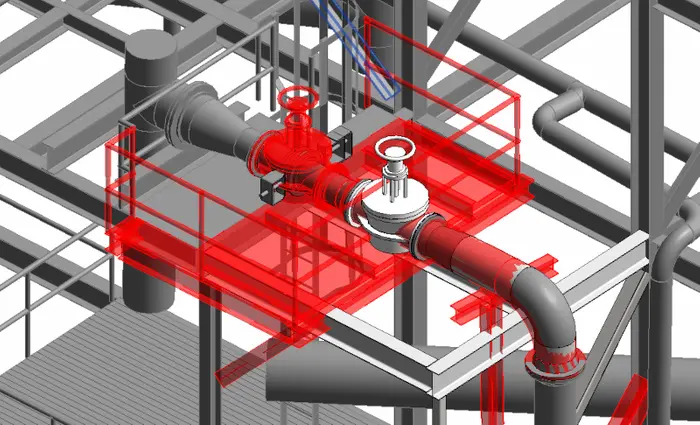
Using 3D Laser Scanning for Advanced Engineering Analysis
Laser scan technology allows professionals to complete advanced analysis and off-site visualization to plan for upcoming work. It can be used to tackle extremely technical engineering challenges.
3D laser scanning removes human error from the data collection process and provides quantitative and definitive measurement data. The exact dimensions and locations of complex project details can be recorded with 2–4-millimeter accuracy. The millions of data points gathered from 3D laser scanning can be used to create information-rich deliverables for advanced analysis. Clients have requested dimensional comparisons, floor surface contours, bolt hole locations, and precise measurements for prefabrication, to name a few.
Data can be assessed on a computer in a 3D space, allowing clients to get a real view of the site without actually having to physically be there. Data is accurate, measurable, sharable, and editable. Custom deliverables, such as 2D CAD drawings and 3D BIM models can be created to bring clarity and resolution to projects.
Special Applications for 3D Laser Scanning
Some 3D laser scanning projects require special applications due to limitations within the physical setting. Often times this is due to line-of-sight issues, when scanning must be done safely from the ground, or scanning at a precautionary distance. Some examples of these applications would include above-ceiling MEP features in hospitals where it is necessary to maintain negative airflow, interstitial spaces that are highly congested, spiral staircases, equipment in operation or elevator shafts with limited access. Existing Conditions has 3D laser scanned statues and monuments to create 3D mesh models in STL or OBJ format. Since laser scanning is a non-contact measurement tool (we can scan from a safe distance and location) this becomes a powerful tool for solving these complex challenges.
Existing Conditions 3D Laser Scanning Services
Over the past 27 years, we have measured, documented, and modeled over 10,000 buildings spanning over 700 million square feet across the United States, establishing ourselves as an industry leader in 3D laser scanning. Architects, builders, engineers, developers, and facility managers, trust us to deliver digital representations of the as-built environment with unparalleled accuracy and efficiency. Our dedicated Project Managers provide fast and accurate 3D laser scanning services and drone imagery services, and expert CAD and BIM technicians create custom, detailed deliverables. Our greatest reward remains delivering superior-quality scan-to-BIM work and knowing we played a vital role in our clients’ unique and historic projects.
Contact us today for a free project estimate.
How Existing Conditions Ensures Privacy for Your Projects
At Existing Conditions, we are not only pioneers in creating precise digital versions of the built environment but are also deeply committed to respecting the privacy of individuals residing or working in the spaces we survey. Our approach to privacy is grounded in both our professional ethics and our understanding of the vital importance of personal space and information.
Here's how we ensure that privacy is upheld:
- Advanced Notice: Before any scanning project begins, occupants of the building are typically given advanced notice. This allows them to be informed about our processes and to prepare or remove any personal items if they choose.
- No Personal Data Collection: Our reality capture tools, including laser scanning and drone imaging, are operated specifically to capture relevant architectural details and not personal or identifiable information. Any inadvertent capture of personal items is discarded or edited out of the project deliverables.
- Trained Professionals: Our team is trained to be respectful and discreet. They understand the importance of privacy and are instructed to avoid capturing areas that might compromise an individual's personal information.
- Secure Data Handling: All captured data is stored securely, with stringent protocols in place to prevent unauthorized access. We utilize industry-leading encryption and cybersecurity measures to ensure that the data remains confidential.
- Transparency: We maintain open communication with property owners, managers, and occupants. If there are any concerns or questions about our processes or the data we capture, we are always available to address them.
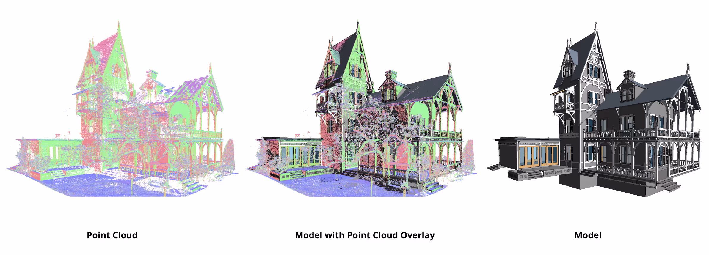
Existing Conditions is proud to set industry standards not just in the quality of our 3D laser scanning surveys, but also in our commitment to privacy and respect. Trust is the foundation of our partnerships, and we strive every day to earn and maintain that trust.
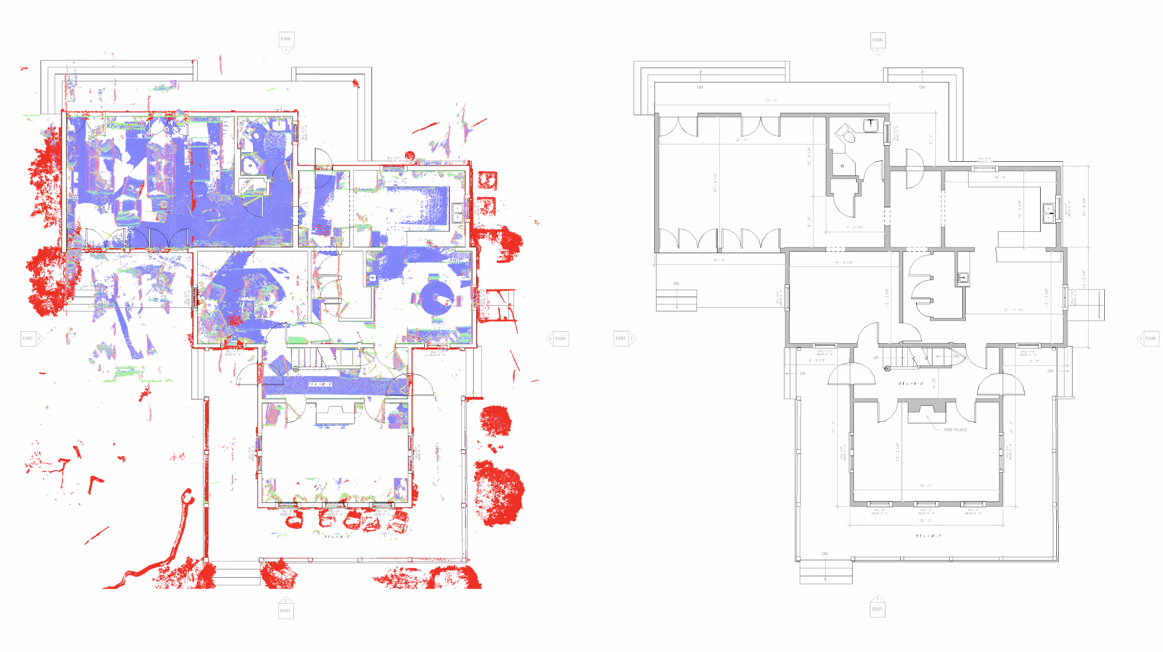
Existing Conditions 3D Laser Scanning Services
Over the past 27 years, we have measured, documented, and modeled over 10,000 buildings spanning over 700 million square feet across the United States, establishing ourselves as an industry leader in 3D laser scanning. Architects, builders, engineers, developers, and facility managers, trust us to deliver digital representations of the as-built environment with unparalleled accuracy and efficiency. Our dedicated Project Managers provide fast and accurate 3D laser scanning services and drone imagery services, and expert CAD and BIM technicians create custom, detailed deliverables. Our greatest reward remains delivering superior-quality scan-to-BIM work and knowing we played a vital role in our clients’ unique and historic projects.
How Existing Conditions Ensures the Security of Your Digital Content
The download link provided allows access to anyone who has the link. Forward this link to anyone who needs access to download the files.
If you would prefer additional security for your files, contact IT@existingconditions.com. This will allow you to restrict access to the shared content on our servers. Please provide us with the email addresses you would like to grant access to for uploading and downloading files.
All work shall be field verified by the client prior to design, construction, or other uses. Contact Existing Conditions if any updates are needed that fall within our scope of work.
We're here to help.
Downloading digital content from our Google servers or accessing files attached to our emails acknowledges our terms and conditions for file content.
Existing Conditions 3D Laser Scanning Services
Over the past 27 years, we have measured, documented, and modeled over 10,000 buildings spanning over 700 million square feet across the United States, establishing ourselves as an industry leader in 3D laser scanning. Architects, builders, engineers, developers, facility managers, trust us to deliver digital representations of the as-built environment with unparalleled accuracy and efficiency. Our dedicated Project Managers provide fast and accurate 3D laser scanning services and drone imagery services, and expert CAD and BIM technicians create custom, detailed deliverables. Our greatest reward remains delivering superior-quality scan-to-BIM work and knowing we played a vital role in our clients’ unique and historic projects.
Contact us today for a free project estimate.
How Existing Conditions Helps Ensure the Long-Term Success of your Projects
At Existing Conditions, we view our work with you as a collaboration. We do not have customers – we have clients. That means we do not look for one-time transactions. Instead, we look to grow a long-standing relationship with each individual client, ensuring that your success is our success. We are here to help in any way we can throughout the course of the project, and the next one. Our goal is to become your go-to source for creating accurate existing conditions documentation.
Because the 3D laser scanner captures everything within line of sight in a full 360 degrees, we have a lot of additional information captured within the 3D point cloud than the scope of work calls for. This allows us to provide additional modeling services without the need for us to return to the site. If, down the road for example, you need reflected ceiling plans in addition to the floor plans we already documented for you, we can pull up that scan data for your building and create those RCPs for you with no re-mobilization fees.
The best time to capture a building is after all of the demolition is complete, but because of occupancy and timelines, many times you need reliable data before demolition can begin. We can scan the building in its current condition, get as much information as we can, and deliver that data to you. Then, when the demolition is complete and items that were previously obscured are revealed, we can return to site and tie that information directly back into the previously captured data. This way you can quickly verify any assumptions that had to be made due to the timeline, before construction begins.
Existing Conditions 3D Laser Scanning Services
Over the past 27 years, we have measured, documented, and modeled over 10,000 buildings spanning over 700 million square feet across the United States, establishing ourselves as an industry leader in 3D laser scanning. Architects, builders, engineers, developers, and facility managers, trust us to deliver digital representations of the as-built environment with unparalleled accuracy and efficiency. Our dedicated Project Managers provide fast and accurate 3D laser scanning services and drone imagery services, and expert CAD and BIM technicians create custom, detailed deliverables. Our greatest reward remains delivering superior-quality scan-to-BIM work and knowing we played a vital role in our clients’ unique and historic projects.
Contact us today for a free project estimate.
How Existing Conditions Integrates Point Cloud Data Into AutoCAD
While AutoCAD is a powerful tool for 2D drafting and 3D modeling, integrating point clouds into this software can pose challenges. AutoCAD's native support for point clouds is limited compared to specialized point cloud processing software. Here's how we optimize the workflow for clients who prefer to use AutoCAD:
Recognizing AutoCAD's Strengths: AutoCAD excels in 2D drafting and is a valuable tool for many aspects of design and documentation. However, its native handling of point clouds can be cumbersome.
Overcoming Limitations: To make point cloud data more manageable in AutoCAD, we employ a workaround. We create PDFs in Revit that contain the necessary views and details extracted from the point cloud data. These PDFs serve as reference files that can be imported into AutoCAD.
Streamlining the Process: This approach simplifies the use of point clouds within AutoCAD. Instead of dealing with the complexities of manipulating point cloud data directly in AutoCAD, users can work with the PDF reference files, which offer a more user-friendly experience.
Enhancing Efficiency: By providing clients with well-organized PDFs that encapsulate the required views and details, we ensure that their AutoCAD workflows remain efficient. This method reduces the need for extensive manipulation of point cloud data within AutoCAD, making it easier to produce accurate drawings and models.
While AutoCAD may not be the optimal tool for direct point cloud manipulation, our approach leverages the strengths of both Revit and AutoCAD to create a seamless workflow. This ensures that our clients can efficiently incorporate point cloud data into their projects while capitalizing on the capabilities of these software applications.
If you'd like to learn more, visit our portfolio, or contact us to connect with a member of our team.
How to Decide if You Should Purchase 3D Laser Scanning Equipment
The decision to invest in a LiDAR system for your firm is a significant one, and it's crucial to weigh the associated costs against the potential benefits. While LiDAR technology offers numerous advantages, it's important to understand the true financial implications of such a purchase. Almost any project that requires as-built information can benefit from a 3D laser scanning survey. This may have you asking yourself whether or not you should purchase the equipment for your own firm.
First, it's important to understand the true costs of purchasing your own architectural-grade 3D laser scanning equipment and the savings associated with hiring a qualified professional.
Beyond the initial investment in the equipment, there are several other costs to consider when contemplating the purchase of a LiDAR system:
- Qualified Personnel: Operating a LiDAR system requires skilled personnel who are trained in its use and maintenance.
- Software: Specialized software is essential for processing and analyzing the data collected by the LiDAR system.
- Training: Proper training for your team to effectively utilize the LiDAR equipment is necessary.
- Scanner Calibration: Regular calibration and maintenance are essential to ensure the accuracy and reliability of the LiDAR system.
- Legal Fees: Compliance with regulations and legal requirements may involve additional costs.
It's essential to recognize that while owning a LiDAR system can offer long-term benefits, the initial and ongoing expenses can be substantial. Many firms find that it is more cost-effective to contract out their 3D laser scanning and Building Information Modeling (BIM) needs to qualified professionals who possess the expertise, equipment, and resources to deliver accurate and reliable results.
By partnering with experienced professionals, you can leverage their specialized knowledge and equipment while avoiding the significant financial outlay associated with purchasing and maintaining your LiDAR system. To explore your options and estimate project costs, we encourage you to learn more about the benefits of outsourcing your 3D laser scanning and BIM requirements to experts in the field.
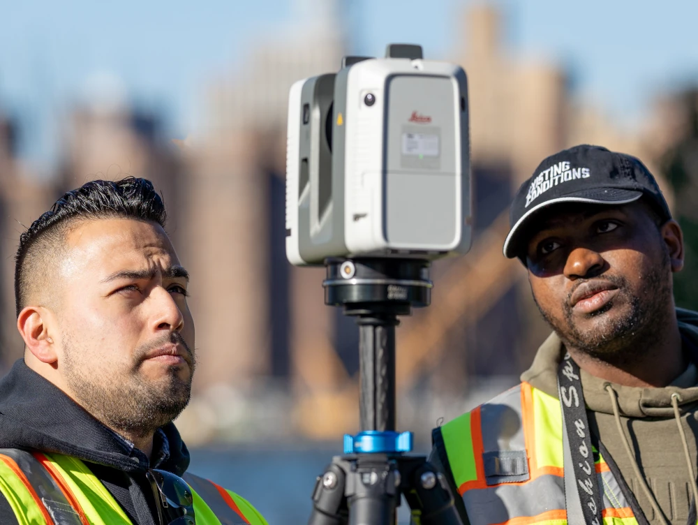
Existing Conditions 3D Laser Scanning Services
Over the past 27 years, we have measured, documented, and modeled over 10,000 buildings spanning over 700 million square feet across the United States, establishing ourselves as an industry leader in 3D laser scanning. Architects, builders, engineers, developers, and facility managers, trust us to deliver digital representations of the as-built environment with unparalleled accuracy and efficiency. Our dedicated Project Managers provide fast and accurate 3D laser scanning services and drone imagery services, and expert CAD and BIM technicians create custom, detailed deliverables. Our greatest reward remains delivering superior-quality scan-to-BIM work and knowing we played a vital role in our clients’ unique and historic projects.
How to Share Digital Content with Existing Conditions
If you would like to upload files to our servers, you will need a Google account or Gmail address. Please provide us with the Google email addresses you would like to grant access for uploading files.
If you do not have a Google account, then you are welcome to sign up for one, or send us a download link to your preferred cloud service such as Box, Dropbox, or WeTransfer.
Existing Conditions 3D Laser Scanning Services
Over the past 27 years, we have measured, documented, and modeled over 10,000 buildings spanning over 700 million square feet across the United States, establishing ourselves as an industry leader in 3D laser scanning. Architects, builders, engineers, developers, and facility managers, trust us to deliver digital representations of the as-built environment with unparalleled accuracy and efficiency. Our dedicated Project Managers provide fast and accurate 3D laser scanning services and drone imagery services, and expert CAD and BIM technicians create custom, detailed deliverables. Our greatest reward remains delivering superior-quality scan-to-BIM work and knowing we played a vital role in our clients’ unique and historic projects.
Industrial Property 3D Laser Scanning Services
Our team possesses extensive expertise in delivering precise 3D laser scanning services for industrial structures. Over the course of decades, we've had the privilege to contribute to some of the most notable and high-profile industrial projects across the United States. This experience equips us with a deep understanding of the unique demands and intricacies associated with industrial building documentation.
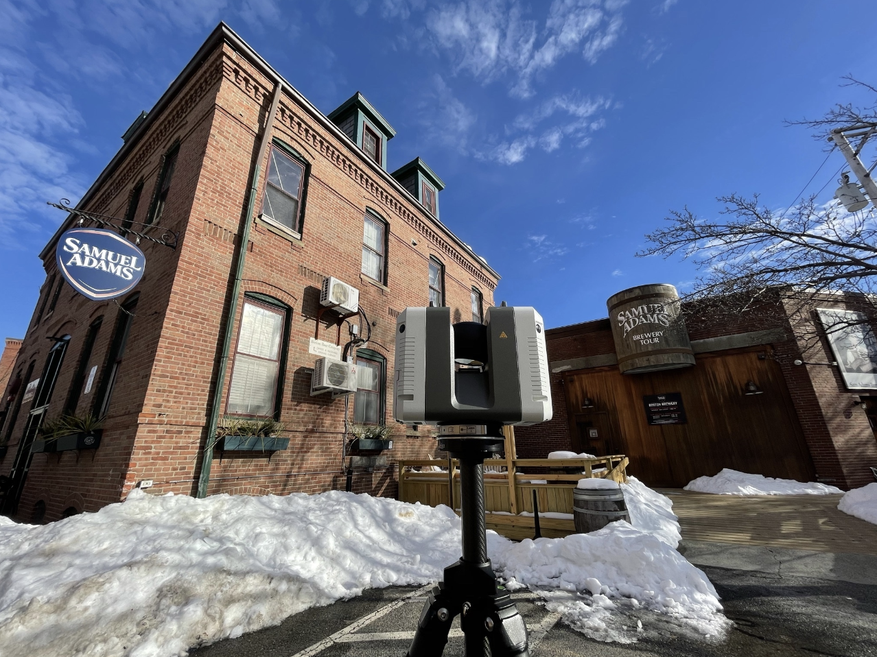
Industrial facilities encompass a wide range of complex structures, each presenting its own set of challenges and requirements. Our seasoned professionals are well-versed in addressing these challenges, whether it involves documenting historic industrial sites or facilitating documentation for modern industrial projects.
Accuracy and attention to detail are paramount in the industrial sector, where precision can impact operational efficiency, safety, and compliance. By entrusting us with your industrial building documentation needs, you gain access to a wealth of knowledge and a proven track record of delivering exceptional results.
Our commitment to excellence ensures that your industrial project receives the meticulous attention it deserves, and we pride ourselves on consistently delivering work of the highest quality. When it comes to documenting industrial buildings, trust in our decades of experience and expertise to get the job done right.
Industrial Experience and Expertise
Our team has decades of experience when it comes to delivering 3D laser scanning services for industrial buildings. We've had the privilege to work on some of the most valuable and high pro le industrial projects in the United States, and we know what's required to get the job done right. Below is a selection of relevant projects we have measured and modeled in recent years.
1. The American Locomotive Works, Providence, Rhode Island, measured over 900,000 sq. ft.
2. The Eagle Mill, Lee, Massachusetts, modeled over 400,000 sq. ft. of industrial space
3. 250 Canal Street, Lawrence, Massachusetts. model of the entire 450,000 sq. ft. mill
4. The Paragon Worsted Mill, Providence, Rhode Island, measured over 300,000 sq. ft. of space
5. 26 Jackson Street, Lowell, Massachusetts, modeled approximately 250,000 sq. ft.
6. The LaGrange Mill Complex, Worcester, Massachusetts, measured over 400,000 sq. ft.
7. The Star Mill, Middleborough, Massachusetts, modeled more than 350,000 sq. ft.
8. The Winchester Gun Factory, New Haven, Connecticut, approximately 850,000 sq. ft.
9. The Locke Street Mill, Haverhill, Massachusetts, measured roughly 275,000 sq. ft.
Existing Conditions 3D Laser Scanning Services
Over the past 27 years, we have measured, documented, and modeled over 10,000 buildings spanning over 700 million square feet across the United States, establishing ourselves as an industry leader in 3D laser scanning. Architects, builders, engineers, developers, facility managers, trust us to deliver digital representations of the as-built environment with unparalleled accuracy and efficiency. Our dedicated Project Managers provide fast and accurate 3D laser scanning services and drone imagery services, and expert CAD and BIM technicians create custom, detailed deliverables. Our greatest reward remains delivering superior-quality scan-to-BIM work and knowing we played a vital role in our clients’ unique and historic projects.
Lab Conversion 3D Laser Scanning Services
Our team boasts an extensive history spanning decades, specializing in the meticulous 3D laser scanning and as-built documentation of lab conversions. Over the years, we've been honored to contribute our expertise to some of the most renowned and historically significant lab conversion projects across the United States. This extensive experience has afforded us a deep understanding of the unique challenges and intricacies involved in repurposing laboratory spaces.
Lab conversions demand precision and attention to detail, as they often involve transforming cutting-edge research facilities into innovative new spaces. Our commitment to excellence goes beyond architectural aspects, encompassing the intricate network of mechanical, electrical, and plumbing systems that underpin these conversions.
We recognize that lab conversions are not merely about aesthetics but about preserving the scientific legacy of these spaces while adapting them to new purposes. Whether it's converting a historic laboratory into a modern research hub or repurposing a scientific facility into a state-of-the-art educational institution, we possess the expertise required to ensure the job is done right.
Our team's dedication to accuracy, reliability, and adherence to the highest standards in lab conversion documentation is a testament to our commitment to preserving the rich history of these facilities while ushering them into a new era of productivity and innovation.
Existing Conditions 3D Laser Scanning Services
Over the past 27 years, we have measured, documented, and modeled over 10,000 buildings spanning over 700 million square feet across the United States, establishing ourselves as an industry leader in 3D laser scanning. Architects, builders, engineers, developers, and facility managers, trust us to deliver digital representations of the as-built environment with unparalleled accuracy and efficiency. Our dedicated Project Managers provide fast and accurate 3D laser scanning services and drone imagery services, and expert CAD and BIM technicians create custom, detailed deliverables. Our greatest reward remains delivering superior-quality scan-to-BIM work and knowing we played a vital role in our clients’ unique and historic projects.
Laboratory 3D Laser Scanning Services
Laboratory spaces are distinct in their intricate requirements, demanding meticulous attention to detail in design and construction. Our team comprehends the unique intricacies of laboratory facilities, from specialized equipment installations to stringent safety protocols and rigorous adherence to scientific standards.
We understand that laboratory as-built documentation is not merely a matter of recording spatial dimensions but a critical element in ensuring the functionality, safety, and regulatory compliance of these highly specialized environments. Our extensive 3D laser scanning experience enables us to capture the nuances of laboratory layouts, equipment placements, and infrastructure with utmost precision.
Whether it's a historic laboratory facility undergoing renovation or a cutting-edge research center pushing the boundaries of scientific discovery, our team leverages its wealth of experience to ensure that every aspect is documented accurately. This documentation aids in the planning, construction, operation, and validation of laboratory spaces, contributing to the success of projects that advance scientific research and innovation in the United States.
Laboratory Experience and Expertise
Our team has decades of experience when it comes to delivering accurate building documentation for laboratory buildings. We've had the privilege to work on some of the most challenging and high-profile lab projects in the United States, and we know what's required to get the job done right. Below is a selection of relevant projects we have measured and modeled in recent years.
1. The Howard Hughes Medical Institute, Chevy Chase, Maryland
2. Tufts University Medical Center, Boston, Massachusetts
3. Wellesley College Science Center Building, Wellesley, Massachusetts
4. Ginko Bioworks, 27 Drydock Avenue Boston, Massachusetts
5. New York University Langone Medical Research Center, New York, New York
6. Genzyme Pharmaceuticals, Cambridge, Massachusetts
7. Sano Pharmaceuticals, Cambridge, Massachusetts
8. Stanford University Science Center, Stanford, California
9. United States Department of Agriculture Research Laboratory, Boston, Massachusetts
10. Tufts University School of Veterinary Research, Grafton, Massachusetts
Existing Conditions 3D Laser Scanning Services
Over the past 27 years, we have measured, documented, and modeled over 10,000 buildings spanning over 700 million square feet across the United States, establishing ourselves as an industry leader in 3D laser scanning. Architects, builders, engineers, developers, facility managers, trust us to deliver digital representations of the as-built environment with unparalleled accuracy and efficiency. Our dedicated Project Managers provide fast and accurate 3D laser scanning services and drone imagery services, and expert CAD and BIM technicians create custom, detailed deliverables. Our greatest reward remains delivering superior-quality scan-to-BIM work and knowing we played a vital role in our clients’ unique and historic projects.
Leasing Analysis with 3D Laser Scanning Services
With a wealth of experience spanning several decades, our team specializes in providing precise building documentation tailored for leasing purposes. Throughout our journey, we have been entrusted to 3D laser scan some of the most intricate and multifaceted leasing-related projects in the United States, which have honed our expertise and refined our capabilities.
Leasing projects are inherently dynamic and require meticulous as-built documentation to facilitate smooth transactions and agreements between lessors and lessees. Our team's deep-rooted experience enables us to navigate the complexities of leasing with unmatched precision and insight.
We recognize that each leasing project is unique, with its specific requirements and nuances. Our extensive 3D laser scanning experience equips us with the knowledge to adapt to diverse leasing scenarios, whether it involves commercial properties, residential complexes, or mixed-use developments. Our as-built documentation is tailored to capture every essential detail, ensuring that both lessors and lessees have a comprehensive understanding of the property's condition, layout, and any specific terms and conditions.
Our commitment to accuracy and attention to detail is paramount, as we understand that leasing agreements hinge on transparency and clarity. We take pride in our role as trusted as-built documentation providers, facilitating seamless leasing processes and fostering successful partnerships between property owners and tenants.
Whether it's helping commercial entities find their ideal office space or assisting individuals in securing their dream home, our team is dedicated to delivering 3D laser scanning services and 3D BIM modeling services that streamline the leasing experience. Our work not only facilitates informed decision-making but also contributes to the overall success and satisfaction of our clients in the world of leasing.
Existing Conditions 3D Laser Scanning Services
Over the past 27 years, we have measured, documented, and modeled over 10,000 buildings spanning over 700 million square feet across the United States, establishing ourselves as an industry leader in 3D laser scanning. Architects, builders, engineers, developers, and facility managers, trust us to deliver digital representations of the as-built environment with unparalleled accuracy and efficiency. Our dedicated Project Managers provide fast and accurate 3D laser scanning services and drone imagery services, and expert CAD and BIM technicians create custom, detailed deliverables. Our greatest reward remains delivering superior-quality scan-to-BIM work and knowing we played a vital role in our clients’ unique and historic projects.
Contact us today for a free project estimate.
MEP/FP System 3D Laser Scanning Services
With decades of 3D laser scanning experience, our team excels in providing accurate documentation for Mechanical, Electrical, Plumbing, and Fire Protection (MEP/FP) applications. We've had the privilege to contribute to some of the most demanding MEP projects in the industry, demonstrating our commitment to delivering high-quality results.
Whether it's a complex industrial facility, a high-rise commercial building, or a residential project, our team is well-equipped to deliver MEP/FP as-built documentation that adheres to industry best practices and client expectations. We take pride in our ability to provide comprehensive, reliable, and precise documentation that ensures the successful implementation of MEP/FP systems in diverse construction projects.
Our 3D laser scanning expertise in MEP/FP documentation encompasses various critical aspects. Request a quote for MEP documentation services today.
Precision in Design:
We understand the intricate nature of MEP systems and the essential role they play in building functionality. Our meticulous documentation ensures that every detail is accurately documented, from HVAC systems to electrical layouts, plumbing networks, and fire protection measures.
Complex Project Challenges:
Over the years, we've tackled MEP projects that present unique challenges and complexities. Our experience equips us to navigate these intricacies efficiently, providing clients with 3D laser scanning solutions that meet their specific requirements.
Regulatory Compliance:
Compliance with building codes and regulations is paramount in MEP/FP design. Our documentation not only meets these standards but also offers a clear roadmap for regulatory compliance throughout the project lifecycle.
Seamless Integration:
Effective coordination and integration of MEP/FP systems are vital for optimal building performance. Our as-built documentation services ensures that these systems work cohesively, minimizing conflicts and maximizing efficiency.
Efficiency and Cost Savings:
Accurate MEP/FP documentation contributes to project efficiency and cost savings. It enables precise planning, reduces the risk of errors and rework, and ultimately leads to smoother project execution.
Safety and Sustainability:
We prioritize safety and sustainability in our MEP/FP documentation. This includes fire protection measures and environmentally friendly practices that align with modern building standards.
.webp)
MEP/FP Experience and Expertise
Our team has decades of experience when it comes to delivering accurate building documentation for mechanical runs within buildings. We know what's required to get the job done right. Below is a selection of relevant projects we have measured and modeled in recent years.
1. Wellesley Science Center and Mechanical Tunnels, Wellesley, MA
2. Energy / Resource Recovery Facility, Fairfax, VA
3. Covanta Semass, West Wareham, MA
4. Wheelabrator, Bridgeport, CT
5. Kens Food, Southboro, MA
6. Sudbury Aqueduct, Sudbury, MA
7. WIBR Mechanical Penthouse, Boston, MA
8. Alewife MBTA Station, Cambridge, MA
9. Seaport Bridge, Boston, MA
10. CIH – Tower 1 at South Station, Boston, MA
Request a quote for MEP documentation services today.
.png)
Existing Conditions 3D Laser Scanning Services
Over the past 27 years, we have measured, documented, and modeled over 10,000 buildings spanning over 700 million square feet across the United States, establishing ourselves as an industry leader in 3D laser scanning. Architects, builders, engineers, developers, facility managers, trust us to deliver digital representations of the as-built environment with unparalleled accuracy and efficiency. Our dedicated Project Managers provide fast and accurate 3D laser scanning services and drone imagery services, and expert CAD and BIM technicians create custom, detailed deliverables. Our greatest reward remains delivering superior-quality scan-to-BIM work and knowing we played a vital role in our clients’ unique and historic projects.
Mixed Use Development 3D Laser Scanning Services
With a wealth of experience spanning decades, our team specializes in providing precise 3D laser scanning services and building documentation for mixed-use buildings. Our extensive portfolio includes collaborations on some of the most iconic and historically significant mixed-use projects across the United States. This vast experience has honed our 3D laser scanning expertise and equipped us with the knowledge necessary to excel in this demanding field.
Mixed-use buildings are unique in their multifaceted nature, combining residential, commercial, and often cultural or recreational spaces within a single structure. Our team understands the intricacies of harmonizing these diverse elements into a cohesive whole. We recognize that such projects require not only technical precision but also a keen understanding of the architectural, functional, and regulatory complexities inherent in mixed-use developments.
Our commitment to excellence in 3D laser scanning means we are well-versed in capturing every detail of these multifunctional spaces, from residential units to retail areas, offices, and communal spaces. Our as-built documentation serves as a comprehensive record, aiding in design, construction, maintenance, and historical preservation.
Existing Conditions' Project Managers use industry-leading Leica survey-grade laser scanners to capture accurate existing site conditions in the form of a point cloud. Our in-house Mapping & Modeling Team can transform those point clouds into customized 2D CAD drawings, 3D BIM models, 3D mesh models, TruViews, and 3D virtual tours at any level of detail for visualization, analysis, design, construction, and renovation.
Whether it's a historic mixed-use landmark undergoing renovation or a cutting-edge development pushing the boundaries of design, we bring our 3D laser scanning experience and dedication to ensure that every project is documented accurately, facilitating informed decision-making and contributing to the success of mixed-use buildings that define urban landscapes across the nation.
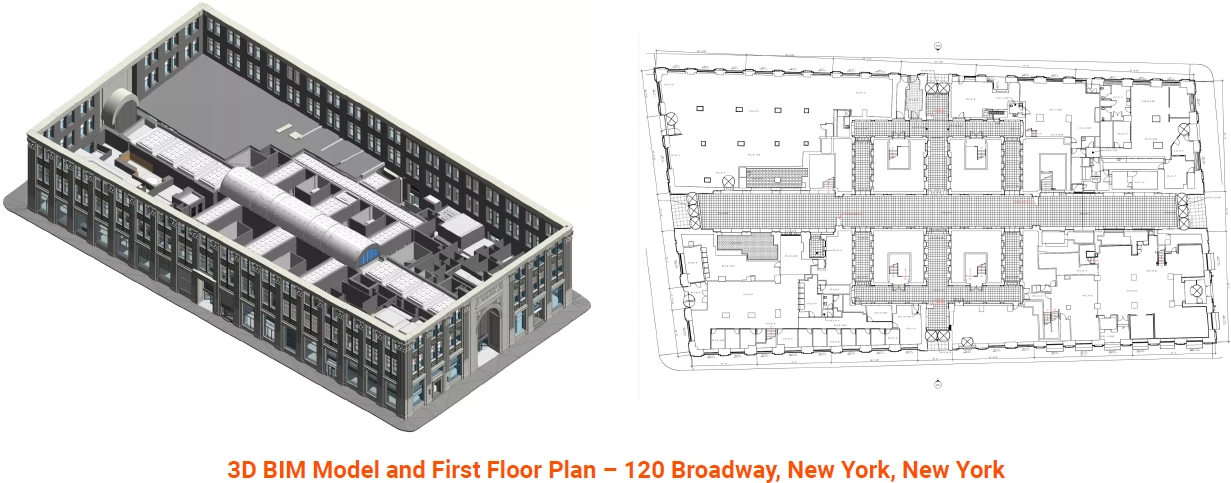
Mixed Use 3D Laser Scanning Experience and Expertise
Our team has decades of experience when it comes to delivering accurate building documentation for mixed-use developments. We've had the privilege to work on some of the most historic and high-profile mixed-use projects in the United States, and we know what's required to get the job done right. Below is a selection of relevant projects we have measured and modeled in recent years.
- 1 Broadway, Cambridge, Massachusetts
- 120 Broadway, New York, New York
- 50 Congress Street, Boston, Massachusetts
- 1 Kendall Square, Cambridge, Massachusetts
- 1 Post Office Square, Boston, Massachusetts
- 10 Post Office Square, Boston, Massachusetts
- 1 Liberty Square, Boston, Massachusetts
- Russia Wharf, Atlantic Avenue, Boston, Massachusetts
- 820 South Michigan Avenue, Chicago, Illinois
- 1200 Avenue of the Americas, New York, New York
Existing Conditions 3D Laser Scanning Services
Over the past 27 years, we have measured, documented, and modeled over 10,000 buildings spanning over 700 million square feet across the United States, establishing ourselves as an industry leader in 3D laser scanning. Architects, builders, engineers, developers, facility managers, trust us to deliver digital representations of the as-built environment with unparalleled accuracy and efficiency. Our dedicated Project Managers provide fast and accurate 3D laser scanning services and drone imagery services, and expert CAD and BIM technicians create custom, detailed deliverables. Our greatest reward remains delivering superior-quality scan-to-BIM work and knowing we played a vital role in our clients’ unique and historic projects.
Mobile Devices & Point Cloud Data
Mobile Devices & Point Cloud Data
There are many web hosted services that can be used to publish point cloud data for mobile devices, but these usually have a monthly or yearly subscription as well as a fee per amount of data stored. Examples of these services can be found here for Faro scans and Leica Scans (you must register to view Leica TruView Cloud data).
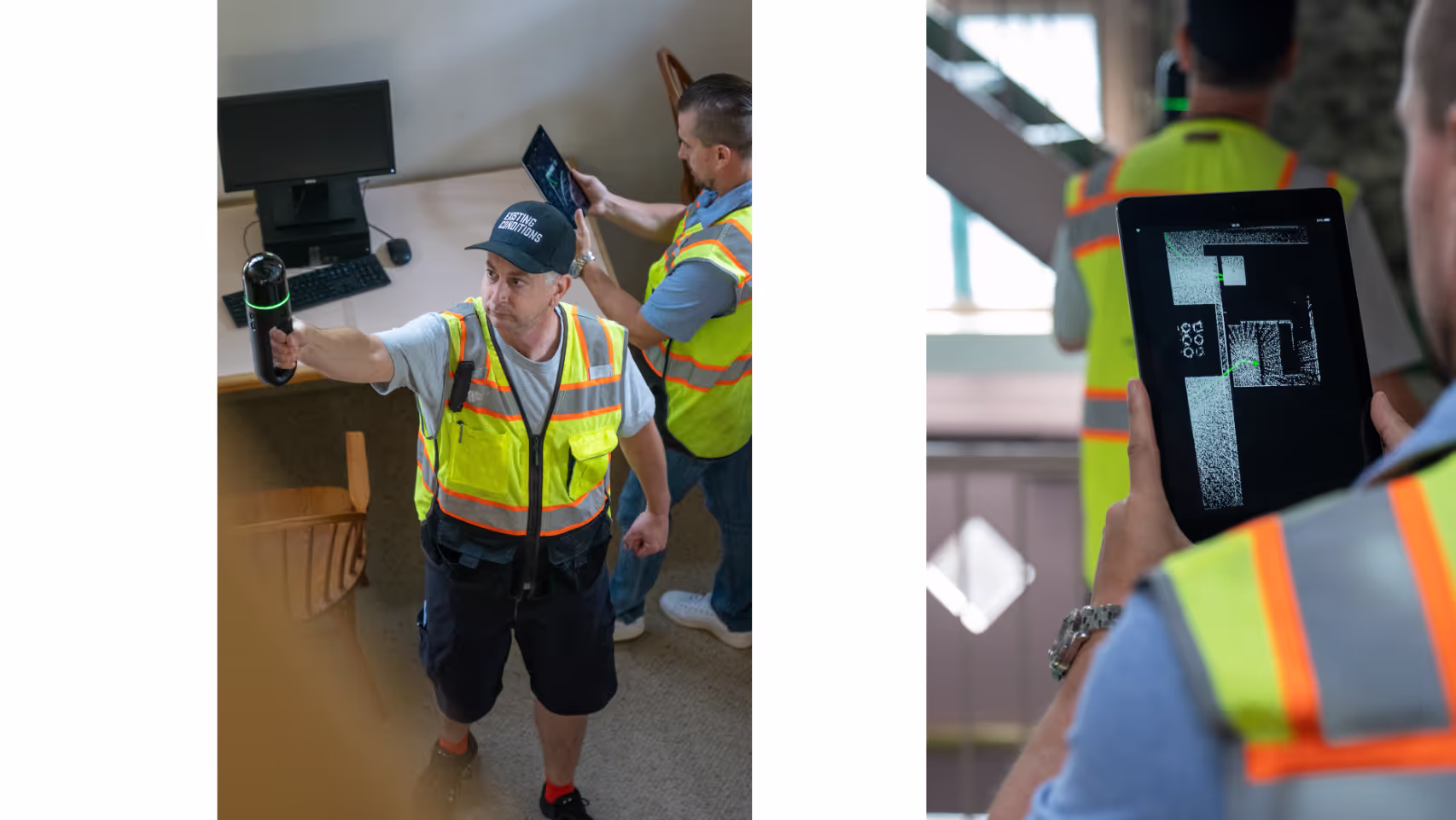
Free viewing tools for point cloud data are currently incompatible with mobile devices or Mac OS. These software will only run on a Windows machine.
For enterprise level users, there are hosted server applications that can be purchased and hosted in-house. This is a better solution for large institutions that want to make their data accessible to users on mobile and Mac OS platforms. This is available for Leica scans.
It is possible to view point cloud data on a mobile device if a Remote Desktop application is used on the mobile device to access a Windows PC which is running the software. Chrome Remote Desktop is an application that is free and easy to use for accessing your desktop while in the field. This option will only allow one person to access the data on one machine at a time.
If you'd like to learn more, visit our portfolio, or contact us to connect with a member of our team.
Multifamily Property 3D Laser Scanning Services
With a wealth of 3D laser scanning experience spanning decades, our team excels in delivering precise as-built documentation for multifamily buildings. Over the years, we've had the privilege of contributing to some of the most noteworthy and high-profile multifamily projects across the United States. Our extensive 3D laser scanning experience equips us with the knowledge and skills necessary to ensure that every project is executed to the highest standards.
Existing Conditions' Project Managers use industry-leading Leica survey-grade laser scanners to capture accurate existing site conditions in the form of a point cloud. Our in-house Mapping & Modeling Team can transform those point clouds into customized 2D CAD drawings, 3D BIM models, 3D mesh models, TruViews, and 3D virtual tours at any level of detail for visualization, analysis, design, construction, and renovation.
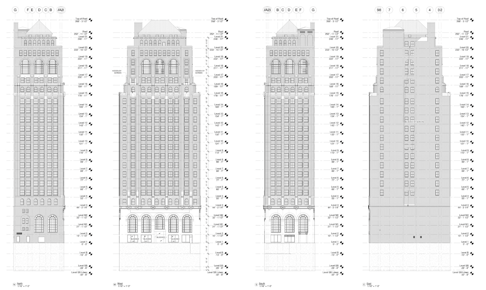
Whether it involves historic preservation, modern multifamily developments, or any other multifamily building endeavor, we understand the unique demands of this sector. Our commitment to 3D laser scanning excellence and accuracy drives us to deliver building documentation that exceeds expectations and fulfills the specific requirements of multifamily projects.
When you partner with us, you can trust in our ability to provide the comprehensive and precise documentation needed to make informed decisions, optimize project efficiency, and ensure the success of multifamily building ventures. We're dedicated to getting the job done right, no matter the complexity or scale of the project.
Multifamily 3D Laser Scanning Experience and Expertise
Our team has decades of experience when it comes to delivering accurate building documentation for multifamily buildings. We've had the privilege to work on some of the most valuable and high pro le multifamily projects in the United States, and we know what's required to get the job done right. Below is a selection of relevant projects we have measured and modeled in recent years.
1. Pines of Perinton, Fairport, New York
2. Castle Square, Boston, Massachusetts
3. The Archer Residences, Boston, Massachusetts
4. Arlington 360, Arlington, Massachusetts
5. Ashmont Transit-Oriented Development, Boston, Massachusetts
6. Avalon Hilltop, Saugus, Massachusetts
7. Battery Wharf, Boston, Massachusetts
8. Cordoba Court, Opa Locka, Florida
9. Quincy Commons, Quincy, Massachusetts
10. Brighton Marine Housing, Brighton, Massachusetts
Existing Conditions 3D Laser Scanning Services
Over the past 27 years, we have measured, documented, and modeled over 10,000 buildings spanning over 700 million square feet across the United States, establishing ourselves as an industry leader in 3D laser scanning. Architects, builders, engineers, developers, facility managers, trust us to deliver digital representations of the as-built environment with unparalleled accuracy and efficiency. Our dedicated Project Managers provide fast and accurate 3D laser scanning services and drone imagery services, and expert CAD and BIM technicians create custom, detailed deliverables. Our greatest reward remains delivering superior-quality scan-to-BIM work and knowing we played a vital role in our clients’ unique and historic projects.
Existing Conditions 2D CAD Drawing & 3D BIM Model Deliverables
Architectural Layouts: Floor plans, elevations, sections, and RCPs showing the current configuration of walls, doors, windows, and more to document a building’s layout.
Structural Details: Up to date information about load-bearing walls, beams, columns, and foundation systems to understand a building's structural integrity and constraints.
Building Dimensions: Accurate measurements of all spaces, including heights, widths, and depths to avoid discrepancies during design.
MEP Systems: Location and layout of HVAC systems, electrical wiring, plumbing, and fire protection systems for redesign or upgrades.
Material Specifications: Details on existing materials used in walls, floors, roofs, and finishes for construction or renovation planning.
Condition Assessments: Documentation of the building’s current condition, identifying issues such as cracks, leaks, or wear that may require attention.
Museum 3D Laser Scanning Services
With over 27 years of 3D laser scanning experience, our team excels in providing meticulous as-built building documentation for museums. We consider it an honor to have contributed our 3D laser scanning services to some of the most prestigious museum projects in the United States, and our expertise is rooted in the unique requirements of these cultural institutions.
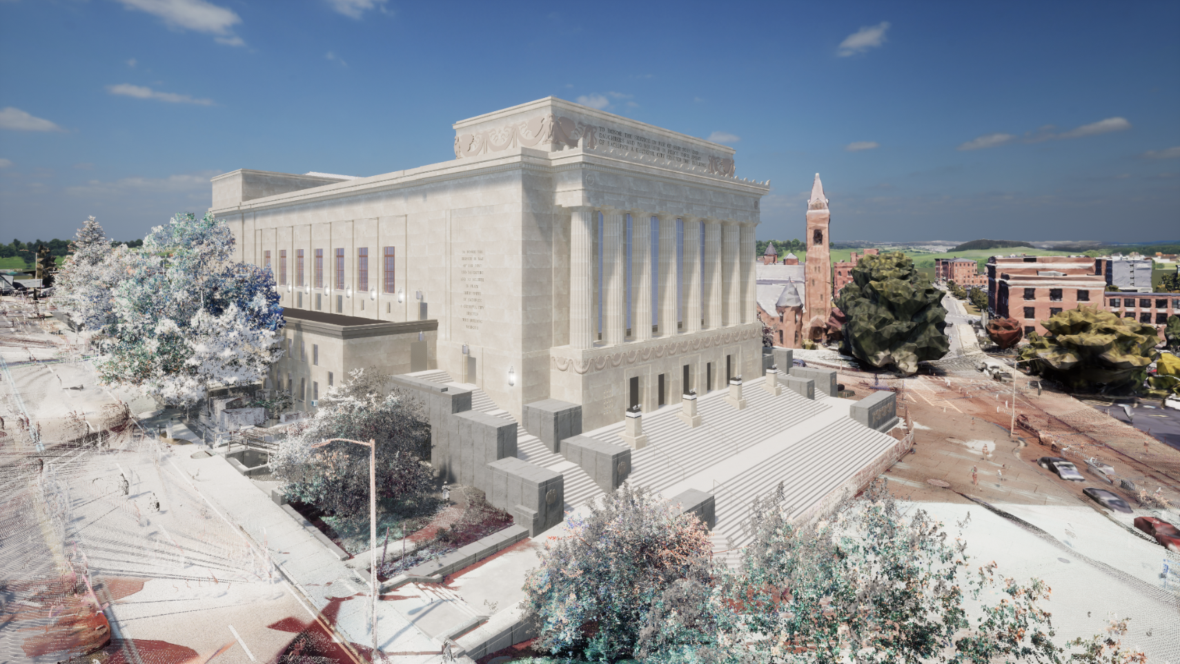
Preserving Art and History: Museums are the custodians of art, history, and culture. Our commitment to accuracy extends to ensuring that every detail of these institutions, from galleries to exhibition spaces, is documented with utmost precision to safeguard their invaluable treasures.
Curatorial Excellence: Our documentation takes into account the specialized needs of curators and conservators. We understand the importance of maintaining the environmental conditions necessary for preserving art and artifacts.
Visitor Experience: Museums aim to provide an enriching experience for visitors. Our documentation captures the layout and design of museum spaces to ensure that exhibits are accessible and engaging for all.
Historical Significance: Many museums are housed in historic buildings. We take pride in preserving the historical aspects of these structures while enhancing their suitability for modern museum functions.
Security and Conservation: Museums require robust security measures to protect their collections. Our documentation includes details related to security systems, ensuring the safety of invaluable artifacts.
Specialized Expertise: Our team includes specialists with extensive 3D laser scanning experience in documenting museum spaces. Their expertise ensures that every aspect of these institutions is accurately recorded.
Cultural Stewardship: We recognize the cultural importance of museums and approach our 3D laser scanning work with the utmost respect for the role these institutions play in society.
When it comes to precise building documentation for museums, our team's wealth of experience and unwavering commitment ensure that the job is executed to the highest standards. We take pride in contributing to the preservation and accessibility of art, history, and culture for the benefit of present and future generations.
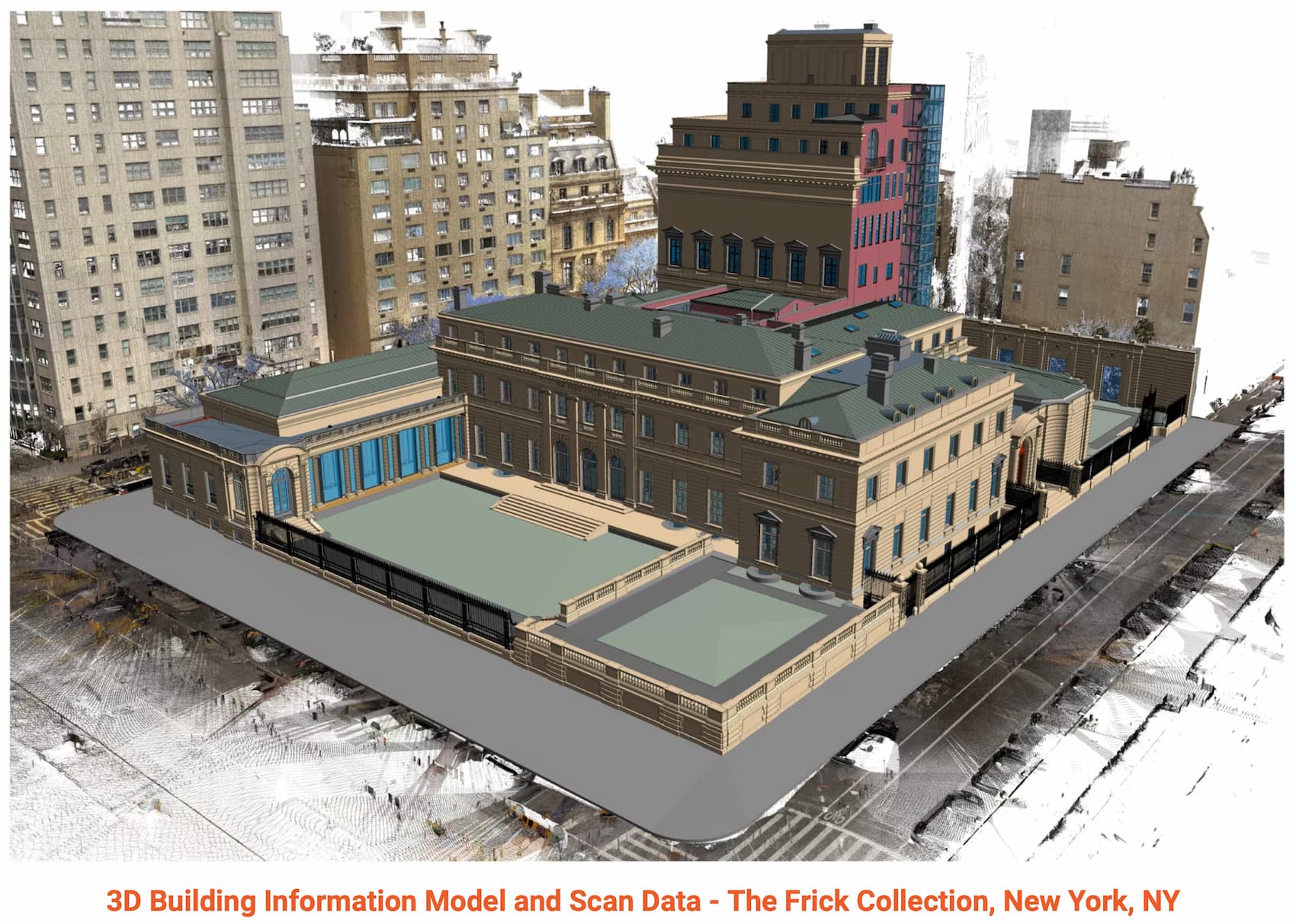
3D Laser Scanning Museum Experience and Expertise
Our team has decades of experience when it comes to delivering accurate building documentation for museum spaces. We've had the privilege to work on some of the most historic and high profile museums in the United States, and we know what's required to get the job done right. Below is a selection of relevant projects we have measured and modeled in recent years.
1. The Frick Collection, New York, New York
2. The Museum of Fine Arts, Boston, Massachusetts
3. The Intrepid Air and Space Museum, New York, New York
4. MASS MoCA, North Adams, Massachusetts
5. The Institute of Contemporary Art, Boston, MA
6. The New England Aquarium, Boston, Massachusetts
7. The Peabody Essex Museum, Salem, Massachusetts
8. The Norwalk Maritime Aquarium, Norwalk, Connecticut
9. The Whaling Museum, New Bedford, Massachusetts
10. The Museum of Science, Boston, Massachusetts
Existing Conditions 3D Laser Scanning Services
Over the past 27 years, we have measured, documented, and modeled over 10,000 buildings spanning over 700 million square feet across the United States, establishing ourselves as an industry leader in 3D laser scanning. Architects, builders, engineers, developers, facility managers, trust us to deliver digital representations of the as-built environment with unparalleled accuracy and efficiency. Our dedicated Project Managers provide fast and accurate 3D laser scanning services and drone imagery services, and expert CAD and BIM technicians create custom, detailed deliverables. Our greatest reward remains delivering superior-quality scan-to-BIM work and knowing we played a vital role in our clients’ unique and historic projects.
Office Building 3D Laser Scanning Services
Our team boasts decades of experience in providing precise 3D laser scanning services and building documentation for office spaces. We've had the privilege of contributing our expertise to some of the most historic and prestigious office projects across the United States. Our commitment to excellence ensures that we are well-equipped to handle the unique demands of documenting office spaces accurately and comprehensively.
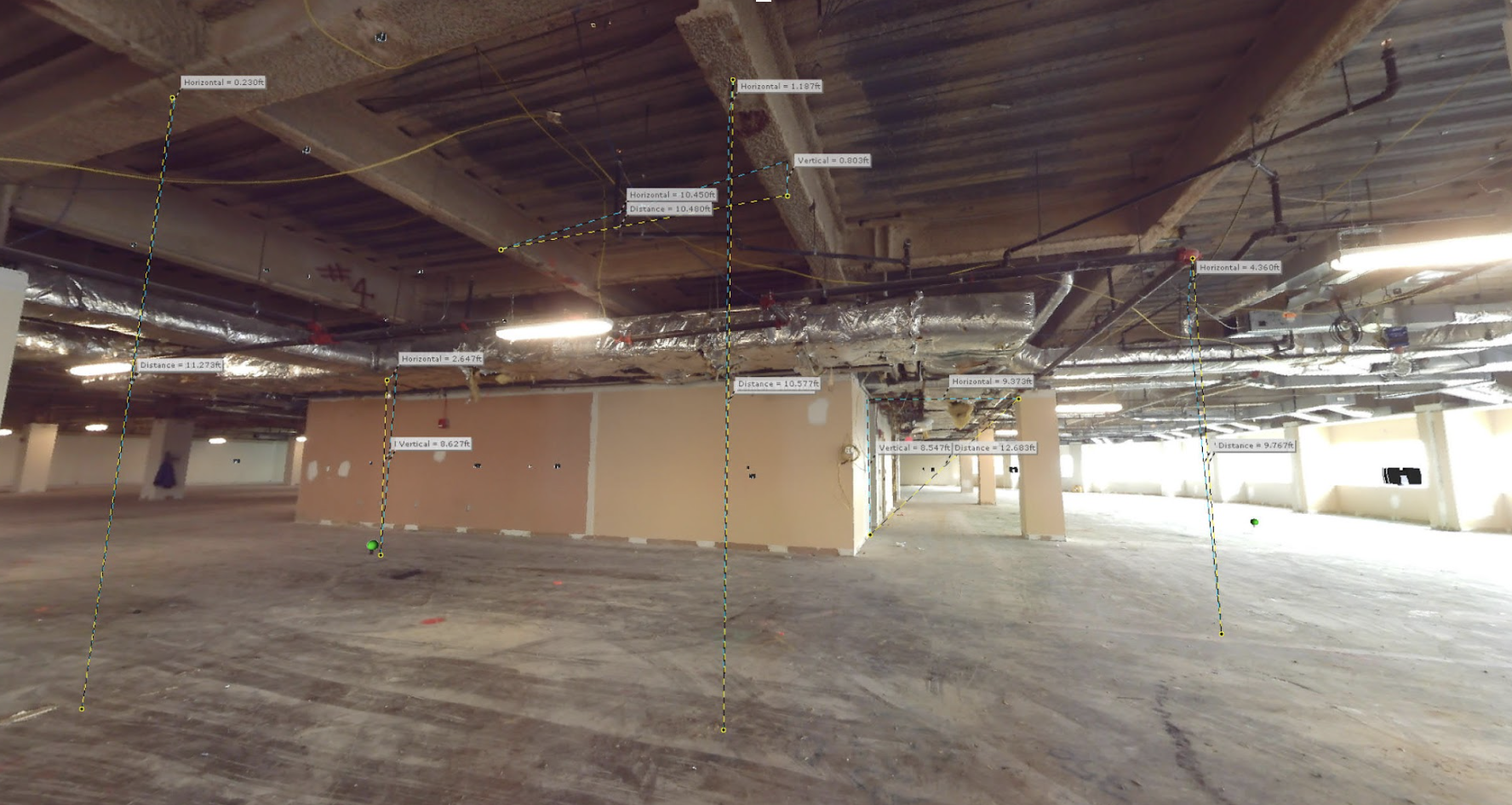
Whether it's a historic landmark or a contemporary office environment, we understand the intricacies involved in capturing the essence of office spaces. We recognize the importance of delivering work that meets the highest standards of quality, accuracy, and detail.
By entrusting us with your office space documentation needs, you gain access to a wealth of knowledge and a track record of success in this field. We are dedicated to ensuring that your project is executed with precision and efficiency, providing you with the valuable insights and data necessary for informed decision-making and project success.
Existing Conditions 3D Laser Scanning Office Experience and Expertise
Our team has decades of experience when it comes to delivering accurate building documentation for office buildings. We've had the privilege to work on some of the most historic and high-profile office projects in the United States, and we know what's required to get the job done right. Below is a selection of relevant projects we have measured and modeled in recent years.
- 1200 Avenue of the Americas, New York, New York
- 1 Broadway, Cambridge, Massachusetts
- 120 Broadway, New York, New York
- 50 Congress Street, Boston, Massachusetts
- 1 Kendall Square, Cambridge, Massachusetts
- 1 Post Office Square, Boston, Massachusetts
- 10 Post Office Square, Boston, Massachusetts
- 1 Liberty Square, Boston, Massachusetts
- Russia Wharf, Atlantic Avenue, Boston, Massachusetts
- 820 South Michigan Avenue, Chicago, Illinois
Existing Conditions 3D Laser Scanning Services
Over the past 27 years, we have measured, documented, and modeled over 10,000 buildings spanning over 700 million square feet across the United States, establishing ourselves as an industry leader in 3D laser scanning. Architects, builders, engineers, developers, and facility managers, trust us to deliver digital representations of the as-built environment with unparalleled accuracy and efficiency. Our dedicated Project Managers provide fast and accurate 3D laser scanning services and drone imagery services, and expert CAD and BIM technicians create custom, detailed deliverables. Our greatest reward remains delivering superior-quality scan-to-BIM work and knowing we played a vital role in our clients’ unique and historic projects.
Parking Structure 3D Laser Scanning Services
With decades of experience, our team excels in delivering precise as-built documentation for parking structures. We've provided 3D laser scanning services for many intricate parking projects across the United States, affording us invaluable insights into this specialized field. Parking structures demand meticulous planning, exact as-built documentation, and unwavering commitment to safety and functionality. From commercial parking garages to multi-level parking garages to underground parking garages, we capture every detail, ensuring structural integrity, safety, and compliance with regulations. We serve as trusted partners to architects, engineers, and contractors, offering the expertise needed for informed decisions, code adherence, and optimal facility functionality. Our legacy of experience in scan to BIM underscores our commitment to excellence in parking structure as-built documentation.
Existing Conditions 3D Laser Scanning Services
Over the past 27 years, we have measured, documented, and modeled over 10,000 buildings spanning over 700 million square feet across the United States, establishing ourselves as an industry leader in 3D laser scanning. Architects, builders, engineers, developers, and facility managers, trust us to deliver digital representations of the as-built environment with unparalleled accuracy and efficiency. Our dedicated Project Managers provide fast and accurate 3D laser scanning services and drone imagery services, and expert CAD and BIM technicians create custom, detailed deliverables. Our greatest reward remains delivering superior-quality scan-to-BIM work and knowing we played a vital role in our clients’ unique and historic projects.
Philadelphia 3D Laser Scanning Services
Delve into a comprehensive overview of the projects we've completed across the Philadelphia area. Our team has decades of experience when it comes to delivering accurate building documentation for buildings nationwide. We have worked on some of the most historic and high-profile projects in the United States, and we know what's required to get the job done right.
The Philadelphian
Existing Conditions was asked to help with a shell study for The Philadelphian on Pennsylvania Avenue. The building has three main wings and totals 1.3 million square feet, so this was no small task. However, we were able to scan the building and provide that scan data, as well as a 3-dimensional shell model, to the client in a short amount of time.
This helped them keep their project on schedule, and within budget. This historic building is a classic example of modern architecture, and we're proud to have been a small part of its preservation, and ongoing improvement.
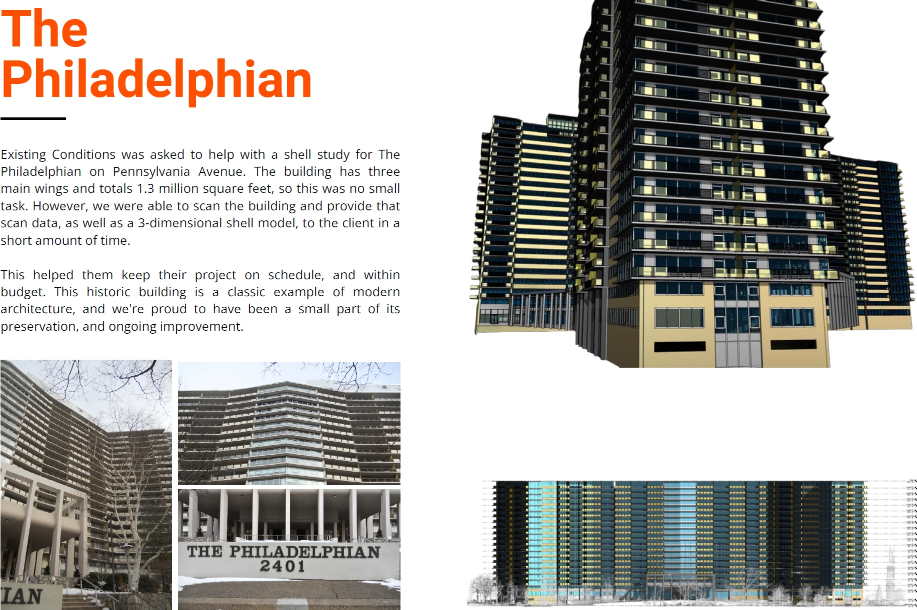
The Atlantic Building
Crumbling Terra Cotta and stone elements posed a danger to the safety of pedestrians below and to the integrity of the building envelope.
Using the latest in 3D scanning technology, we documented the existing conditions of all exterior elevations and roofs and provided the restoration architect with accurate information for them to do their work.
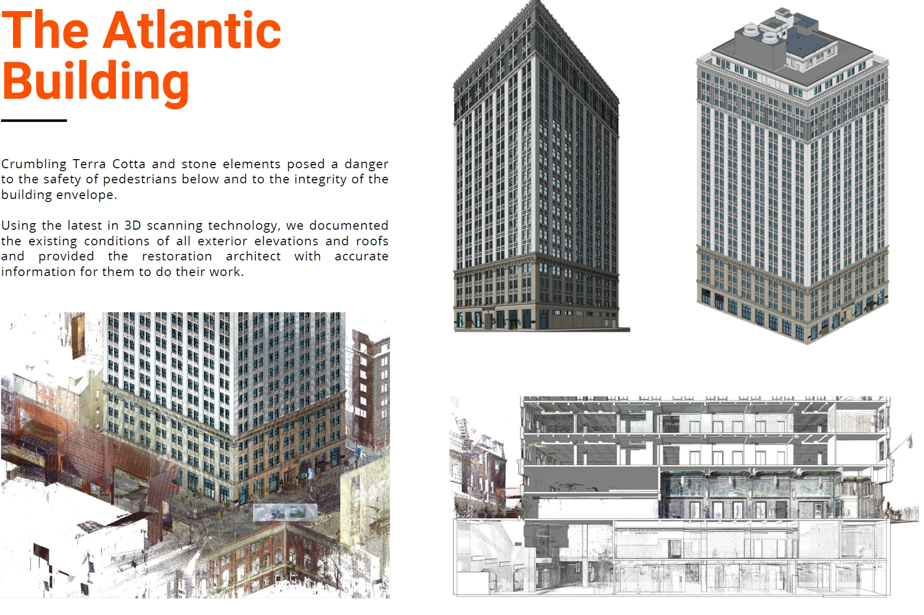
AIA Philadelphia
Existing Conditions was selected to document an estimated 20,000 square feet of space at 1218 Arch Street. To help the team know their building inside and out, Existing Conditions used 3D laser scanning and BIM to accurately and cost-effectively document the space.
The Center of Architecture’s K-12 programming has grown exponentially in recent years, prompting an occupied rehab of the existing building. By starting from an accurate point of departure, the center’s renovation will help spark the vibrancy of the community and improve the lives of its members.
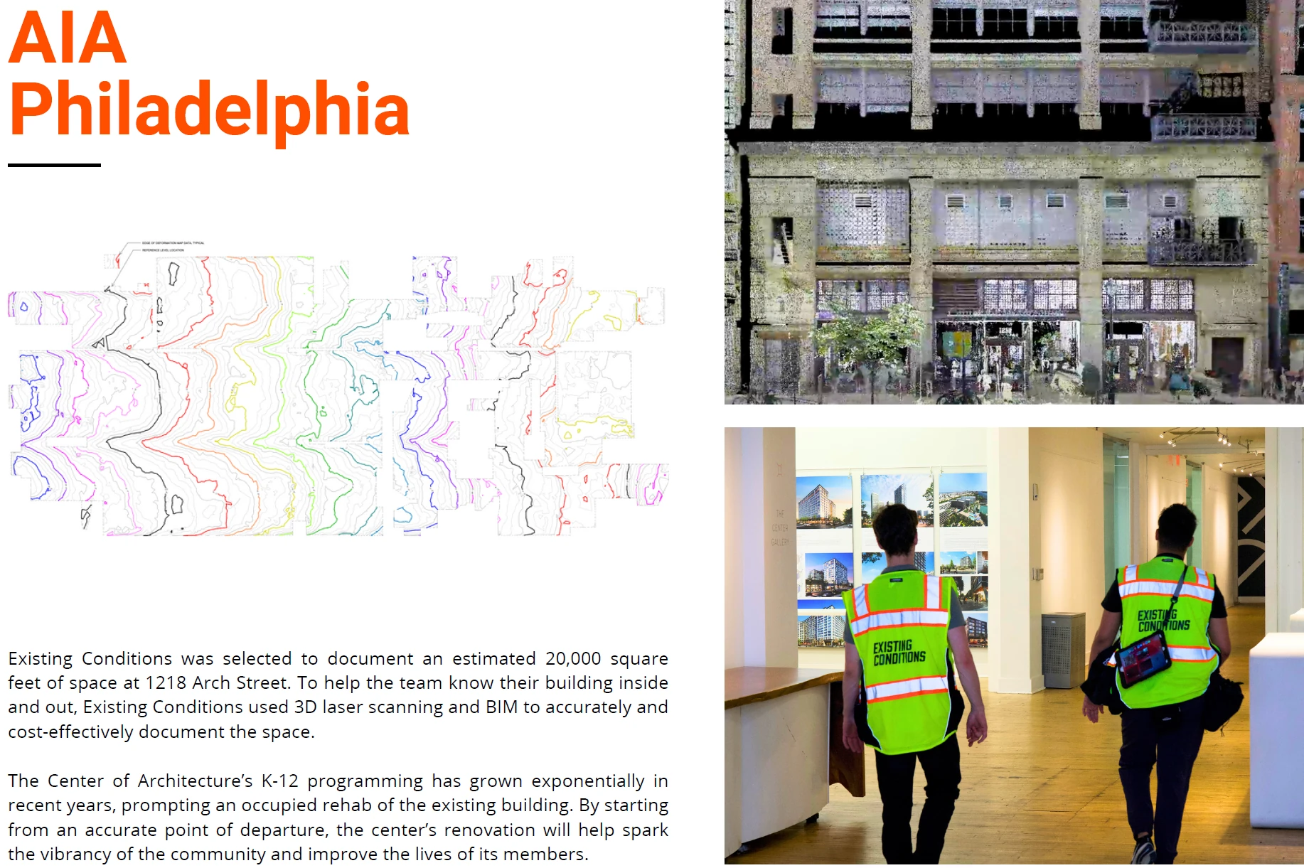
Leidy Laboratories of Biology
Leidy Laboratories of Biology, owned by the prestigious University of Pennsylvania, is a variation on the later seventeenth-century themes of Cope and Stewardson's Towne and Medical Buildings.
Existing Conditions was selected by a leading mechanical engineering firm to provide 3D laser scanning and 3D modeling of the mechanical systems of this academic building.
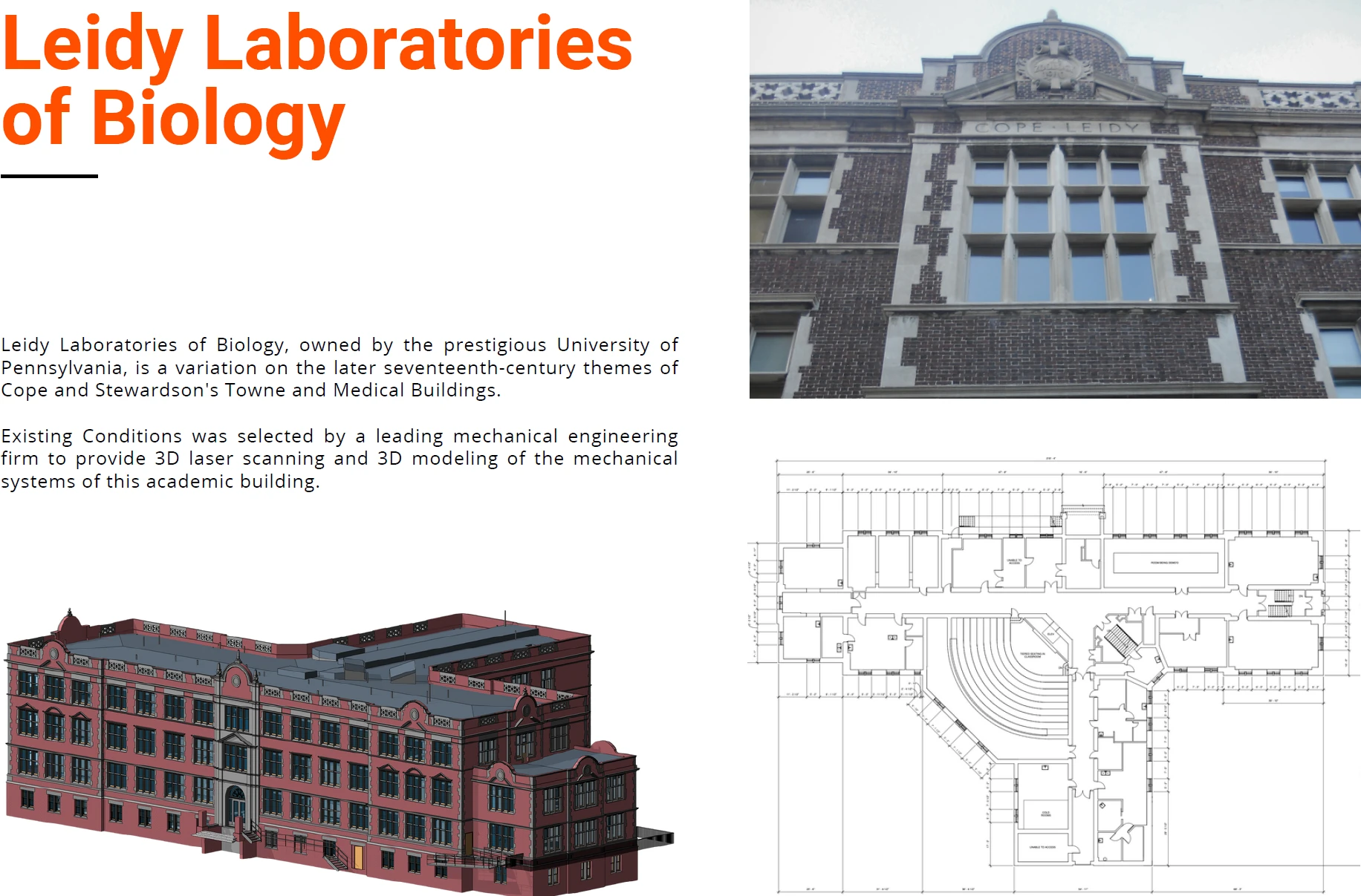
Aloft Philadelphia Downtown
Built in 1920, this historic building was the original headquarters of the bank Liberty Title and Trust Company. Existing Conditions documented the building for a renovation project that converted it into the Aloft Philadelphia Downtown hotel but kept the large two-story interior of the bank and converted it into their lobby.
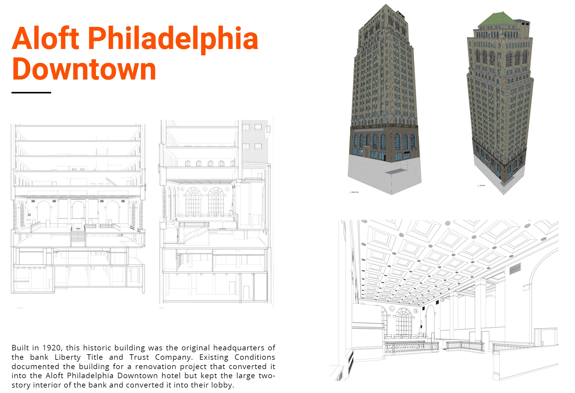
Drexel Trial Advocacy Building
This 100-year-old building was the Beneficial Bank Headquarters. Drexel took the building over and had Existing Conditions provide accurate documentation and a 3D BIM model of the building for their use in restoration.
This partnership underscores the confidence that institutions such as Drexel place in Existing Conditions to provide highly accurate documentation of their most valuable assets. It attests to our commitment to excellence and our capability to meet the standards set by prestigious projects.
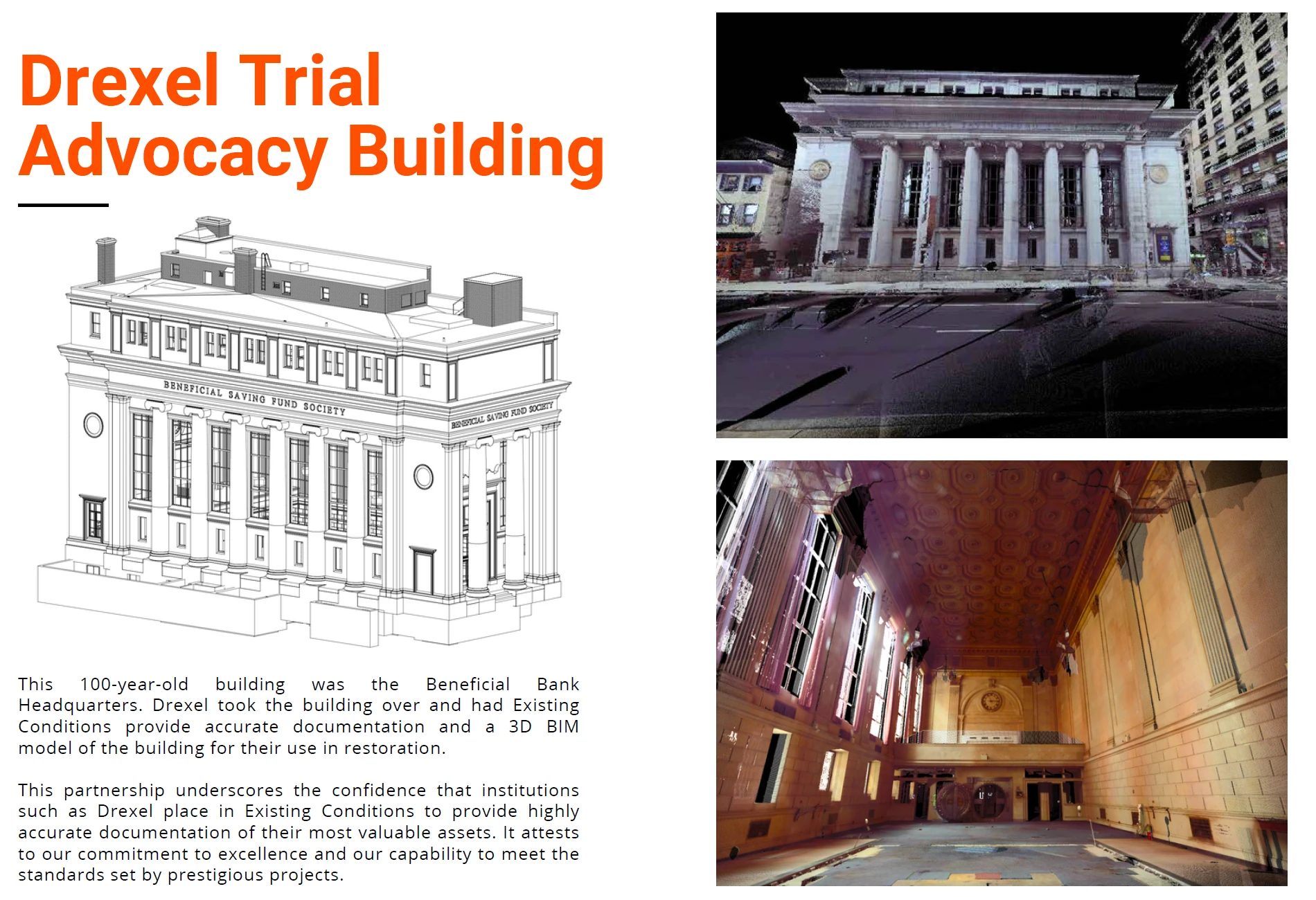
Presidential City Apartments
Existing Conditions was selected by a large national real estate development firm to document this mid-century multi-unit housing within a high-rise building. We deployed advanced 3D laser scanning technology and provided detailed existing conditions drawings.
These deliverables have proven essential in streamlining the comprehensive renovation process undertaken by our client. Presidential City Apartments, situated at 3900 City Avenue, now stands as a distinguished luxury apartment complex.
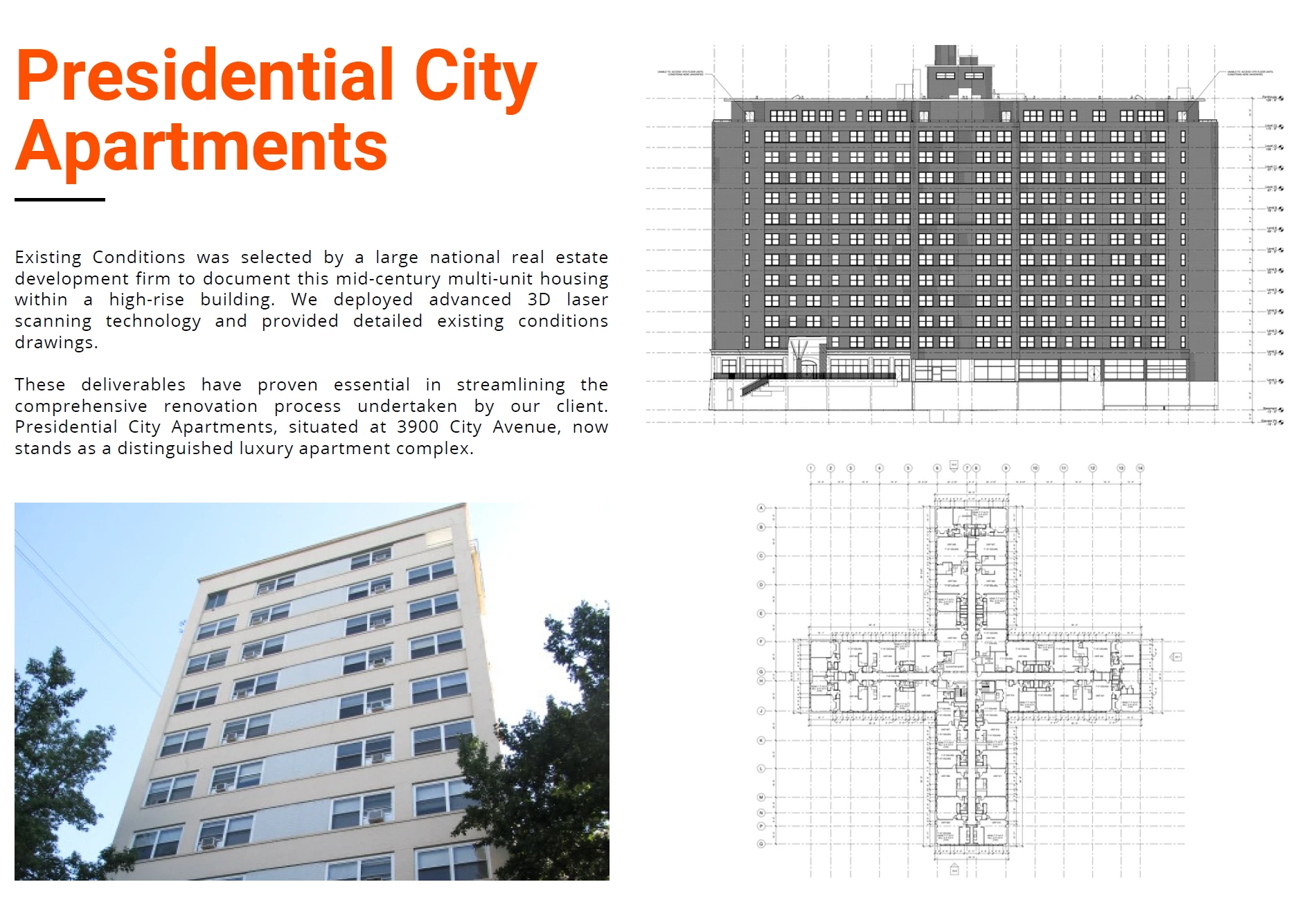
William Penn Charter School Head House
Existing Conditions was selected by Krieger + Associates Architects to document approximately 11,000 square feet of the William Penn Charter School's Alumni, Development, and Business Offices utilizing the Leica RTC360.
We delivered a 3D Revit model, exterior elevations, floor plans, roof plans, and building sections. Our accurate documentation provided our client with unparalleled situational awareness of their school's facilities.
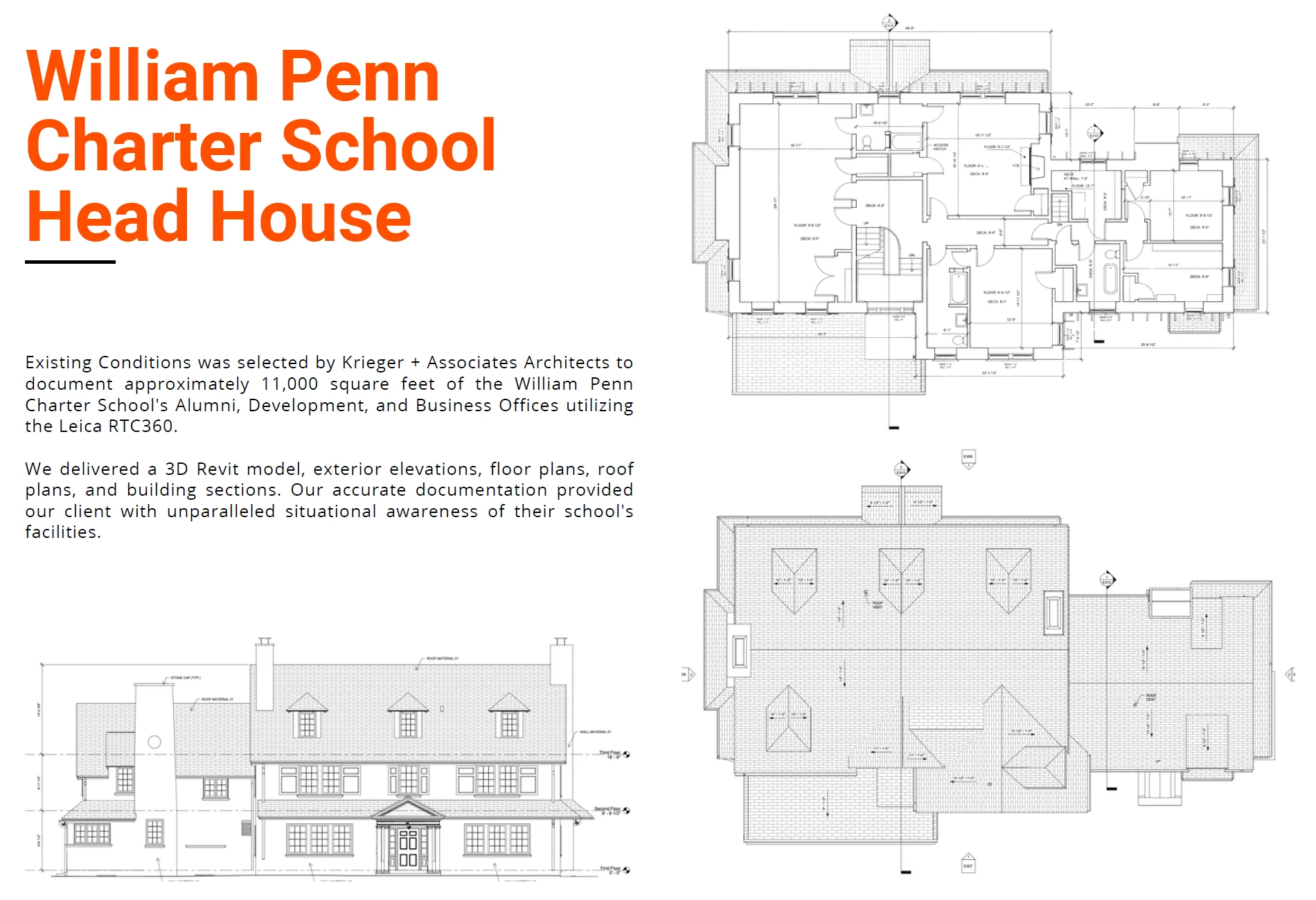
Existing Conditions 3D Laser Scanning Services
Over the past 27 years, we have measured, documented, and modeled over 10,000 buildings spanning over 700 million square feet across the United States, establishing ourselves as an industry leader in 3D laser scanning. Architects, builders, engineers, developers, and facility managers, trust us to deliver digital representations of the as-built environment with unparalleled accuracy and efficiency. Our dedicated Project Managers provide fast and accurate 3D laser scanning services and drone imagery services, and expert CAD and BIM technicians create custom, detailed deliverables. Our greatest reward remains delivering superior-quality scan-to-BIM work and knowing we played a vital role in our clients’ unique and historic projects.
Physical Limitations on Site When 3D Laser Scanning
In the world of 3D laser scanning, we understand that every site is unique, and some present special challenges due to their physical limitations. These limitations often revolve around issues of line-of-sight or the need for enhanced safety precautions. However, our expertise in 3D laser scanning allows us to navigate these challenges effectively. Here's how:
- Line-of-Sight Difficulties: Some sites pose challenges related to line-of-sight for 3D laser scanning equipment. This can occur when 3D laser scans need to be conducted safely from the ground or require a cautious distance due to site constraints. Despite these challenges, 3D laser scanning's non-contact nature makes it a powerful tool for addressing such complexities.
- Special Applications: Certain projects, like those involving healthcare facilities, may have unique requirements, such as 3D scanning above-ceiling MEP (Mechanical, Electrical, Plumbing) features while maintaining negative airflow or navigating congested interstitial spaces with limited access. 3D laser scanning's ability to capture data remotely and accurately makes it an ideal solution for tackling these complex scenarios.
Our commitment to precision and safety ensures that we can adapt to any site limitations and deliver the necessary data for your project. We leverage 3D laser scanning technology to provide comprehensive and reliable results, even in the most challenging environments.
Pricing for 3D Laser Scanning Services
What is the Cost for Existing Conditions 3D Laser Scanning Services?
In short, every job is unique and priced on a case-by-case basis. We don't use a "dollar-per-square-foot" metric or "rate sheet" to price a project. There are a number of key factors (illustrated below) that determine the cost of your 3D laser scanning project quote.
If you would like a cost estimate for 3D laser scanning services, please contact us to connect with a member of our team.
What Clients Do We Provide 3D Laser Scanning Services For?
Our clients include architects, builders, engineers, developers, facility managers, and other building industry professionals. As you can imagine, each discipline works with existing conditions 3D laser scanning, as-built drawings, 3D BIM models, MEP documentation, drone surveys in different ways for different projects. We can price jobs fairly and predictably because we've been doing this for over 27 years. We have a large database of quotes for every type of project imaginable, which enables us to get you the best possible price for your exact scope of work.
Existing Conditions has thrived for over two and a half decades because we've taken a very long-term view of how we serve our clients. We want to build relationships. We work with each client to help determine exactly what is needed to get the job done. We're very happy being a part of the client's team – providing point cloud data, as-built drawings, and Revit models of superior quality and at a reasonable price.
For a reasonable cost, our 3D laser scanning service helps clients avoid significant unpleasantness later on in their projects due to change orders, rework, and construction delays. Unfortunately, without accurate existing conditions data, drawings, and models these risks remain very real.
No matter the building type or project stage, Existing Conditions has calculated fair pricing for hundreds of similar deals. Because we focus solely collecting accurate as-built data and creating custom deliverables, we are able to create a quote for 3D laser scanning services for your exact project needs.
What Factors Determine Our Price for 3D Laser Scanning Services?
Every project is unique – and our work is driven by your scope. For instance, measuring and modeling a historic church is a very different professional exercise than creating as-built drawings for a manufacturing facility. And even with two similarly sized buildings, a client that is marketing their building for lease may have very different needs than a client who needs as-built drawings for an intensive renovation. Our team will quickly help you determine the right budget to meet your specific project needs.
That being said, there are a number of basic variables that determine the price of our 3D laser scanning services. They include:
- Location
- Square footage
- Building access and occupancy
- Project schedule and delivery speed
- Days required on site
- Types of drawings and models needed
- Level of detail required
- Complexity of the interior spaces and exterior facade
- Number of recommended scanning personnel
- Tools required to properly measure the space
- Other client requirements, such as overnight or weekend scanning
Our consultative sales process allows our team to fully understand your building and your project needs in order to get you precisely what you need – nothing more, nothing less. This ensures that your 3D laser scanning costs are reasonable and allows you to do your best work, no matter if you are an architect, consultant, builder, broker, or other building industry professional.
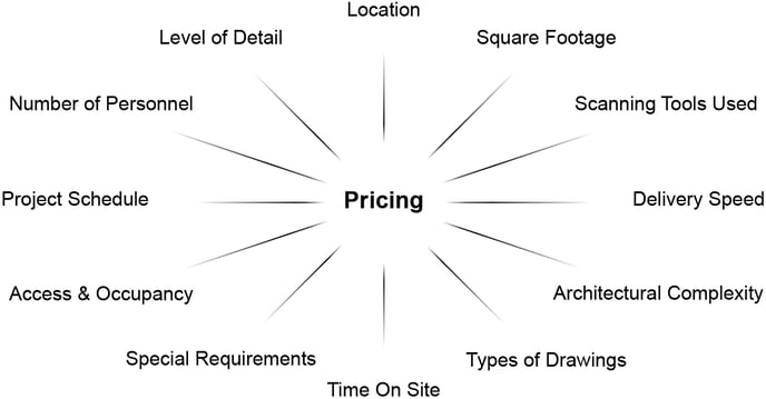
How Can We Be Responsive to Your Project Needs?
We can also execute projects in multiple stages to meet your specific budget requirements. We understand that financing a real estate project is a complex undertaking.
For instance, some clients will ask us to measure and model one area of a building in an initial phase and revisit the remainder of the building once project financing is fully secured.
Your success is our success – we have no interest in selling you on a scope of work that exceeds your needs.
In other scenarios, a client may only initially require a set of schematic "core and shell" floor plans. Perhaps they are performing their due diligence on an acquisition and have not yet closed on the property. Or maybe their project requires subsequent funding to complete the project. For these situations, Existing Conditions can produce an initial set of drawings from our laser scan data and then revisit the same scan data later on to produce more detailed drawings suitable for the final stages of a deal. If the client wants to add additional items to their scope of work a month or a year later, we've typically already collected the measurements required to produce the requested drawings.
This approach allows us to minimize the need for additional site visits and mobilization costs and speaks to the value of getting the job done right the first time while on site. Our flexibility is a major strength – we are your partner and want the best for your project, no matter the scope of work.
If we have sent you a quote that is beyond your budget or required scope, just let our team know. Our proposal is not carved in stone – we will work with you to meet your budget, schedule, and scope requirements. Our pricing is transparent and predictable – no hidden fees, no extras, and no unpleasant surprises when you receive your invoice upon delivery.
What Can Existing Conditions 3D Laser Scan?
3D laser scanning can essentially capture any site that requires high accuracy for documentation, analysis, or virtual exploration. 3D laser scanning can be used to capture a wide range of buildings and sites, including:
- Construction Sites
- Architecture, Adaptive Reuse
- Historic Buildings, Museums, Churches & Monuments
- Agricultural Facilities
- Industrial, Manufacturing & Distribution Facilities
- Office Buildings & Commercial Buildings
- Oil & Gas Facilities
- Power Plants & Process Plants
- Real Estate
- Recreation, Retail & Restaurant Locations
- Energy & Utilities
- Stadiums, Arenas, Theaters & Convention Centers
- Telecommunication Sites
- Government, Defense & Military Sites
- Schools & Universities
- Hospitals, Healthcare & Pharmaceutical Facilities
- Subsurface Utility & Concrete Markings
- HVAC & MEP (Mechanical, Electrical, and Plumbing) Features
- Water & Wastewater Treatment Plants
- Accident Sites & Incident Scenes
- 3D Tree Architecture
- Residential Properties, Homes & Apartments
- Infrastructure Projects, Bridges, Tunnels, Airports
Visit our portfolio, or contact us to connect with a member of our team.
What Deliverables Can Existing Conditions Provide?
- 3D Point Clouds
- 2D CAD Drawings, Floor Plans, Exterior Elevations, Building Sections, Reflected Ceiling Plans, and more
- 3D BIM Models
- 3D Mesh Models
- TruView Virtual Site Visit
- 3D Photogrammetry & 3D Virtual Tours
- Aerial Photogrammetry and Video
- Orthomosaic Maps and Orthomosaic images
- Custom Analysis and Calculations
Leverage Our Experience, Equipment, and Expertise
A huge part of our success for 27 years has been the partnerships we build with our clients, which have been fostered through clear communication. We listen carefully to our clients to understand exactly what they need. In turn, it is also important that our clients verify that we did not miss the mark. When you receive our quote, please carefully review our proposed Scope of Work.
We pride ourselves on functioning as "a known quantity" in an industry with innumerable uncertainties. Our clients consider Existing Conditions as an extension of their own teams. They leverage our experience, equipment, and expertise. Our personnel have backgrounds in architecture, construction, development, brokerage, and real estate finance. With that foundation, we are able to "speak your language" and deliver you exactly what you need for your specific project demands.
Having scanned and modeled thousands of buildings in virtually every asset class across the globe, we have built an unmatched portfolio and have thousands of repeat clients that trust us to meet their standards and specifications. Our brand is defined by competence, honesty, and performance.
ReCap 3D Scanning Software
ReCap reality capture 3D scanning software helps make building renovation, construction verification, and complex modeling projects more efficient.
Recap is an easy-to-use program that works with native point cloud files captured during 3D laser scanning. The “ReCap” part of the name is short for “reality capture”, and the system is included in the Autodesk Design Suite. ReCap allows you to create 3D models from captured data that can then be further designed within Autodesk.
Existing Conditions 3D Laser Scanning Services
Over the past 27 years, we have measured, documented, and modeled over 10,000 buildings spanning over 700 million square feet across the United States, establishing ourselves as an industry leader in 3D laser scanning. Architects, builders, engineers, developers, facility managers, trust us to deliver digital representations of the as-built environment with unparalleled accuracy and efficiency. Our dedicated Project Managers provide fast and accurate 3D laser scanning services and drone imagery services, and expert CAD and BIM technicians create custom, detailed deliverables. Our greatest reward remains delivering superior-quality scan-to-BIM work and knowing we played a vital role in our clients’ unique and historic projects.
Religious Building 3D Laser Scanning Services
Our team brings a wealth of experience to the realm of building documentation for religious spaces. Over the years, we've had the honor of contributing to some of the most iconic and historically significant religious projects in the United States, by 3D laser scanning churches, temples, cathedrals, mosques and synagogues. Our commitment to excellence in this specialized field is unwavering, driven by the unique demands and profound importance of religious spaces.
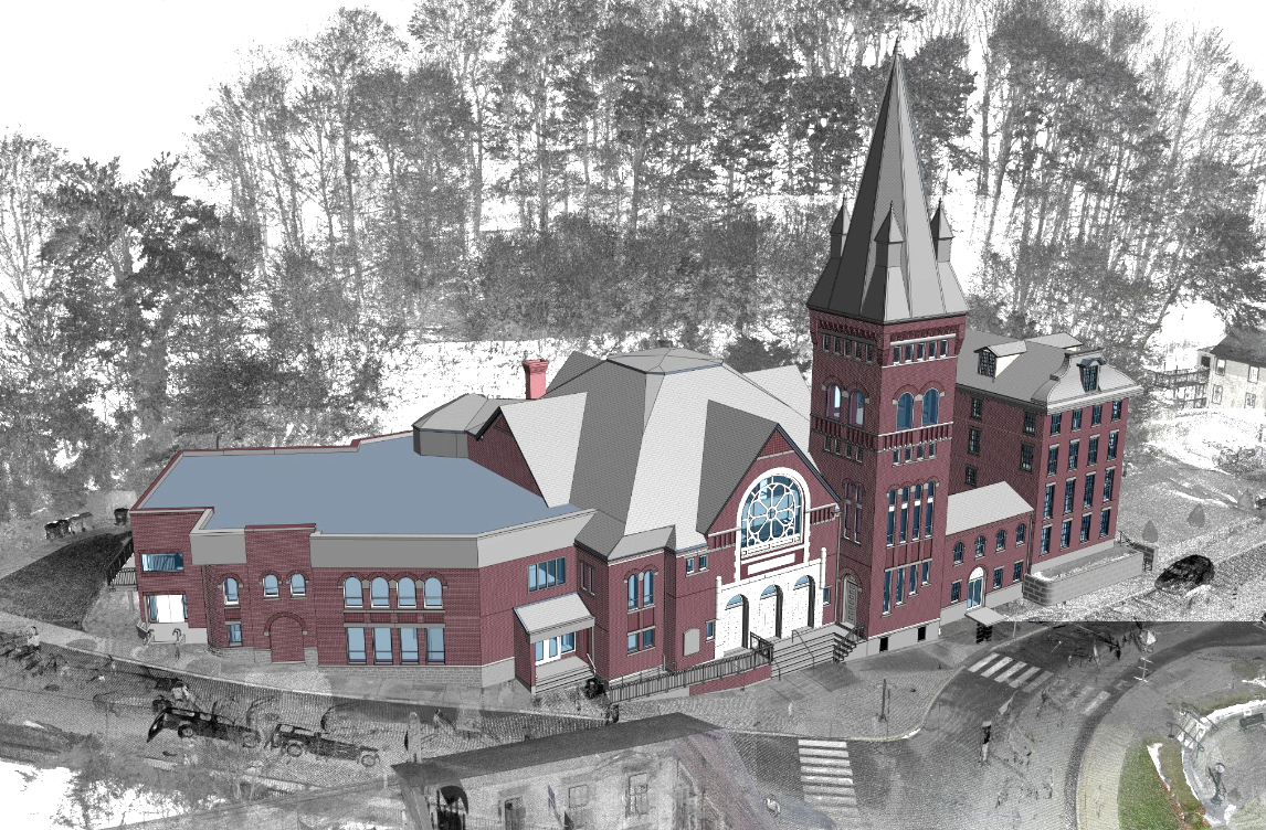
Historic Preservation:
Many religious buildings are not just places of worship but also cherished historic landmarks. Our team understands the significance of preserving these architectural gems. We meticulously document every detail, ensuring that the historical essence of these spaces is retained for future generations.
Accurate Spatial Data:
In religious buildings, precision matters more than ever. Our state-of-the-art 3D laser scanning technology captures accurate spatial data, down to the finest architectural intricacies. This level of precision is essential for renovations, restoration, or any architectural enhancements.
Sensitive Approach:
Religious spaces often require a sensitive and respectful approach. Our team is well-versed in working within these environments, understanding the need for minimal disruption and a considerate presence while documenting these sacred places.
Comprehensive Documentation:
We go beyond basic measurements. Our comprehensive documentation includes detailed 3D models, floor plans, elevations, and reflected ceiling plans. This wealth of information serves as a valuable resource for architectural planning and preservation efforts.
Tailored Solutions:
Every religious space is unique, with its own architectural character and challenges. We tailor our documentation services to meet the specific needs of each project, ensuring that our clients receive precisely the information required for their goals.
Collaborative Approach:
Collaboration is key in working on religious projects. We work closely with religious institutions, architects, and stakeholders to ensure that our documentation aligns with their vision and objectives.
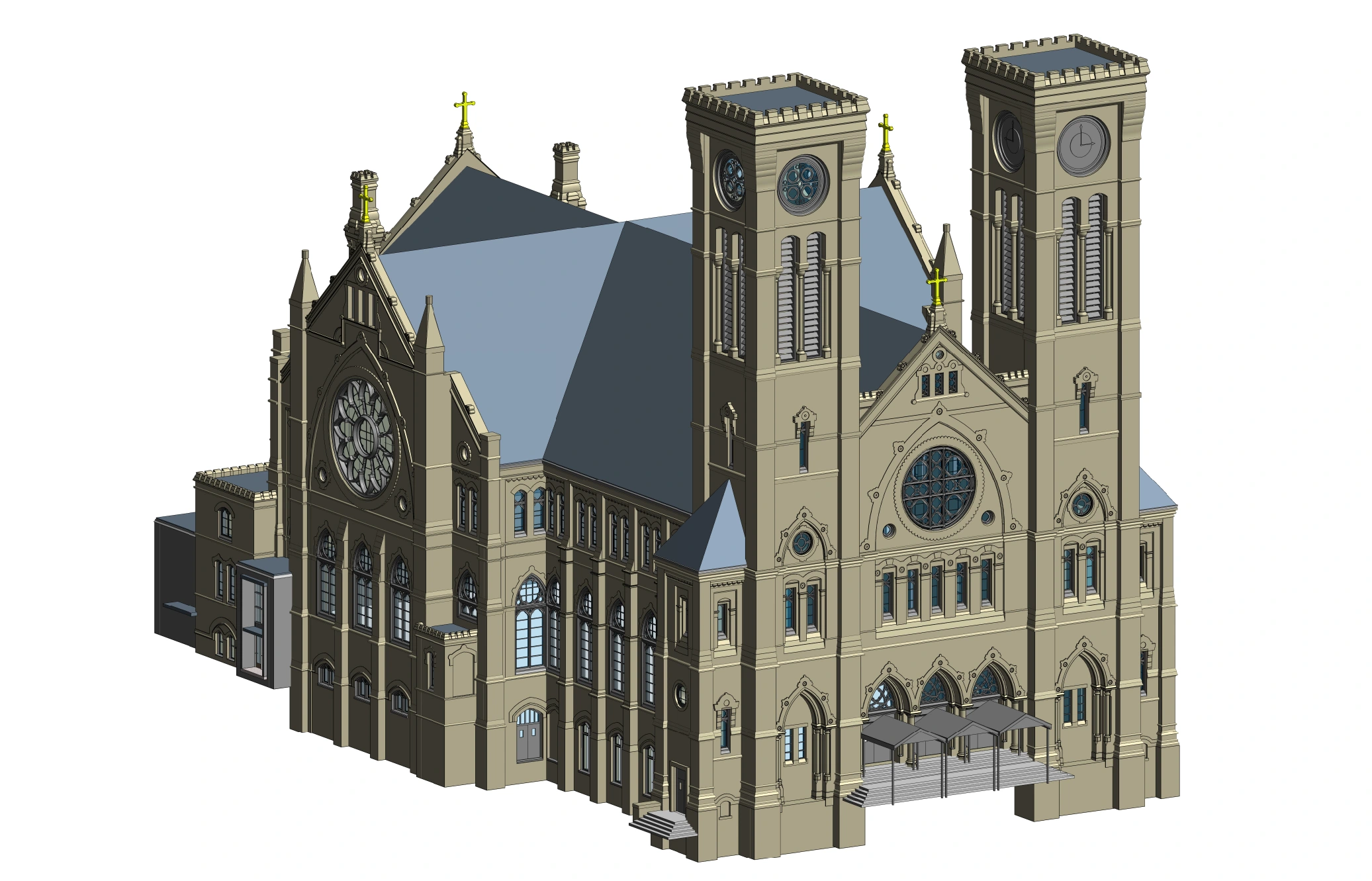
Learn More About 3D Laser Scanning Religious Buildings
Our dedication to delivering accurate and respectful building documentation for religious spaces stems from our deep respect for the cultural, historical, and spiritual significance these places hold. It's a privilege and a responsibility we hold dear, and we're committed to upholding the highest standards in this important field.
Existing Conditions 3D Laser Scanning Services
Over the past 27 years, we have measured, documented, and modeled over 10,000 buildings spanning over 700 million square feet across the United States, establishing ourselves as an industry leader in 3D laser scanning. Architects, builders, engineers, developers, facility managers, trust us to deliver digital representations of the as-built environment with unparalleled accuracy and efficiency. Our dedicated Project Managers provide fast and accurate 3D laser scanning services and drone imagery services, and expert CAD and BIM technicians create custom, detailed deliverables. Our greatest reward remains delivering superior-quality scan-to-BIM work and knowing we played a vital role in our clients’ unique and historic projects.
Residential Home 3D Laser Scanning Services
When it comes to 3D laser scanning residential homes, our team boasts decades of experience and expertise. Our portfolio proudly showcases our involvement in some of the most prestigious and historically significant residential projects across the United States.
We understand the unique demands and intricacies of preserving the charm and character of residential homes while delivering precise as-built documentation, 2D CAD drawings and 3D BIM models. Our commitment to excellence ensures that we meet and exceed the expectations of our clients in the realm of residential projects. We have the know-how and dedication to get the job done right, maintaining the integrity and beauty of these exceptional properties.
Residential Homes 3D Laser Scanning Experience and Expertise
Our team has decades of 3D laser scanning experience, delivering accurate building documentation for residential homes. We've had the privilege to work on some of the most historic and high profile homes in the United States, and we know what's required to get the job done right. Below is a selection of relevant projects we have measured and modeled in recent years.
1. Hopedene Mansion, Newport, RI, measured over 30,000 sq. ft.
2. 2101 Commonwealth Ave, Boston, MA, model of the full property, more than 25,000 sq. ft.
3. 181 Ocean Ave, Newport, RI, measured over 10,000 sq. ft.
4. 19 Smith’s Point, Manchester, MA, more than 15,000 sq. ft. of space
5. Belcourt Castle, Newport, RI, an assemblage of spaces totaling more than 30,000 sq. ft.
6. 441 Hale St, Manchester, MA, approximately 25,000 sq. ft.
7. Case House, Weston, MA, roughly 5,000 sq. ft.
8. Rough Point Mansion, Newport, RI, measured over 6,000 sq. ft.
9. 66 East 11th Street Penthouse, New York, NY, model of the full property
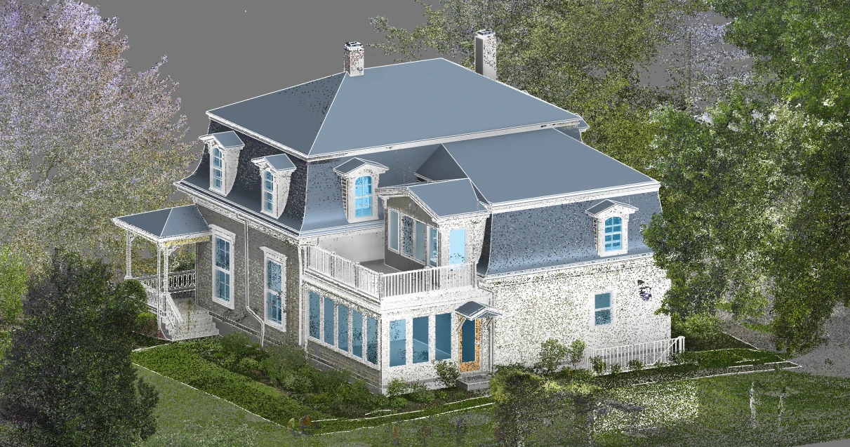
Residential Construction 3D Laser Scanning & Drone Services
Existing Conditions 3D laser scanning services and drone imagery services provide accurate, high-quality residential as-built drawings, models, and virtual tours that can be used to make decisions about every aspect of your home renovation project. The accurate LiDAR point clouds we capture removes human error from the documentation process, and can be transformed into 2D CAD drawings, floorplans, elevations, sections, reflected ceiling plans, 3D BIM models, and drone video and images, delivering precise as-built details to plan renovations, maintenance, and repairs. Incorporating 3D laser scanning into your residential construction project is a strategic investment that can lead to substantial cost savings over time.
As-Builts for Homeowners
Quickly capture the exterior features such as façade and roofline, and interior layout and dimensions of your home, including architectural, structural, mechanical, electrical, and plumbing features, like walls, windows, doors, HVAC systems, electrical wiring, and piping. We understand that your time is valuable, which is why we work efficiently to deliver the as-built data you need in a timely manner.
What are the Benefits of 3D Laser Scanning Residential Homes?
Accurate and Efficient Data Capture
When as-built drawings do not match the current conditions, making changes to the property could result in costly mistakes during construction. We have extensive experience working with homeowners, who trust us to deliver residential as-built documentation with unparalleled accuracy and efficiency.
Reliable Documentation
Our 3D laser scanning services, 2D CAD drawings, 3D BIM models, and drone video & imagery provide comprehensive as-built measurements of existing site conditions to better estimate renovation costs and avoid unnecessary demolition or rework due to inaccurate assumptions about the house layout.
Streamline Workflows
Accurate as-builts help to coordinate with architects and contractors for smoother project execution. By trusting the experts at Existing Conditions, you will receive exact locations of structural elements, MEP, and utility lines to prevent errors and accidents during renovations, ensuring that accuracy and safety is maintained throughout any construction work.
Improved Collaboration
Utilize accurate digital data and models to improve communication and coordination with your team, identify hazards to keep all workers safe, reduce errors and reworks, and deliver your project on time and on budget.
Existing Conditions 2D CAD Drawing & 3D BIM Model Deliverables
Architectural Layouts: Floor plans, elevations, sections, and RCPs showing the current configuration of walls, doors, windows, and more to document a building’s layout.
Structural Details: Up to date information about load-bearing walls, beams, columns, and foundation systems to understand a building's structural integrity and constraints.
Building Dimensions: Accurate measurements of all spaces, including heights, widths, and depths to avoid discrepancies during design.
MEP Systems: Location and layout of HVAC systems, electrical wiring, plumbing, and fire protection systems for redesign or upgrades.
Material Specifications: Details on existing materials used in walls, floors, roofs, and finishes for construction or renovation planning.
Condition Assessments: Documentation of the building’s current condition, identifying issues such as cracks, leaks, or wear that may require attention.
Existing Conditions 3D Laser Scanning Services
Over the past 27 years, we have measured, documented, and modeled over 10,000 buildings spanning over 700 million square feet across the United States, establishing ourselves as an industry leader in 3D laser scanning. Architects, builders, engineers, developers, facility managers, trust us to deliver digital representations of the as-built environment with unparalleled accuracy and efficiency. Our dedicated Project Managers provide fast and accurate 3D laser scanning services and drone imagery services, and expert CAD and BIM technicians create custom, detailed deliverables. Our greatest reward remains delivering superior-quality scan-to-BIM work and knowing we played a vital role in our clients’ unique and historic projects.
Risk Management with 3D Laser Scanning
Construction-grade 3D laser scanning is a powerful tool for mitigating risk at every stage of a project's lifecycle. The foundation of any successful project lies in accurate existing conditions, and our commitment to precision ensures that your project starts on solid ground. Here's how our expertise in 3D laser scanning contributes to risk management:
- Enhancing Stakeholder Relationships: Accurate and reliable data builds trust with stakeholders, fostering stronger relationships with architects, engineers, builders, and project owners. When everyone has confidence in the data, collaboration becomes smoother, and decision-making is more informed.
- Cost-Saving Benefits: Our technology and methodology reduce the likelihood of costly errors and rework. By providing a comprehensive digital footprint of the existing space, potential clashes and issues are identified early, resulting in significant cost savings over the course of the project.
- Fewer Delays and Interruptions: Construction delays are often caused by unforeseen issues or discrepancies between the plan and the actual conditions on-site. With our laser scanning and precise documentation, such delays are minimized. The ability to identify and address potential obstacles proactively keeps your project on track.
- Fewer Safety Risks: Safety is paramount in construction, and accurate data helps minimize safety risks. By knowing the precise conditions of a site, safety measures can be tailored to the specific challenges, reducing accidents and injuries.
Existing Conditions 3D Laser Scanning Services
Over the past 27 years, we have measured, documented, and modeled over 10,000 buildings spanning over 700 million square feet across the United States, establishing ourselves as an industry leader in 3D laser scanning. Architects, builders, engineers, developers, facility managers, trust us to deliver digital representations of the as-built environment with unparalleled accuracy and efficiency. Our dedicated Project Managers provide fast and accurate 3D laser scanning services and drone imagery services, and expert CAD and BIM technicians create custom, detailed deliverables. Our greatest reward remains delivering superior-quality scan-to-BIM work and knowing we played a vital role in our clients’ unique and historic projects.
Rooftop Solar Structure 3D Laser Scanning Services
Drawing from our extensive 3D laser scanning experience spanning several decades, our team specializes in providing precise and tailored documentation for rooftop solar projects. Throughout our journey, we have had the honor of contributing our expertise to some of the most iconic and historically significant rooftop solar initiatives across the United States.
Rooftop solar projects are at the forefront of sustainable energy solutions, and they demand meticulous planning and execution. Our wealth of experience in this field equips us with a deep understanding of the unique requirements and complexities associated with rooftop solar installations.
We recognize that rooftop solar projects go beyond traditional architectural documentation; they represent a crucial step towards a greener and more sustainable future. As such, our commitment to accuracy and attention to detail extends to every facet of these projects, from the precise positioning of solar panels to the intricate electrical and structural considerations.
Our 3D laser scanning services are designed to facilitate the implementation of rooftop solar solutions efficiently and effectively. We understand the significance of harnessing solar energy for both environmental and economic benefits, and our work reflects this commitment to sustainability.
Whether it involves historic structures or contemporary developments, we have the knowledge and skills required to ensure that rooftop solar projects are executed flawlessly. Our dedication to delivering accurate as-built drawings and models is a testament to our commitment to advancing the cause of clean and renewable energy.
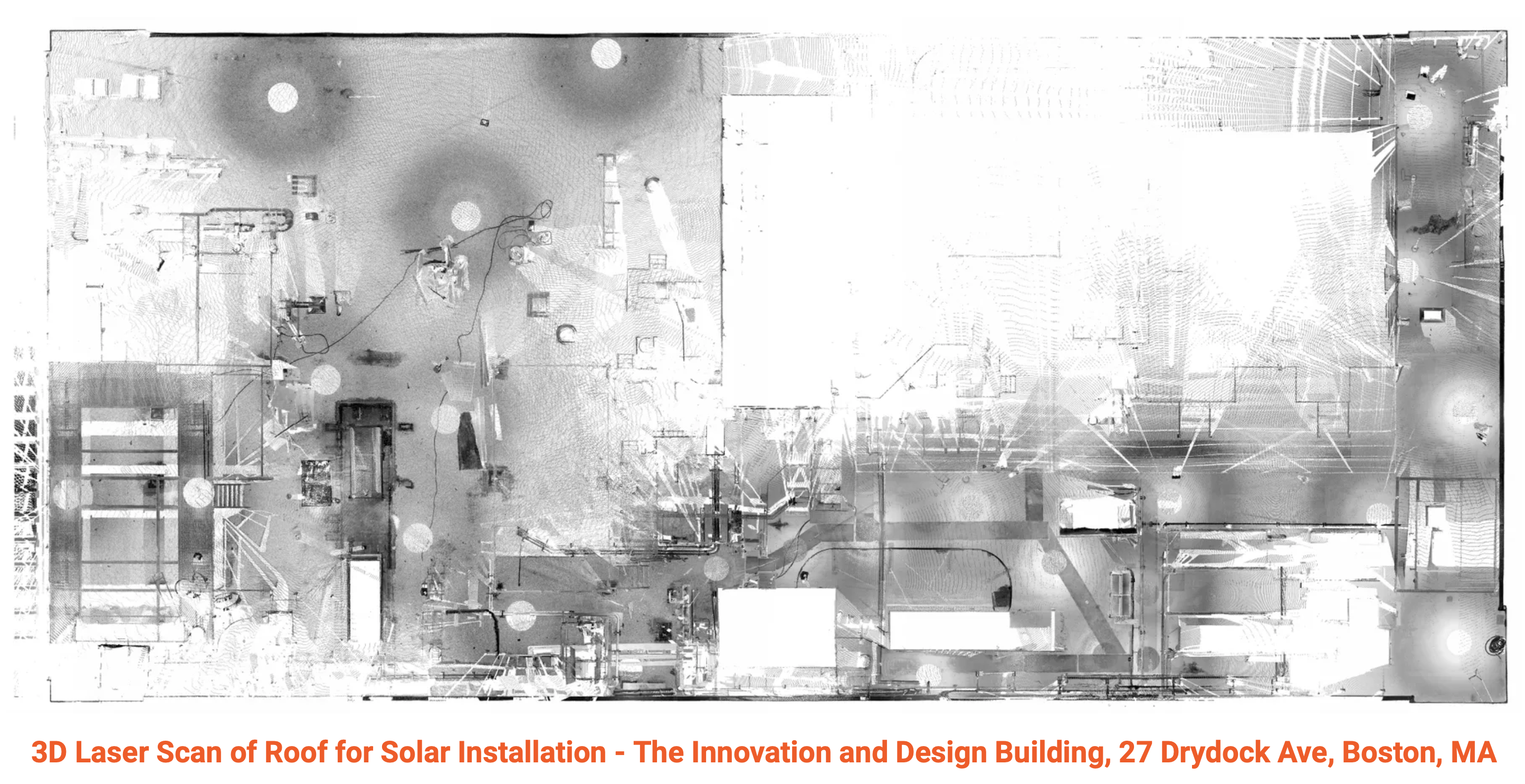
Solar Roof Experience and Expertise
Our team has decades of experience when it comes to delivering accurate building documentation for solar roof installations. We've had the privilege to work on some of the most challenging and high pro le solar projects in the United States, and we know what's required to get the job done right. Below is a selection of relevant projects we have measured and modeled in recent years.
1. The Innovation and Design Building, 27 Drydock Roof, Boston, MA
2. The Auburn Mall, Auburn, Massachusetts
3. 7320 West Bellaire Ave, Los Angeles, California
4. 11308 Penrose Street, Los Angeles, California
5. 101 Constitution Drive, Boston, Massachusetts
6. University of Massachusetts, McCormick Building Roof, Dorchester, Massachusetts
7. Yale University Sterling Chemistry Lab, New Haven, Connecticut
8. The Winchester Gun Factory, New Haven, Connecticut
9. The Hudson Mill, Hudson, Massachusetts
10. The American Locomotive Factory, Providence, Rhode Island
Existing Conditions 3D Laser Scanning Services
Over the past 27 years, we have measured, documented, and modeled over 10,000 buildings spanning over 700 million square feet across the United States, establishing ourselves as an industry leader in 3D laser scanning. Architects, builders, engineers, developers, facility managers, trust us to deliver digital representations of the as-built environment with unparalleled accuracy and efficiency. Our dedicated Project Managers provide fast and accurate 3D laser scanning services and drone imagery services, and expert CAD and BIM technicians create custom, detailed deliverables. Our greatest reward remains delivering superior-quality scan-to-BIM work and knowing we played a vital role in our clients’ unique and historic projects.
Scene LT FARO Laser Scanning Software
Scene LT is a piece of free software created specifically for viewing FARO laser scanner scan data. SCENE LT is a free viewer used to view, process, and manage existing point clouds and workspaces generated by the FARO® Laser Scanner Focus and SCENE.
SCENE LT includes filtering, automatic object recognition, simple measurement capability, 3D visualization, meshing, exporting scan data to various point-cloud and CAD formats, and importing CAD models in VRML format for comparing them with point-cloud data. With SCENE LT you can share scan data with work groups and partners in WebShare Cloud, where you can use a standard web browser to view the scan data.
If your project folder contains a “Scene Scan Data” folder, then you should consider downloading and using the Scene LT software and files. Here is the page to download Scene LT. Click on this link to download the free software and fill out the info form.
The Scene LT file format is a ZIP file which contains a set of folders and files. This data contains the 3D Panoramic view of the scan data for each scanner location. You will need to unzip these files and then open the "FWS" file in Scene LT to view the scan data.
Once Scene LT is installed, go to the setting icon in the upper right (gear icon) and click the button at the top labeled "Switch User Interface." This will set the user interface to allow the opening of FWS files.
Mac users will need access to a Windows machine in order to install this software.
Alternatively, Existing Conditions' Virtual Site Visits platform is an easy and low cost way to access spatial data of your building or project, regardless of your operating system or hardware. You can use the platform on any desktop, tablet, or mobile device – all you need is an internet connection.
Existing Conditions 3D Laser Scanning Services
Over the past 27 years, we have measured, documented, and modeled over 10,000 buildings spanning over 700 million square feet across the United States, establishing ourselves as an industry leader in 3D laser scanning. Architects, builders, engineers, developers, facility managers, trust us to deliver digital representations of the as-built environment with unparalleled accuracy and efficiency. Our dedicated Project Managers provide fast and accurate 3D laser scanning services and drone imagery services, and expert CAD and BIM technicians create custom, detailed deliverables. Our greatest reward remains delivering superior-quality scan-to-BIM work and knowing we played a vital role in our clients’ unique and historic projects.
\
Schools, Universities, College, and Campus 3D Laser Scanning Services
3D Laser Scanning Services for Schools, Universities, Colleges, and Campuses
Existing Conditions provides 3D laser scanning services for schools, universities, colleges, and campuses to support site renovations and upgrades. From entire schools to campus buildings to stadiums and mechanical rooms, Existing Conditions has extensive experience providing as-built documentation for schools, universities, colleges, and institutions. Existing Conditions 3D laser scanning services capture the exact architectural, structural, and MEP system layout and dimensions to support site renovations and upgrades, delivering as-built data to coordinate construction plans, reduce change orders, and save time.
Existing Conditions' Project Managers use industry-leading Leica survey-grade laser scanners to capture accurate existing site conditions in the form of a point cloud. Our in-house Mapping & Modeling Team can transform those point clouds into customized 2D CAD drawings, 3D BIM models, 3D mesh models, TruViews, and 3D virtual tours at any level of detail for visualization, analysis, design, construction, and renovation.
Existing Conditions brings expertise in many areas, including engineering, architecture, information technology, and construction. Having this combination of knowledge is integral to providing your team with the accurate data, drawings, and models that will save time and money on your next project or renovation.
Our team boasts an extensive legacy of expertise in providing precise building documentation for preparatory schools and high schools. Over the course of several decades, we've had the honor of contributing our 3D laser scanning services to some of the most renowned and prestigious academic projects in the United States. This rich experience has equipped us with an in-depth understanding of the unique demands and intricacies associated with academic building documentation.
Preparatory schools and high schools play a vital role in shaping the educational landscape, and their facilities often hold historical, architectural, and functional significance. Our team's proficiency extends to accurately capturing and documenting these unique attributes, ensuring that the essence and integrity of these educational institutions are preserved in our documentation.
The educational sector demands a meticulous approach to building documentation, encompassing everything from historic preservation to modern educational facility development. Our seasoned professionals are well-prepared to address the diverse needs and challenges posed by academic projects, enabling us to consistently deliver results of the highest caliber.
At the heart of our work lies an unwavering commitment to excellence, ensuring that your academic building project receives the comprehensive and precise documentation it requires. When entrusting us with your school, university, college, or campus building documentation needs, you can have confidence in our decades of 3D laser scanning experience and expertise, knowing that we have what it takes to get the job done right.
Existing Conditions 3D Laser Scanning Services
Over the past 27 years, we have measured, documented, and modeled over 10,000 buildings spanning over 700 million square feet across the United States, establishing ourselves as an industry leader in 3D laser scanning. Architects, builders, engineers, developers, facility managers, trust us to deliver digital representations of the as-built environment with unparalleled accuracy and efficiency. Our dedicated Project Managers provide fast and accurate 3D laser scanning services and drone imagery services, and expert CAD and BIM technicians create custom, detailed deliverables. Our greatest reward remains delivering superior-quality scan-to-BIM work and knowing we played a vital role in our clients’ unique and historic projects.
Existing Conditions 2D CAD Drawing & 3D BIM Model Deliverables
Architectural Layouts: Floor plans, elevations, sections, and RCPs showing the current configuration of walls, doors, windows, and more to document a building’s layout.
Structural Details: Up to date information about load-bearing walls, beams, columns, and foundation systems to understand a building's structural integrity and constraints.
Building Dimensions: Accurate measurements of all spaces, including heights, widths, and depths to avoid discrepancies during design.
MEP Systems: Location and layout of HVAC systems, electrical wiring, plumbing, and fire protection systems for redesign or upgrades.
Material Specifications: Details on existing materials used in walls, floors, roofs, and finishes for construction or renovation planning.
Condition Assessments: Documentation of the building’s current condition, identifying issues such as cracks, leaks, or wear that may require attention.
Sharing Point Cloud Data
How Do I Share Point Cloud Data?
Would you like to share point cloud data with your partners or collaborators? We’ve made it incredibly easy to do so in a safe and secure way.
First, be sure to save your project folder link for future deliveries, updates, or access. Then, forward the folder link to anyone who needs access to the point cloud data.
Downloading digital content from our Google servers or accessing files attached to our emails acknowledges our terms and conditions for file content.
Existing Conditions 3D Laser Scanning Services
Over the past 27 years, we have measured, documented, and modeled over 10,000 buildings spanning over 700 million square feet across the United States, establishing ourselves as an industry leader in 3D laser scanning. Architects, builders, engineers, developers, facility managers, trust us to deliver digital representations of the as-built environment with unparalleled accuracy and efficiency. Our dedicated Project Managers provide fast and accurate 3D laser scanning services and drone imagery services, and expert CAD and BIM technicians create custom, detailed deliverables. Our greatest reward remains delivering superior-quality scan-to-BIM work and knowing we played a vital role in our clients’ unique and historic projects.
Stadium and Performance Venue 3D Laser Scanning Services
3D Laser Scanning for Stadiums and Performance Venues
Leveraging our team's extensive 3D laser scanning expertise spanning several decades, we excel in providing precise and comprehensive building documentation tailored specifically for stadium projects. Over the years, we have had the distinct honor of contributing our 3D laser scanning knowledge and skills to some of the most renowned and historically significant stadium developments across the United States.
Stadium projects are iconic and multifaceted, often serving as cultural landmarks and hubs of entertainment and sports. These complex structures demand meticulous planning and documentation to ensure their successful construction, operation, and ongoing maintenance.
Our deep-rooted experience in this field equips us with an unparalleled understanding of the unique challenges and intricacies associated with stadium projects. From the structural engineering intricacies to the specialized systems required for modern stadiums, we are well-versed in delivering the accurate and comprehensive documentation needed to bring these grand visions to life.
We understand that stadiums hold a special place in the hearts of communities, fans, and athletes alike. Our commitment to accuracy and attention to detail extends to every aspect of our documentation services, from seating arrangements and accessibility to safety considerations and facility management.
Our as-built documentation plays a pivotal role in ensuring that stadium projects meet not only the highest standards of safety and functionality but also capture the essence of the sports and entertainment experiences they are designed to deliver. We take pride in our role in shaping the future of these iconic venues, contributing to the excitement and pride of communities across the nation.
What are the Benefits of 3D Laser Scanning Stadiums and Performance Venues?
- Elimination of costly return visits to the site
- More accurate, complete as-built surveys for design and renovation
- Minimized construction rework due to interferences
- Accurate measurements for fabrication
- Fast, unobtrusive scene capture
- Non-contact leaves sites untouched
- Accurate data to develop mixed reality experiences during sporting events
Existing Conditions 3D Laser Scanning Stadium Experience and Expertise
Our team has decades of experience when it comes to delivering accurate building documentation for stadiums. We've had the privilege to work on some of the most historic and high-profile stadium projects in the United States, and we know what's required to get the job done right. Below is a selection of relevant projects we have measured and modeled in recent years.
1. The TD Garden, Boston, Massachusetts
2. Madison Square Garden, New York, New York
3. The Curran Theater, San Francisco, California
4. The Fox Theater, Atlanta, Georgia
5. The Chase Theater, Providence, Rhode Island
6. Boston College Alumni Stadium, Chestnut Hill, Massachusetts
7. The Worcester Auditorium, Worcester, Massachusetts
8. The Victory Theater, Holyoke, Massachusetts
9. The Providence Performing Arts Center, Providence, Rhode Island
10. The Emerson Majestic Theater, Boston, Massachusetts
Download Our E-Book on Stadiums & Performance Venues
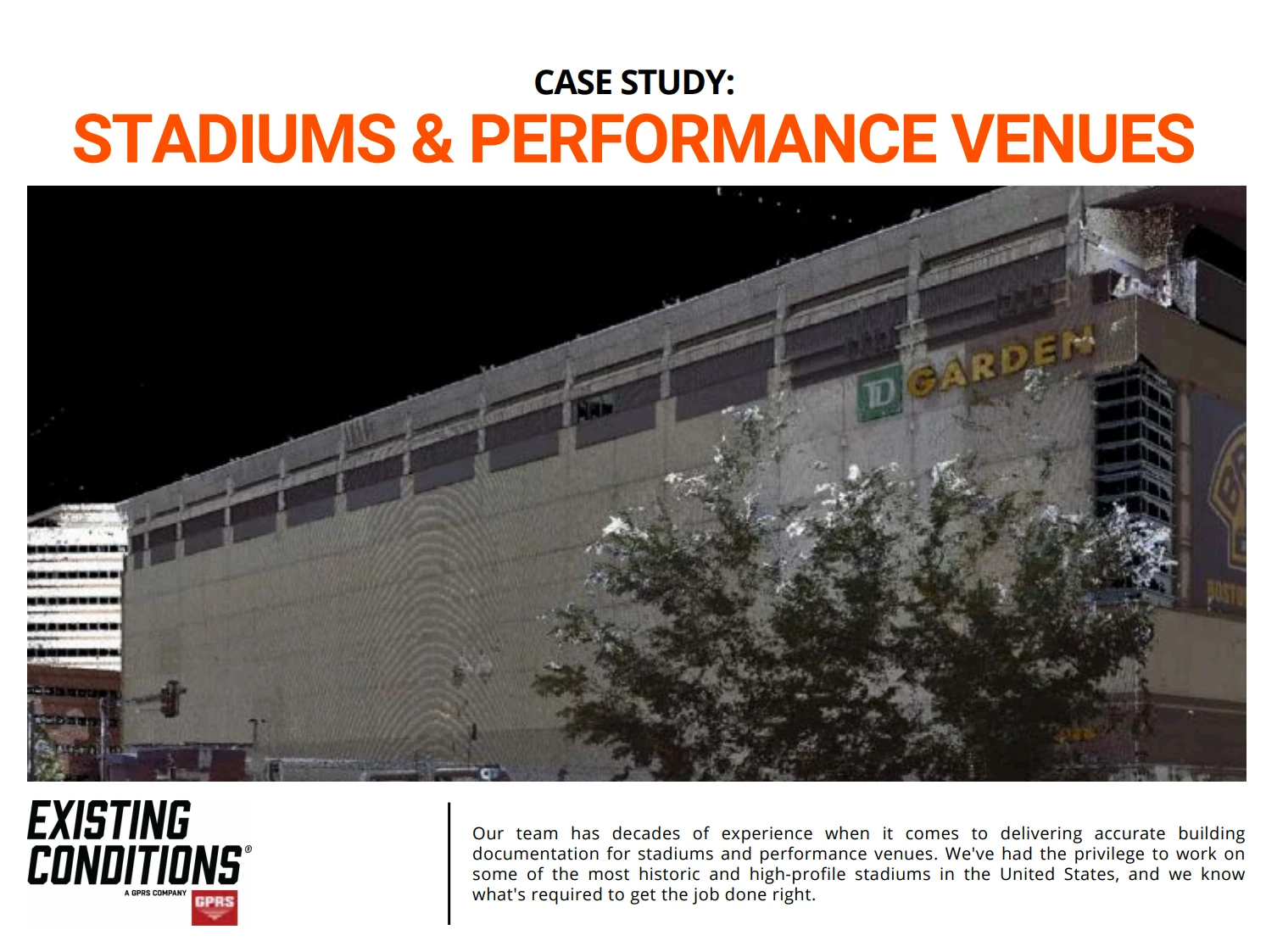
Existing Conditions 3D Laser Scanning Services
Over the past 27 years, we have measured, documented, and modeled over 10,000 buildings spanning over 700 million square feet across the United States, establishing ourselves as an industry leader in 3D laser scanning. Architects, builders, engineers, developers, facility managers, trust us to deliver digital representations of the as-built environment with unparalleled accuracy and efficiency. Our dedicated Project Managers provide fast and accurate 3D laser scanning services and drone imagery services, and expert CAD and BIM technicians create custom, detailed deliverables. Our greatest reward remains delivering superior-quality scan-to-BIM work and knowing we played a vital role in our clients’ unique and historic projects.
Structural System 3D Laser Scanning Services
3D laser scanning is a technology that uses light detection and ranging (LiDAR) to create a digital model of a structure's interior and exterior. This technology is often used in construction, engineering, and architecture to document the existing conditions of a building or site.
Existing Conditions has had the privilege to 3D laser scan some of the most sophisticated and challenging structural systems in the United States, and we know what's required to get the job done right.
Existing Conditions can include structural elements visible at the time of a 3D laser scan survey within our Revit models and CAD Drawings. Structural elements will typically be located and sized to the nearest 1/4".
Deflection and deformation of structural elements are not typically modeled, and details such as bolt size, weld sizes and lengths, and any structural analysis must be evaluated by a structural engineer.
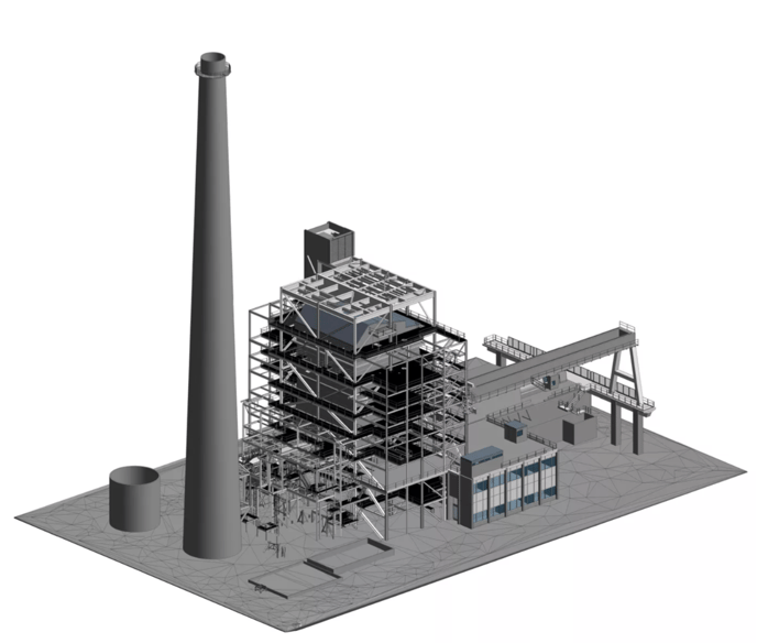
Parking Structure Experience and Expertise
Our team has decades of experience when it comes to delivering accurate building documentation for parking structures. We've had the privilege to work on some of the most complex and high-profile parking garages and parking projects in the United States, and we know what's required to get the job done right. Below is a selection of relevant projects we have measured and modeled in recent years.
1. 1 Ames Street Garage, Cambridge, Massachusetts
2. 1 Congress Street Garage, Boston, Massachusetts
3. Athena Health Complex Garage, Watertown, Massachusetts
4. 73 Mercer Street, New York, New York
5. Kendall Square Garage, Cambridge, Massachusetts
6. The Dock Square Garage, Boston, Massachusetts
7. 430 E 30th Street, New York, New York
8. 1 Post Office Square Parking Garage, Boston, MA.
9. 403 E 60th Street, New York, New York
10. 1330 West Fulton Street, Chicago, Illinois
Existing Conditions 3D Laser Scanning Services
Over the past 27 years, we have measured, documented, and modeled over 10,000 buildings spanning over 700 million square feet across the United States, establishing ourselves as an industry leader in 3D laser scanning. Architects, builders, engineers, developers, and facility managers, trust us to deliver digital representations of the as-built environment with unparalleled accuracy and efficiency. Our dedicated Project Managers provide fast and accurate 3D laser scanning services and drone imagery services, and expert CAD and BIM technicians create custom, detailed deliverables. Our greatest reward remains delivering superior-quality scan-to-BIM work and knowing we played a vital role in our clients’ unique and historic projects.
The Benefits of Digitizing a Building
The Benefits of Digitizing a Building
Unparalleled Precision and Accuracy
One of the foremost advantages of 3D laser scanning is its ability to provide incomparable precision and accuracy. This technology captures spatial data with a level of detail that surpasses traditional measurement methods. It ensures that every nuance of a building or property is faithfully represented in the digital footprint.
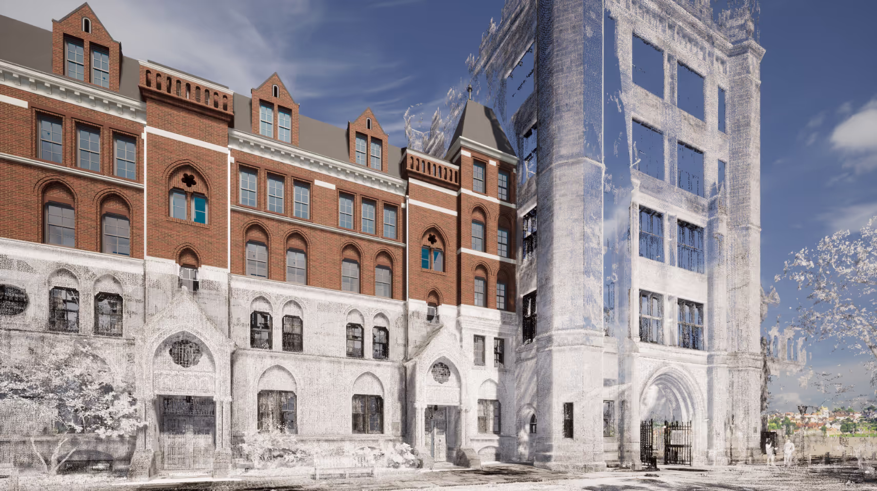
Enhanced Efficiency
3D laser scanning significantly improves efficiency across various industries. By swiftly collecting comprehensive data in a fraction of the time required by conventional approaches, it expedites project workflows and decision-making processes.
Comprehensive Understanding of Design
Digitized building documentation offers a better understanding of proposed designs. Architects, engineers, and stakeholders gain access to a rich visual representation that fosters clearer insights into the project's layout and potential challenges.
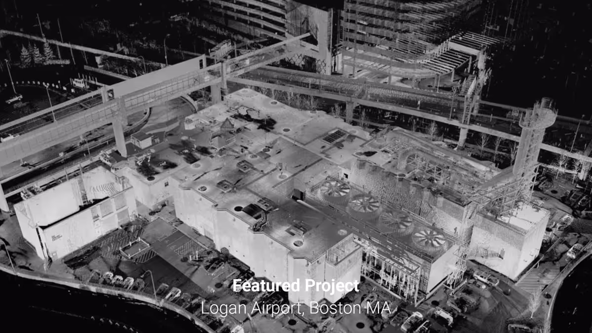
Reduced Site Visits
With digital documentation at their disposal, professionals can minimize the need for frequent site visits. This reduction in physical presence not only saves time and resources but also reduces disruptions to ongoing operations.
Cost Savings
3D laser scanning delivers substantial cost savings throughout the course of a project. By minimizing errors, rework, and costly mistakes, it optimizes budget allocation and prevents overruns.
Customer-Centric Approach
Digital documentation enhances customers' business models by providing them with a powerful asset. This data allows clients to make informed decisions, manage their properties effectively, and extract greater value from their investments.
Mitigation of Logistical Issues
The digital footprint mitigates logistical issues by offering a precise and accessible record of a building or property. It minimizes uncertainties, streamlines planning, and ensures smoother project execution.
Universal Data Accessibility
Digitized building data can be universally accessed by authorized parties. This accessibility promotes collaboration, facilitates informed decision-making, and supports remote monitoring and management.
Enhanced Security and Peace of Mind
The digital documentation adds a layer of security and peace of mind. In the event of unforeseen incidents or disputes, it provides an accurate historical record that can be referenced for validation and resolution.
Expanded Utility for Studies and Diagnostics
Beyond construction and design, digitized building data can be used for performing studies and diagnostics. It empowers professionals to analyze, simulate, and optimize building performance, sustainability, and functionality.
Increased Asset Value
Digitized documentation increases asset value by enhancing the management and maintenance of properties. It ensures that assets are better preserved, operate efficiently, and retain their worth over time.
Precise Cost and Schedule Control
Project managers benefit from precise control over costs and schedules. With accurate digital data, they can make informed decisions to keep projects on track and within budget.
Sustainability Benefits
Digitization contributes to sustainability efforts by promoting energy efficiency and reducing waste. It facilitates better resource management, lowers environmental impact, and aligns with green building practices.
Early Design Validation
Early design validation is facilitated through digital documentation. Architects and engineers can validate designs before construction begins, reducing the likelihood of costly design errors.
Governmental Adoption
Governmental bodies are increasingly adopting digitized documentation for regulatory compliance and urban planning. It aligns with modernization efforts and supports data-driven decision-making.
Streamlined Field Data Collection
3D laser scanning streamlines field data collection, making it quicker, safer, and more accurate. It empowers professionals with the tools they need to capture essential information efficiently.
If you'd like to learn more, visit our portfolio, or contact us to connect with a member of our team.
Theater & Amphitheater 3D Laser Scanning Services
Our team possesses a wealth of expertise in providing 3D laser scanning services to capture precise as-built documentation for theaters, convention centers, amphitheaters, performing arts centers, music halls, stages, and other venues. Over the years, we have been honored to contribute our knowledge and skills to some of the most renowned and historically significant theater projects across the United States.
The theater industry demands precision and attention to detail, and our extensive experience has equipped us with an in-depth understanding of the intricate requirements unique to this field. We recognize that theaters are not just architectural spaces; they are cultural treasures that require the utmost care and accuracy in their documentation.
Our commitment to excellence extends beyond the structural aspects, encompassing the comprehensive network of theatrical systems, acoustics, lighting, and stage equipment that are integral to the theatrical experience. We understand that theaters are dynamic spaces where artistic expression and technical precision converge, and our documentation reflects this multidimensional nature.
Whether it's preserving the historical integrity of a classic theater or facilitating the development of cutting-edge performance venues, we have the expertise to ensure that the job is executed with the highest degree of precision and professionalism. Our dedication to delivering accurate and reliable building documentation is a testament to our commitment to the vibrant world of theater and the communities it serves.
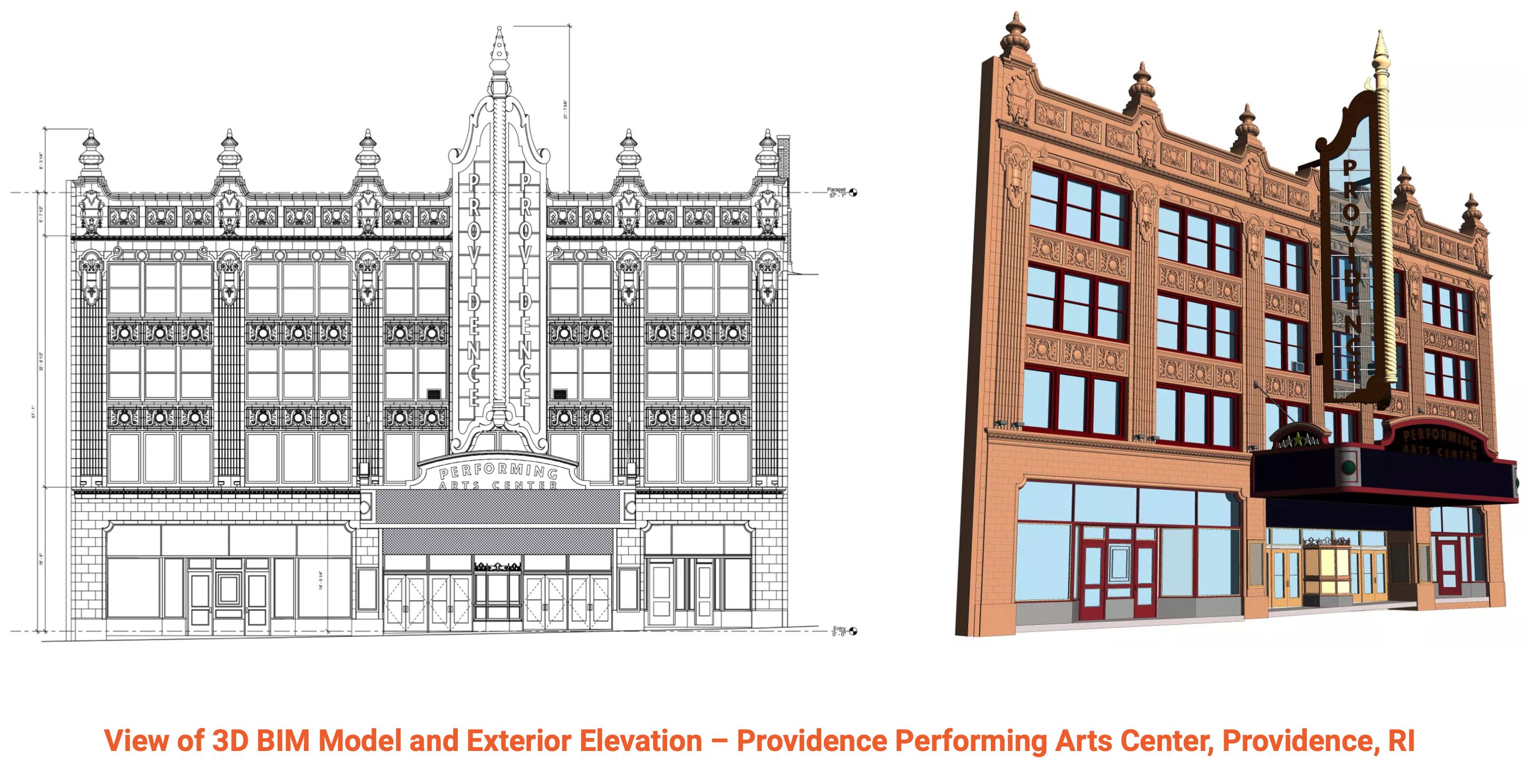
Existing Conditions 3D Laser Scanning Services
Over the past 27 years, we have measured, documented, and modeled over 10,000 buildings spanning over 700 million square feet across the United States, establishing ourselves as an industry leader in 3D laser scanning. Architects, builders, engineers, developers, facility managers, trust us to deliver digital representations of the as-built environment with unparalleled accuracy and efficiency. Our dedicated Project Managers provide fast and accurate 3D laser scanning services and drone imagery services, and expert CAD and BIM technicians create custom, detailed deliverables. Our greatest reward remains delivering superior-quality scan-to-BIM work and knowing we played a vital role in our clients’ unique and historic projects.
Troubleshooting 3D Laser Scanning File Access Issues
The best solutions are often the simplest. Sometimes simply refreshing your browser will allow you to see files and folders that were not previously visible.
Also, be sure to download the files one at a time. Attempting to download multiple files at a time will prompt the browser to zip the files, which is not advisable.
We use Google Drive for our file storage/sharing. Some IT departments limit or block access to Google Drive, so reach out to your IT administrator. If it is necessary to use another method of sharing large files, please let us know.
Please keep in mind that while Google Drive can provide access to the files, your computer will still need the appropriate software to open the files.
Existing Conditions 3D Laser Scanning Services
Over the past 27 years, we have measured, documented, and modeled over 10,000 buildings spanning over 700 million square feet across the United States, establishing ourselves as an industry leader in 3D laser scanning. Architects, builders, engineers, developers, facility managers, trust us to deliver digital representations of the as-built environment with unparalleled accuracy and efficiency. Our dedicated Project Managers provide fast and accurate 3D laser scanning services and drone imagery services, and expert CAD and BIM technicians create custom, detailed deliverables. Our greatest reward remains delivering superior-quality scan-to-BIM work and knowing we played a vital role in our clients’ unique and historic projects.
Understanding the Hardware: LiDAR & Phase-Based Scanning
LiDAR
The "time-of-flight" method
Laser Imaging, Detection, and Ranging (also called Light Detection and Ranging) or LiDAR, is based on a principle known as time-of-flight. This uses a pulsed laser to emit a beam, along with a mirror that deflects that beam toward the scan area, and finally, an optical receiver to detect the laser pulse and reflect it from the object to the scanner.
The time-of-flight method operates based on this formula: (Distance = (Speed of Light x Time of Flight) / 2). It uses the known speed of light and the time it takes for the laser pulse to be emitted, bounce off the object, and ultimately return to the 3D laser scanner to calculate the distance from the object to the scanner.
Although LiDAR 3D laser scanning does not collect data as quickly as phase-based scanning, it can be used from greater distances.
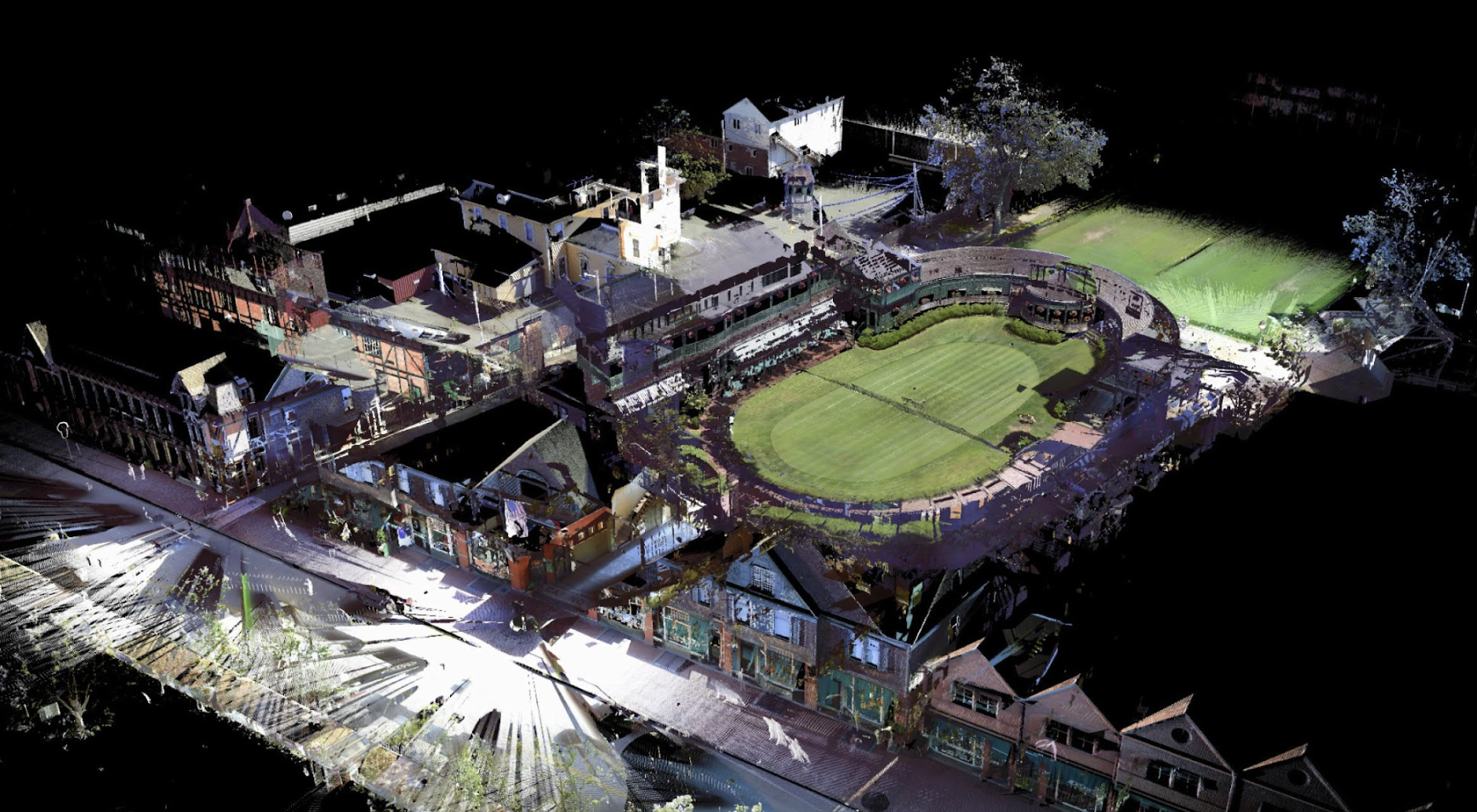
Phase-Based Scanning
The laser scanner emits a constant beam of energy
Phase-based 3D laser scanning emits a constant laser beam into multiple phases. It then compares the phase shifts of the returned laser energy. The laser scanner uses phase-shift algorithms to determine the distance, based on the unique properties of each individual phase based on this formula: (Time of Flight = Phase Shift / (2π x Modulation Frequency).
Phase-based scanners can collect data at a much faster speed than time-of-flight scanners, but their effective distance is much shorter. Additionally, phase-based scanners typically have more "noise," or false data, than time-of-flight scanners.
Existing Conditions 3D Laser Scanning Services
Over the past 27 years, we have measured, documented, and modeled over 10,000 buildings spanning over 700 million square feet across the United States, establishing ourselves as an industry leader in 3D laser scanning. Building professionals trust us to deliver digital representations of the as-built environment with unparalleled accuracy and efficiency. Our dedicated Project Managers provide fast and accurate 3D laser scanning services and drone imagery services, and expert CAD and BIM technicians create custom, detailed deliverables. Our greatest reward remains delivering superior-quality scan-to-BIM work and knowing we played a vital role in our clients’ unique and historic projects.
Washington, D.C. 3D Laser Scanning Services
As an architecture, engineering, or construction professional, you understand that projects require a tremendous amount of planning and coordination. Existing Conditions 3D Laser Scanning Services can deliver accurate as-builts, point clouds, 2D CAD drawings, 3D photogrammetry, and 3D BIM models to expedite project planning and reduce change orders, delays, and costs.
Whether you are a general contractor or facility manager planning renovations or modifications, or an architect or engineer who requires precise project data, Existing Conditions provides accurate existing conditions documentation, reality capture, and scan-to-BIM services to bring your design and construction projects in on time, and on budget.
When you need accurate architectural, structural, and MEP system dimensions, locations, and layouts for design, prefabrication, clash detection, facility modifications, or asset management, call Existing Conditions. 3D laser scanning minimizes shutdowns and disruptions, eliminates the need for site revisits, and provides accurate as-built data to reduce risk and increase project efficiency.
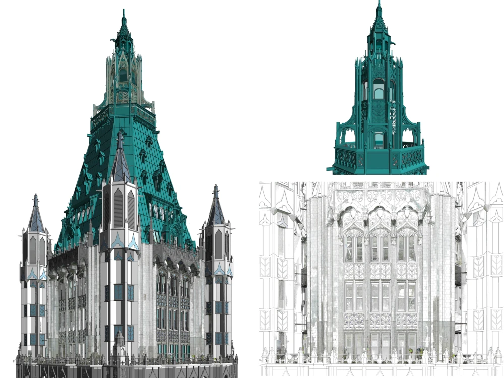
Existing Conditions 2D CAD Drawing & 3D BIM Model Deliverables
Architectural Layouts: Floor plans, elevations, sections, and RCPs showing the current configuration of walls, doors, windows, and more to document a building’s layout.
Structural Details: Up to date information about load-bearing walls, beams, columns, and foundation systems to understand a building's structural integrity and constraints.
Building Dimensions: Accurate measurements of all spaces, including heights, widths, and depths to avoid discrepancies during design.
MEP Systems: Location and layout of HVAC systems, electrical wiring, plumbing, and fire protection systems for redesign or upgrades.
Material Specifications: Details on existing materials used in walls, floors, roofs, and finishes for construction or renovation planning.
Condition Assessments: Documentation of the building’s current condition, identifying issues such as cracks, leaks, or wear that may require attention.
Existing Conditions 3D Laser Scanning Services
Over the past 27 years, we have measured, documented, and modeled over 10,000 buildings spanning over 700 million square feet across the United States, establishing ourselves as an industry leader in 3D laser scanning. Architects, builders, engineers, developers, and facility managers, trust us to deliver digital representations of the as-built environment with unparalleled accuracy and efficiency. Our dedicated Project Managers provide fast and accurate 3D laser scanning services and drone imagery services, and expert CAD and BIM technicians create custom, detailed deliverables. Our greatest reward remains delivering superior-quality scan-to-BIM work and knowing we played a vital role in our clients’ unique and historic projects.
What are Exterior Elevations As-Built Drawings?
Facades and Perimeter Views
As opposed to a “plan view” drawing where the perspective is looking down on the building, an elevation shows what the building looks like from the side. Exterior elevations are as-built drawings that show the exterior sides of the building, from ground level up to the top of the structure. An accurate set of exterior elevations provides the architect and their team with key information about the building – including height, proportion, windows, doors, decks, and other elements visible from the exterior. Exterior elevations also often include ornamentation and trim, depending on the project's needs.
Together with the floor plan and roof plan, the exterior elevations round out the typical set of as-builts that most of our architecture clients ask for on their projects.
While your specific project needs may differ, typically these building elements and finished spaces that are visible and accessible during our survey will be modeled orthogonally at a moderate level of detail:
- Exterior walls
- Changes in material noted
- Windows, doors, and curtain wall
- Porches
- Decks
- Loading Docks
- Parapets, canopies, skylights
- Exterior stairs to grade
- Not including coursing/carved floriated details)
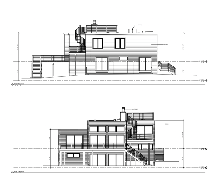
Existing Conditions 3D Laser Scanning Services
Over the past 27 years, we have measured, documented, and modeled over 10,000 buildings spanning over 700 million square feet across the United States, establishing ourselves as an industry leader in 3D laser scanning. Architects, builders, engineers, developers, facility managers, trust us to deliver digital representations of the as-built environment with unparalleled accuracy and efficiency. Our dedicated Project Managers provide fast and accurate 3D laser scanning services and drone imagery services, and expert CAD and BIM technicians create custom, detailed deliverables. Our greatest reward remains delivering superior-quality scan-to-BIM work and knowing we played a vital role in our clients’ unique and historic projects.
What are the Benefits of 3D Laser Scanning?
What are some of the benefits of 3D laser scanning?
With construction-grade 3D laser scanning, safe laser technology can calculate where in 3D space an object is. Our state-of-the-art laser scanners can capture millions of data points per second. The LiDAR data is stitched together, providing a three-dimensional representation of the existing space within line of sight of the scanner.
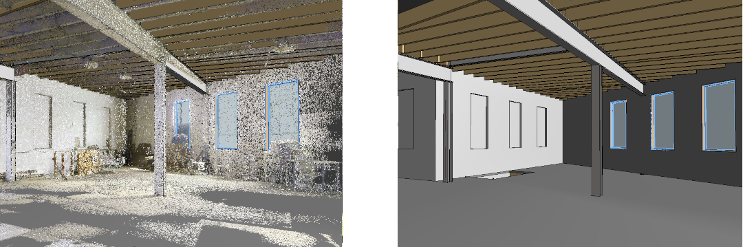
Millions of real-world data points
A single laser can capture millions of 3D data points per second, providing incredibly rich detail of every aspect of your project.
Collect a dimensionally accurate, 3D walkthrough of the project
Let us be your digital eyes in the field so you can navigate through your site virtually and even take spot dimensions.
Avoid errors
Laser scanning is not subject to human errors and provides more accurate measurements (down to millimeters) than what’s collected by tape measures or hand-held devices.
Answers unanticipated questions
While the scanner cannot see through walls, a 3D laser scan captures everything within line of sight up to 1,000 meters in a full 360 degrees from every scan location. This comprehensive scan reduces the need to revisit the project to answer unanticipated questions.
Reduce change orders and waste
The cost of a laser scan pales in comparison to the cost of change orders and construction delays.
Minimize shut-down times
Laser scanning is quick, safe, and non-intrusive – minimizing or eliminating operational shutdowns and client inconvenience. A full scan of your site gives you the ability to later add additional elements to the model and deliverables without necessarily requiring additional site visits.
Existing Conditions 3D Laser Scanning Services
Over the past 27 years, we have measured, documented, and modeled over 10,000 buildings spanning over 700 million square feet across the United States, establishing ourselves as an industry leader in 3D laser scanning. Architects, builders, engineers, developers, and facility managers, trust us to deliver digital representations of the as-built environment with unparalleled accuracy and efficiency. Our dedicated Project Managers provide fast and accurate 3D laser scanning services and drone imagery services, and expert CAD and BIM technicians create custom, detailed deliverables. Our greatest reward remains delivering superior-quality scan-to-BIM work and knowing we played a vital role in our clients’ unique and historic projects.
What are the Benefits of MEP/FP 3D Laser Scanning?
Our team has decades of 3D laser scanning experience when it comes to delivering accurate building documentation of MEP and fire suppression systems. We've had the privilege to work on some of the most historic and high-profile projects in the country.
An MEP plan shows all of the visible electrical equipment, components and fixtures in the structure, mechanical ducting, plumbing mains, and important terminals. This can also include items like meters, panels, transformers, outlets, data jacks, and lights.
What are the Benefits of MEP/FP 3D Laser Scanning?
• Capture accurate as-builts of existing MEP/FP systems
• Optimize spatial planning, layout, and engineering
• Perform clash detection to minimize rework
• Prefabricate components to ensure modifications can be tied into existing systems and installed with confidence
• Verify installation meets design specifications
• Document construction progress over time
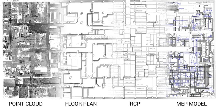
Existing Conditions 3D Laser Scanning Services for MEP/FP Documentation
As the leading provider of 3D laser scanning services, Existing Conditions delivers accurate as-built documentation of mechanical, electrical, plumbing, and fire protection (MEP/FP) systems. Laser scanning captures precise layout, dimensions, and locations of existing infrastructure, including visible structural, MEP, FP, and HVAC system elements in a point cloud. Our CAD and BIM services transforms this point cloud data into 2D as-built drawings and 3D BIM models to aid MEP/FP system engineering. This ensures that MEP systems are designed to fit precisely within the existing structure, minimizes errors and rework, and delivers superior results for our clients' projects.
MEP/FP installation involves a series of highly coordinated steps performed by our clients to integrate their systems into a building's existing structure. By working with accurate, real-time information, the project team can collaborate more effectively, share information, and coordinate their efforts with trades on-site to ensure that MEP systems seamlessly integrate with the overall building design. Accurate data ensures our clients prioritize safety, quality, and code compliance to ensure that MEP system installations are performed safely, function properly, and are reliable for the life of the building.
3D Revit Model of a Complex Mechanical Room
We use laser scanning to perform reality capture as the base for 2D CAD drawings and 3D Revit models. All elements requested that are visible and accessible at the time of the survey will be located and drawn, at a moderate level of detail, orthogonally.
What is Included in Interior MEP/FP Drawings?
Interior MEP/FP drawings often include:
- Mechanical equipment
- HVAC runs
- Piping runs
- Electrical runs
We will model elements according to their correct size and location. Often, this means modeling elements greater than 2 1/2” in diameter including any insulation. We do not typically provide details such as joints, valves, hangers or uses and functions. However, we have worked alongside many professionals that can offer these detailed services.
.png)
.png)
Existing Conditions 3D Laser Scanning Services
Over the past 27 years, we have measured, documented, and modeled over 10,000 buildings spanning over 700 million square feet across the United States, establishing ourselves as an industry leader in 3D laser scanning. Architects, builders, engineers, developers, facility managers, trust us to deliver digital representations of the as-built environment with unparalleled accuracy and efficiency. Our dedicated Project Managers provide fast and accurate 3D laser scanning services and drone imagery services, and expert CAD and BIM technicians create custom, detailed deliverables. Our greatest reward remains delivering superior-quality scan-to-BIM work and knowing we played a vital role in our clients’ unique and historic projects.
What are the Key Attributes of BIM?
Building Information Modeling, abbreviated as BIM, represents a comprehensive approach to managing building data throughout the entire life cycle of a structure. While it does encompass the creation of a 3D model, BIM extends far beyond mere visual representation. This powerful tool empowers architects, builders, engineers, developers, facility managers with the capability to effectively manage a wealth of building-related information.
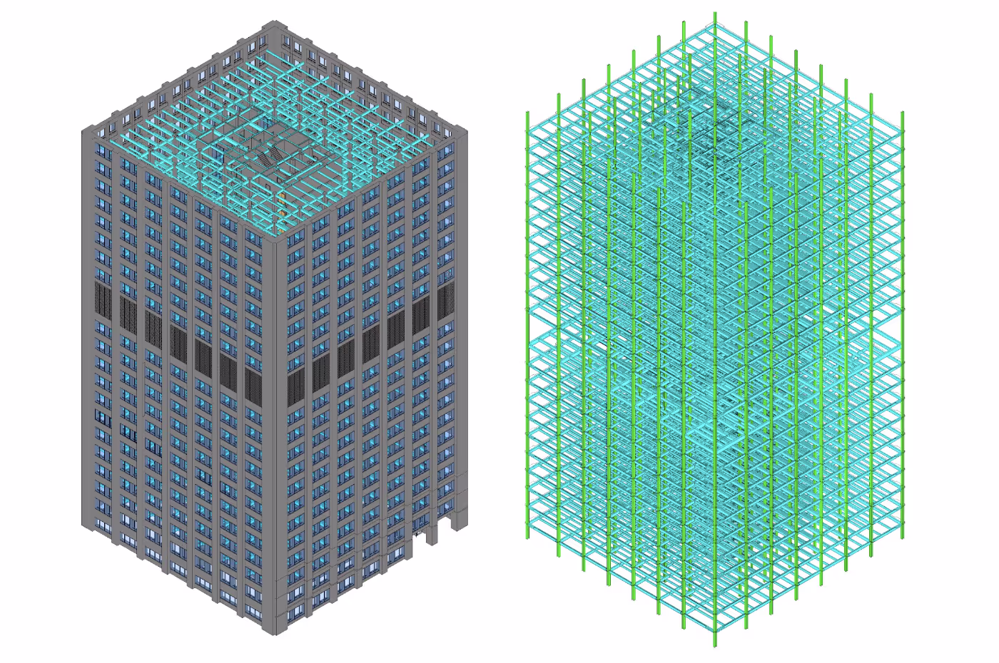
Key Attributes of BIM Include:
- Accurate Spatial Relationships: BIM models provide precise spatial relationships within a building, ensuring that elements fit together seamlessly.
- Manufacturer Details: BIM includes valuable manufacturer-specific details, allowing for informed decision-making regarding building materials and components.
- Geographic Information: BIM can incorporate geographic data, facilitating location-specific insights and considerations.
- Point Cloud Integration: One notable feature of BIM is the ability to seamlessly integrate point cloud data into the model. This integration enhances the depth and richness of information available to users.
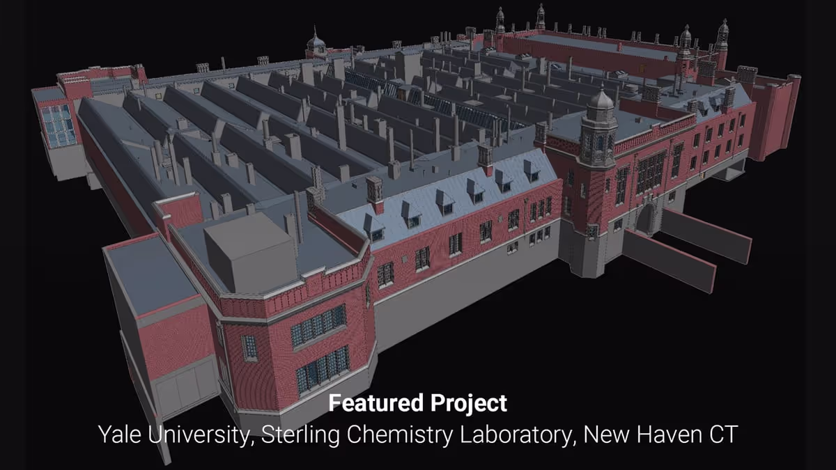
At Existing Conditions, we specialize in delivering BIM solutions tailored to your specific needs. While our primary platform for creating BIM models is Revit, we also offer flexibility by exporting to a variety of other file formats. This adaptability ensures that we can accommodate your preferred delivery method and meet your project requirements effectively.
BIM represents a holistic approach to building data management, providing stakeholders with a comprehensive toolset for informed decision-making, efficient project execution, and long-term building management. We can deliver BIM within a specific template or through your delivery method of choice. We primarily use Revit to create BIM, but we can export to many other file formats.
What is Existing Conditions Core Expertise?
At Existing Conditions, we are committed to providing architects, engineers, builders, property owners, and real estate professionals with the vital as-built building documentation they require to make informed and impactful decisions. Our approach revolves around the powerful synergy of 3D laser scanning and a transformative process known as Building Information Modeling (BIM).
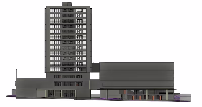
Understanding BIM
BIM stands for Building Information Modeling, a sophisticated and intelligent form of 3D modeling. This technology is the cornerstone of our efforts, offering a wealth of information that equips professionals across industries with the insights needed to enhance properties, optimize asset performance, and minimize risks.
The Power of BIM
Through BIM, architects, engineers, builders, property owners, and real estate professionals gain access to a wealth of intelligent data that elevates every phase of the building lifecycle. From initial planning and design through construction and ongoing management, BIM facilitates a safer, more efficient process that empowers decision-makers to realize their goals.
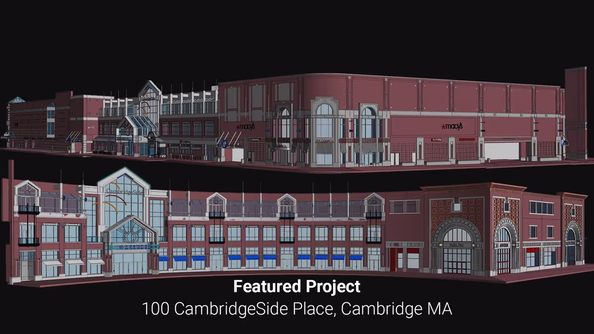
Cutting-Edge Technology for Data Capture
At Existing Conditions, we rely on the latest advancements in reality capture and 3D laser scanning technologies to swiftly and precisely deliver building information models. Our toolkit includes a comprehensive range of laser scanning equipment sourced from reputable companies like Leica and FARO. We meticulously select the scanner that best aligns with the specific requirements of each project, ensuring optimal data quality and accuracy.
Discover More About Our Technology
For a deeper dive into the technology we employ, we invite you to explore our dedicated resources. Are you interested in learning more about what building information models and precise documentation can do for you and your business?
Visit our portfolio, or contact us to connect with a member of our team.
What is Survey Control in 3D Laser Scanning?
Survey control in 3D laser scanning is the use of accurately positioned reference points, marked with reference targets, positioning targets, or scanning targets to ensure that the LiDAR scanned data aligns precisely within a spatial coordinate system. These control points are determined using traditional surveying techniques, for example GPS or total stations, and serve as fixed anchors for aligning, registering, and geo-referencing the 3D laser scans across large or complex areas. Tying the laser scan data to these known survey control points improves the accuracy and consistency of the 3D BIM models and 2D CAD drawings required for the project.
There are many different types of surveys that can be performed for real estate developments and construction projects. A survey may involve finding the existing dimensions of the building, marking underground utility locations, or locating property boundaries. Each type of survey requires a very different type of professional. If a project utilizes survey control, then all those surveys can be coordinated into a unified digital environment that references real-world locations.
Sometimes the survey control provided is localized to a specific project and other times it is tied to pre-established systems like a state planes coordinate system. Both methods involve marking various points on-site utilizing fixed elements like survey nails, cuts in masonry, checkerboard targets, etc., and then measuring the X, Y and Z values of those points. These points are called control points and are usually placed throughout the common areas of a project like up stairwells and through hallways. Usually, 3-4 control points are needed in order to properly align a project to the real-world coordinates collected on-site, however, having multiple control points located throughout a building, or at crucial measurement points, helps ensure a higher level of accuracy.
When using localized control, a special type of control point is chosen, called a basepoint, which establishes the origin of the X, Y and Z values (i.e. 0,0,0). Then all other control point locations are referenced from that basepoint.
Benchmarks are another type of control point that is utilized by land surveyors. These points are used as a single reference point from which to measure multiple other points. Projects can have more than one benchmark.
Who needs survey control?
The following lists some of the projects where survey controls may be required:
- Projects that span over large areas, or long tunnels
- Projects that involve multiple trades working together between different software
- Projects that need property line or legal boundary information
- Projects that require a high degree of vertical accuracy
Not every project needs survey control. A 3D laser scan of a building employs localized control by default and gives a spatial awareness of all visible and accessible elements of a building and surrounding property. This is all the information most projects may need for an existing conditions survey.
Who creates survey control?
Land survey professionals are required to establish a survey control for a project. This is the first stage in a project that requires survey control. Once the survey control has been set, then all other surveys can commence and tie into those pre-established control points.
On projects that don't require survey control, localized control may be utilized by our teams in order to aid in the collection of 3D laser scan data. This type of survey control typically utilizes checkerboard targets throughout the stairs and common areas of a project.
When does survey control need to be established?
Survey control needs to be established at the start of a project before any 3D laser scanning is performed by our teams. This ensures that we can tie in the data we have collected on-site to the real-world coordinates of the project.
If a project has been scanned before survey control was established, it adds a lot more complications and time. In this situation, all is not lost, there are several ways we can move forward:
- Re-scan point locations after the survey control has been performed and tie the new data into the existing set of data. This gives a higher degree of accuracy for the project but takes more time and an additional site visit.
- Utilize an existing CAD site plan to manually align and acquire coordinates for the project inside Autodesk Revit. This is a lower degree of accuracy but may provide a solution for some projects.
Not sure if you need survey control?
Reach out to our team of experts to find out if you need survey control on your project. Our trained professionals can help answer your questions and get you the information you need to make your project successful.
Existing Conditions 3D Laser Scanning Services
Over the past 27 years, we have measured, documented, and modeled over 10,000 buildings spanning over 700 million square feet across the United States, establishing ourselves as an industry leader in 3D laser scanning. Architects, builders, engineers, developers, facility managers, trust us to deliver digital representations of the as-built environment with unparalleled accuracy and efficiency. Our dedicated Project Managers provide fast and accurate 3D laser scanning services and drone imagery services, and expert CAD and BIM technicians create custom, detailed deliverables. Our greatest reward remains delivering superior-quality scan-to-BIM work and knowing we played a vital role in our clients’ unique and historic projects.
What is a 3D Point Cloud?
3D point clouds represent a critical aspect of reality capture, providing a precise and detailed snapshot of the spatial conditions of a building or space. These point clouds consist of millions of individual points, each accurately positioned in X, Y, and Z coordinates, and often accompanied by greyscale or color information. This comprehensive data capture method is particularly valuable when integrated with modeling software like Revit.
Data Generation with 3D Laser Scanners
The foundation of 3D point cloud data lies in the technology of 3D laser scanners. These devices, utilizing LiDAR technology, employ visible light to capture intricate information about a given space. The accuracy and clarity of the resulting point cloud depend heavily on the quality of the scanning equipment in use. When employing high-quality instruments, such as the ones utilized by our team, the outcome is an exceptionally precise, high-definition point cloud.
Enhancing Situational Awareness
This laser-accurate, 3D point cloud technology is instrumental in providing clients with a profound understanding of their building or site. It offers insights into various aspects, including site scape information, proximity to neighboring structures, structural concerns like sagging floors, bowing walls, deflected beams, cracked foundations, and anything within the scanner's line of sight. This wealth of data can be efficiently evaluated using Building Information Modeling (BIM) software like Revit.
Historical Record and Versatility
Many of our clients leverage 3D point cloud data as a valuable historical record of their building or site's conditions at the time of the survey. This data serves multiple purposes, including historical preservation efforts, legal documentation for property disputes or regulatory compliance, construction progress surveys to monitor changes over time, and more.
By downloading point cloud data, clients gain access to a treasure trove of information that empowers them to make informed decisions, address structural issues, and enhance project planning and management.
Existing Conditions 3D Laser Scanning Services
Over the past 27 years, we have measured, documented, and modeled over 10,000 buildings spanning over 700 million square feet across the United States, establishing ourselves as an industry leader in 3D laser scanning. Architects, builders, engineers, developers, facility managers, trust us to deliver digital representations of the as-built environment with unparalleled accuracy and efficiency. Our dedicated Project Managers provide fast and accurate 3D laser scanning services and drone imagery services, and expert CAD and BIM technicians create custom, detailed deliverables. Our greatest reward remains delivering superior-quality scan-to-BIM work and knowing we played a vital role in our clients’ unique and historic projects.
What is a Floor Plan in Construction?
A floor plan is essential in construction because it provides a detailed, scaled visual representation of a building's layout, allowing architects, engineers, builders, and developers to accurately place walls, doors, windows, and other project details, minimizing errors, ensuring efficient workflow, and facilitating accurate cost estimations throughout the project.
You need to get an accurate floor plan before you can get most other drawings because they need to tie back to the floor plan. A good as-built floor plan shows all exterior and interior walls, windows and doors, as well as other visible structural elements such as columns and stairs. Any other required details can be added as needed or shown on a separate plan.
Our 3D Revit models will contain items within Scope of Work, represented (as visible) in the corresponding view(s). For example, caps on top of columns would be considered RCP information and not included in a Floor Plan Only scope of work.
While your specific project needs may differ, typically building elements and finished spaces that are in our scope as listed below that are visible and accessible during our survey will be modeled orthogonally at a moderate level of detail:
- Floors (with elevations set in main stairwell and overall slope averaged)
- Exterior perimeter walls
- Interior partitions
- Doors
- Windows
- Stairs, elevators, ramps, and other vertical circulation
- Exposed columns (location and size only, not structural analysis)
- Vertical height information in text (bottom of deck/beam, head/sill height)
- Bathroom and kitchen cores including plumbing fixtures (not including MEP runs or appliance details)
- Square footage calculations (gross overall per floor; to exterior face of exterior walls)