

Service
Accurate Reality Capture Data to Start Accurate, and Stay Accurate™
Existing Conditions provides accurate, efficient reality capture services tailored to meet the specific needs of architects, owners, and builders. Our work empowers project teams with reliable digital documentation to reduce site visits, streamline coordination, and support informed decision-making throughout the project lifecycle.
.jpg)

What is Reality Capture?
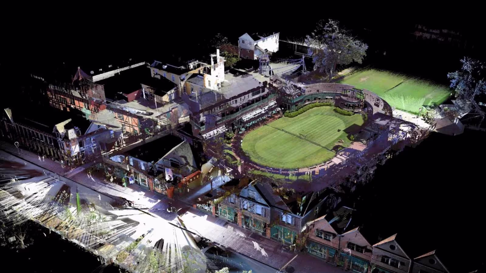
Reality capture produces a highly accurate 3D BIM model by scanning existing conditions using long-range terrestrial laser scanners. Leveraging LiDAR-based 3D laser scanning or photogrammetry, it records millions of data points to construct a high-resolution, geometrically precise digital twin. This dataset integrates with design, visualization, and analysis platforms to support informed planning, construction, and asset management.
.jpg)
-2.jpg)
.jpg)
No items found.

How Reality Capture Technology Helps You Plan, Build, and Manage Better
Existing Conditions’ reality capture services provide precise as-built documentation that enhances your project efficiency, minimizes costly rework, and supports informed decision-making throughout the building lifecycle.
Streamlined collaboration across teams
.svg)
Enable seamless collaboration with contractors and engineers using consistent, reliable scan to BIM survey data.
Enhanced site safety through remote access
Data-driven planning and execution
High-accuracy digital records
Elimination of assumptions in design and construction
Reduced timelines and overall project costs
How Reality Capture Technology Helps You Plan, Build, and Manage Better
Existing Conditions’ reality capture services provide precise as-built documentation that enhances your project efficiency, minimizes costly rework, and supports informed decision-making throughout the building lifecycle.
Streamlined collaboration across teams
Enhanced site safety through remote access
Data-driven planning and execution
High-accuracy digital records
Elimination of assumptions in design and construction
Start Accurate. Stay Accurate.

Trusted Partner
We see our work as a partnership, aiming for long-term relationships where your success drives ours.
Expert Team
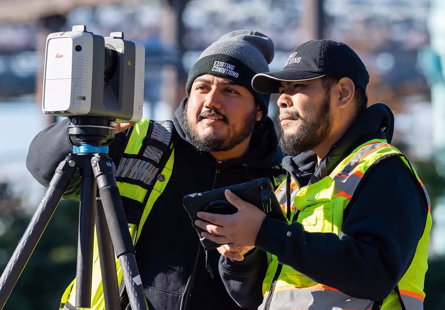
Our skilled Project Managers use LiDAR laser scanners to capture precise layouts, dimensions, and details of all building features.

Comprehensive Data Capture
Laser scanners gather millions of data points, creating a point cloud that captures every detail, even in hard-to-reach areas.

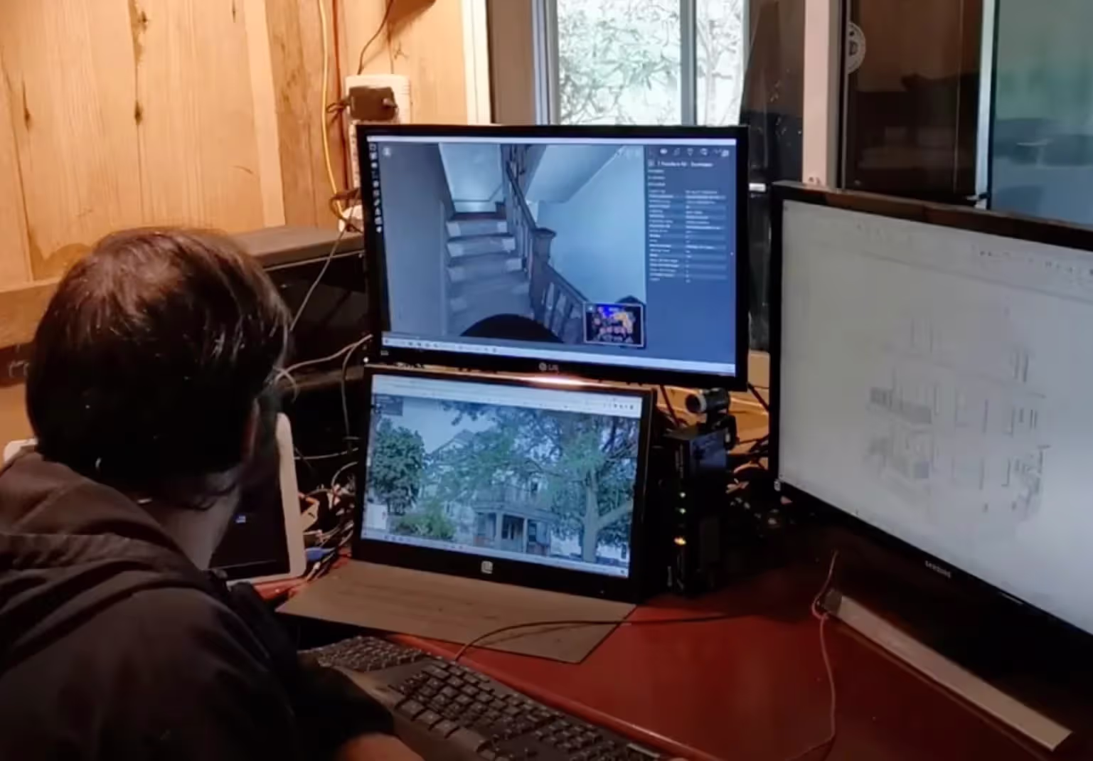
As-Built Drawings & 3D BIM Models
We convert point clouds into 2D CAD drawings, 3D BIM models, TruViews, virtual tours, and more—perfectly tailored to your project.

Trusted Partner
We see our work as a partnership, aiming for long-term relationships where your success drives ours.

Expert Team
Our skilled Project Managers use LiDAR laser scanners to capture precise layouts, dimensions, and details of all building features.

Comprehensive Data Capture
Laser scanners gather millions of data points, creating a point cloud that captures every detail, even in hard-to-reach areas.

As-Built Drawings & 3D BIM Models
We convert point cloud data into custom 2D CAD drawings, 3D BIM models, TruViews, virtual tours, and more—perfectly tailored to your project.
Industries We Serve
3D laser scanning and drone surveys support many industries with precise as-built documentation to optimize planning and mitigate costly errors.
Architecture

Construction

Facilities Management

Engineering

Commercial Real Estate

Entertainment


What to Expect
Our 3D Laser Scanning Process
.jpg)
Frequently Asked Questions
No items found.
Articles
.avif)
What is LiDAR?
LiDAR, or Light Detection and Ranging, is a remote sensing technology that uses a pulsed laser to measure distances to a target. 3D laser scanners contain a LiDAR sensor that sends out beams of laser light in all directions and records how long it takes for them to return to the sensor.
Read More

What Is 3D Laser Scanning?
3D laser scanning is a way of capturing and creating a digital footprint of a physical structure. In less than two minutes, our small and lightweight laser scanning equipment collects up to 2 million points per second, gathering real-time measurements and information from a site.
Read More
Case Studies

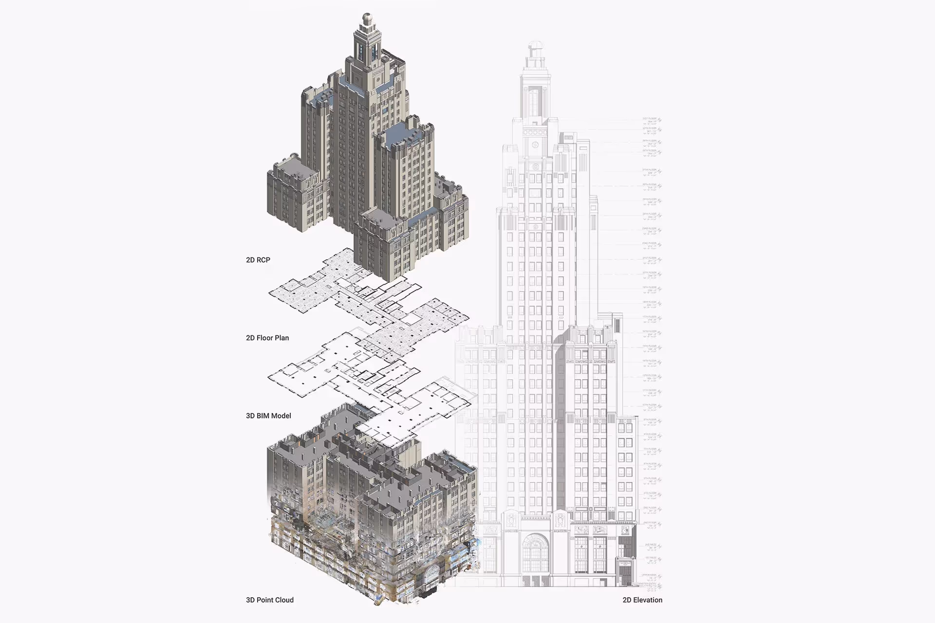
Woolworth Building Pinnacle Penthouse
Existing Conditions was selected to provide 3D laser scanning and construction drone services for the iconic Pinnacle Penthouse at the Woolworth Building, as the purchaser intends to restore portions of the exterior to more closely reflect the original 1913 Cas Gilbert design and finish the interior living space. With the help of Existing Conditions, this blank canvas of architectural history will be transformed into a masterpiece.
Read More

Williams College
Our work with Williams College is one of Existing Conditions' largest projects to date. This collaboration with one of the most prestigious institutions in the United States began in 2015. After seeing the power of what Existing Conditions could provide for them for a single building, Williams College selected our team to 3D laser scan the entire campus of over 4 million square feet using the latest LiDAR technology and provide them with accurate 2D drawings of all their spaces.
Read More
-1%20(1).webp)
Riverside Labs Life Sciences Campus
The Riverside Labs project highlights the collaboration between Existing Conditions, Shawmut Design and Construction & Gensler. By providing comprehensive as-built documentation services both pre and post-demolition, Existing Conditions demonstrated our 3D laser scanning expertise, crucial for the success of this endeavor. A significant challenge for Gensler at Riverside Labs was the availability of accurate and comprehensive digital as-built documentation. Initially equipped with only a basic set of 2D CAD drawings, the project lacked a detailed 3D Revit model, particularly for core and shell components. Our task was to create accurate, as-built drawings and a 3D BIM model by 3D laser scanning the site to prevent future hiccups, especially concerning MEP (mechanical, electrical, and plumbing) systems and structural placements.
Read More


